
Catalão
| Catalão | ||||
|---|---|---|---|---|

|
||||
| coat of arms | flag | |||
 |
 |
|||
| cards | ||||
|
||||
| Basic data | ||||
| State : |
|
|||
| Administrative structure : | Midwest | |||
| State : |
|
|||
| Mesoregion : | South Goiás | |||
| Microregion : | Catalão | |||
| Neighboring municipalities: | Campo Alegre de Goiás , Paracatu ( MG ), Guarda-Mor (MG), Coromandel , Davinópolis , Ouvidor , Três Ranchos , Cascalho Rico (MG), Araguari (MG), Cumari , Goiandira , Ipameri | |||
| Distance to Goiânia : | 253 km | |||
| Geographic location : | 18 ° 10 ′ S , 47 ° 57 ′ W | |||
| Time zone : |
UTC -3 summer : UTC-2 |
|||
| Area : | 3,777.652 km² | |||
| Residents : | 86,597 | |||
| Population density : | 22.9 inhabitants / km² | |||
| Height : | 835 m | |||
| Post code (CEP): | 75700-000 | |||
| Telephone code : | +55 64 | |||
| City administration address: | Prefeitura Municipal de Catalão Rua Nassim Agel, 505 - Centro Catalão - Goiás CEP: 75701-050 |
|||
| Official website: | catalao.go.gov.br | |||
| Anniversary: | 20th of August | |||
| Founding year: | 1833 | |||


Catalão is a municipality ( município ) in the central state of Goiás in Brazil . Catalão is located in the South Goiás mesoregion and the Catalão microregion .
Catalão is near the Emborcação reservoir . There is an assembly plant for Mitsubishi Motors vehicles and a John Deere factory .

Cornélio Ramos Museum

Parking lot at the local Mitsubishi assembly plant

Panoramic view of the place
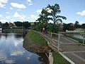
Represa do Monsenhor Souza
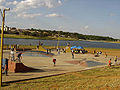
Playground and sports field by an artificial lake

Dom Bosco Church (20th century)

Evening view over the lake to the town, with a blossom in the foreground


Web links
Individual evidence
- ↑ SEPLAN: Road kilometers to Goiânia ( Memento of the original from March 3, 2016 in the Internet Archive ) Info: The archive link was inserted automatically and has not yet been checked. Please check the original and archive link according to the instructions and then remove this notice.
- ↑ First results of the 2010 census in Goiás (PDF; 30 kB), carried out by IBGE .
Abadia de Goiás | Abadiânia | Acreúna | Adelândia | Água Fria de Goiás | Água Limpa | Águas Lindas de Goiás | Alexânia | Aloândia | Alto Horizonte | Alto Paraíso de Goiás | Alvorada do Norte | Amaralina | Americano do Brasil | Amorinópolis | Anápolis | Annexuera | Anicuns | Aparecida de Goiânia | Aparecida do Rio Doce | Aporé | Araçu | Aragarças | Aragoiânia | Araguapaz | Arenópolis | Aruanã | Aurilândia | Avelinópolis | Baliza | Barro Alto | Bela Vista de Goiás | Bom Jardim de Goiás | Bom Jesus de Goiás | Bonfinópolis | Bonópolis | Brazabrantes | Britânia | Buriti Alegre | Buriti de Goiás | Buritinópolis | Cabeceiras | Cachoeira Alta | Cachoeira de Goiás | Cachoeira Dourada | Caçu | Caiapônia | Caldas Novas | Caldazinha | Campestre de Goiás | Campinaçu | Campinorts | Campo Alegre de Goiás | Campo Limpo de Goiás | Campos Belos | Campos Verdes | Carmo do Rio Verde | Castelândia | Catalão | Caturaí | Cavalcante | Ceres | Cezarina | Chapadão do Céu | Cidade Ocidental | Cocalzinho de Goiás | Colinas do Sul | Córrego do Ouro | Corumbá de Goiás | Corumbaíba | Cristalina | Cristianópolis | Crixás | Cromínia | Cumari | Damianópolis | Damolândia | Davinópolis | Diorama | Divinópolis de Goiás | Doverlândia | Edealina | Edéia | Estrela do Norte | Faina | Fazenda Nova | Firminópolis | Flores de Goiás | Formosa | Gameleira de Goiás | Goianápolis | Goiandira | Goianésia | Goiânia | Goianira | Goiás Velho | Goiatuba | Gouvelândia | Guapó | Guaraíta | Guarani de Goiás | Guarinos | Heitoraí | Hidrolândia | Hidrolina | Iaciara | Inaciolândia | Indiara | Inhumas | Ipameri | Ipiranga de Goiás | Iporá | Israelândia | Itaberaí | Itaguari | Itaguaru | Itajá | Itapaci | Itapirapuã | Itapuranga | Itarumã | Itauçu | Itumbiara | Ivolândia | Jandaia | Jaraguá | Jataí | Jaupaci | Jesúpolis | Joviânia | Jussara | Lagoa Santa | Leopoldo de Bulhões | Luziânia | Mairipotaba | Mambaí | Mara Rosa | Marzagão | Matrinchã | Maurilândia | Mimoso de Goiás | Minaçu | Mineiros | Moiporá | Monte Alegre de Goiás | Montes Claros de Goiás | Montividiu | Montividiu do Norte | Morrinhos | Morro Agudo de Goiás | Mossâmedes | Mozarlândia | Mundo Novo | Mutunópolis | Nazario | Nerópolis | Niquelândia | Nova America | Nova Aurora | Nova Crixás | Nova Glória | Nova Iguaçu de Goiás | Nova Roma | Nova Veneza | Novo Brasil | Novo Gama | Novo Planalto | Orizona | Ouro Verde de Goiás | Ouvidor | Padre Bernardo | Palestina de Goiás | Palmeiras de Goiás | Palmelo | Palminópolis | Panamá | Paranaiguara | Paraúna | Perolândia | Petrolina de Goiás | Pilar de Goiás | Piracanjuba | Piranhas | Pirenópolis | Pires do Rio | Planaltina | Pontalina | Porangatu | Porteirão | Portelândia | Posse | Professor Jamil | Quirinópolis | Rialma | Rianápolis | Rio Quente | Rio Verde | Rubiataba | Sanclerlândia | Santa Bárbara de Goiás | Santa Cruz de Goiás | Santa Fe de Goiás | Santa Helena de Goiás | Santa Isabel | Santa Rita do Araguaia | Santa Rita do Novo Destino | Santa Rosa de Goiás | Santa Tereza de Goiás | Santa Terezinha de Goiás | Santo Antônio da Barra | Santo Antônio de Goiás | Santo Antônio do Descoberto | São Domingos | São Francisco de Goiás | São João d'Aliança | São João da Paraúna | São Luís de Montes Belos | São Luiz do Norte | São Miguel do Araguaia | São Miguel do Passa Quatro | São Patrício | São Simão | Senador Canedo | Serranópolis | Silvânia | Simolândia | Sítio d'Abadia | Taquaral de Goiás | Teresina de Goiás | Terezópolis de Goiás | Três Ranchos | Trindade | Trombas | Turvânia | Turvelândia | Uirapuru | Uruaçu | Uruana | Urutaí | Valparaíso de Goiás | Varjão | Vianópolis | Vicentinópolis | Vila Boa | Vila Propício