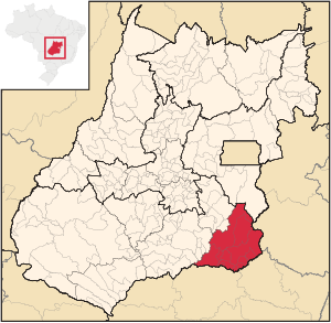
Catalão microregion
| Catalão microregion | |
|---|---|
| map | |
| Basic data | |
| State : |
|
| Administrative structure : | Midwest |
| State : |
|
| Mesoregion : | South Goiás |
| Time zone : |
UTC -3 summer : UTC-2 |
| Area : | 15,238.60 km² |
| Residents : | 147.191 IBGE : 2010 |
| Population density : | 9.7 inhabitants / km² |
| Number of municipalities: | 11 |
The Catalão microregion is a statistical region of the IBGE (Instituto Brasileiro de Geografia e Estatística) in the southeast of the Brazilian state of Goiás . It belongs to the South Goiás mesoregion .
Municipalities in the Catalão microregion
A region with a hilly and flat landscape with extensive cattle breeding, soy plantations and a regional center in Catalão , which is growing very quickly.
| local community |
Area (km²) |
Population (2010) |
GDP 2006 ( R $ 1,000.00) |
GDP per capita 2006 |
|---|---|---|---|---|
| Annexuera | 57 | 1,017 | 5,950 | 6,510 |
| Campo Alegre de Goiás | 2,463 | 6,057 | 110,567 | 24,451 |
| Catalão | 3,778 | 86,597 | 2,488,759 | 34,720 |
| Corumbaíba | 1,482 | 8,164 | 177.466 | 23,703 |
| Cumari | 580 | 2,961 | 21,982 | 6,724 |
| Davinópolis | 520 | 2,050 | 14,912 | 7,349 |
| Goiandira | 561 | 5,268 | 32,081 | 6,868 |
| Ipameri | 4,369 | 24,745 | 257,489 | 10,736 |
| Nova Aurora | 303 | 2,069 | 12,891 | 6,485 |
| Ouvidor | 414 | 5,446 | 145.382 | 30,992 |
| Três Ranchos | 282 | 2,817 | 17,840 | 5,484 |
| Total: | 15,239 | 147.191 | 3,285,319 | 22,320 |
See also
Individual evidence
- ↑ First results of the 2010 census in Goiás (PDF; 30 kB), (Portuguese); Retrieved October 20, 2011
- ↑ a b IBGE : Produto Interno Bruto a preços correntes e Produto Interno Bruto per capita , segundo as Grandes Regiões, Unidades da Federação e Municípios - 2003-2006 ( Memento of the original from March 6, 2009 in the Internet Archive ) Info: The archive link was inserted automatically and not yet tested. Please check the original and archive link according to the instructions and then remove this notice. , ( port .), PDF file; Retrieved October 20, 2011
