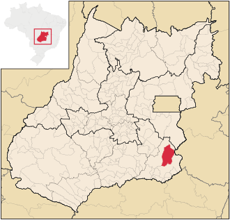
Campo Alegre de Goiás
| Campo Alegre de Goiás | |||
|---|---|---|---|
| coat of arms | flag | ||
| cards | |||
|
|||
| Basic data | |||
| State : |
|
||
| Administrative structure : | Midwest | ||
| State : |
|
||
| Mesoregion : | South Goiás | ||
| Microregion : | Catalão | ||
| Surrounding communities: | Catalão , Cristalina , Ipameri , Paracatu ( Minas Gerais ) | ||
| Distance to Goiânia : | 326 km | ||
| Geographic location : | 17 ° 38 ′ S , 47 ° 47 ′ W | ||
| Time zone : |
UTC -3 summer : UTC-2 |
||
| Height : | 877 m | ||
| Area : | 2,463.014 km² | ||
| Residents : | 6,057 | ||
| Population density : | 2.5 inhabitants / km² | ||
| Telephone code : | +5564 | ||
| Post code (CEP): | 75795-000 | ||
| City administration address: | Prefeitura Municipal de Campo Alegre Praça Manoel Pio Pereira nº 01 - Centro |
||
| Official Website: | campoalegre.go.gov.br | ||
| Anniversary: | November 12th | ||
| Church planting: | 1953 | ||
| politics | |||
| Mayoress : | Maria Aparecida Fleuri Siqueira ( PP ) (2009–2012) | ||
Campo Alegre de Goiás (German: Fröhliches Feld von Goiás ) is a municipality ( Portuguese : município) in the central state of Goiás in Brazil , which was founded on November 12, 1953.
Campo Alegre is located in the South Goiás mesoregion and the Catalão microregion . In 2010 the population was 6,057. With an extension of the municipality of 2,463.014 km², the population density is 2.5 inhabitants / km². Campo Alegre is shaped by agriculture and livestock .
Individual evidence
- ↑ SEPLAN: Road kilometers to Goiânia ( Memento of the original from March 3, 2016 in the Internet Archive ) Info: The archive link was inserted automatically and has not yet been checked. Please check the original and archive link according to the instructions and then remove this notice.
- ↑ First results of the 2010 census in Goiás (PDF; 29 kB), carried out by IBGE .


