Leopoldo de Bulhoes
| Município de Leopoldo de Bulhões Leopoldo de Bulhões |
|||
|---|---|---|---|
|
Church of Nossa Senhora Auxiliardo de Bulhões
|
|||
|
|
|||
| Coordinates | 16 ° 37 ′ S , 48 ° 45 ′ W | ||
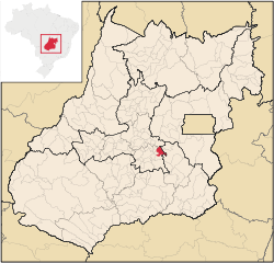
 Location of the municipality in the state of Goiás Location of the municipality in the state of Goiás
|
|||
| Symbols | |||
|
|||
| founding | 2nd September 1948 (age 71) | ||
| Basic data | |||
| Country | Brazil | ||
| State | Goiás | ||
| ISO 3166-2 | BR-GO | ||
| height | 1030 m | ||
| climate | tropical mountain climate, Aw | ||
| surface | 472.7 km² | ||
| Residents | 7882 (2010) | ||
| density | 16.7 Ew. / km² | ||
| estimate | 7647 (July 1, 2019) | ||
| Parish code | IBGE : 5212303 | ||
| Post Code | 75190-000 | ||
| Telephone code | (+55) 62 | ||
| Time zone | UTC −3 | ||
| Website | leopoldodebulhoes.go (Brazilian Portuguese) | ||
| politics | |||
| City Prefect | João Alecio Mendes (2017-2020) | ||
| Political party | PR | ||
| economy | |||
| GDP | 205,519 thousand. R $ 26,440 R $ per capita (2017) |
||
| HDI | 0.659 (medium) (2010) | ||
Leopoldo de Bulhões , officially Portuguese Município de Leopoldo de Bulhões , is a Brazilian municipality in the state of Goiás . It is located southwest of the Brazilian capital Brasília and 56 km east of the capital Goiânia and borders in the west on the metropolitan region Goiânia . As of July 1, 2019, the population was estimated at 7647 inhabitants, who are called Leopoldenses ( leopoldenses ) and live on a community area of around 472.7 km².
history
The place arose from a settlement called Pindaibinha on the left side of the Pindaíba stream. In 1928 it was connected to the Estrada de Ferro Goiás railway line . Until it became independent on January 1, 1949 based on State Law No. 127 of September 21, 1948, it belonged to the city of Silvânia . The place and district were named in 1931 after the politician José Leopoldo de Bulhões Jardim .
Geographical location
Leopoldo de Bulhões borders the municipalities
- to the north at Anápolis and Gameleira de Goiás
- from east to south on Silvânia
- in the southwest of Caldazinha
- in the west Bonfinópolis
- in the northwest at Goianápolis
The biome is the Brazilian cerrado . The altitudes of the municipal area are between 1000 and 1060 meters above sea level. The city has a small lake called Lago de Leopoldo de Bulhões on the western edge .
traffic
The place is on the federal highway BR-457 and the state road GO-010 .
Web links
Individual evidence
- ↑ Leopoldo de Bulhões climate: average temperature, weather by month, Leopoldo de Bulhões average temperature. In: de.climate-data.org. Retrieved July 15, 2020 .
- ↑ a b c Leopoldo de Bulhões - Panorama. IBGE , accessed July 15, 2020 (Brazilian Portuguese).
- ↑ Alecio Mendes 22 (Prefeito). In: todapolitica.com. Eleições 2016, accessed July 15, 2020 (Brazilian Portuguese).
- ↑ SEPLAN: Road kilometers to Goiânia ( Memento from February 5, 2009 in the Internet Archive )
- ↑ Leopoldo de Bulhões - História. IBGE , accessed July 15, 2020 (Brazilian Portuguese).


