Rio Meia Ponte
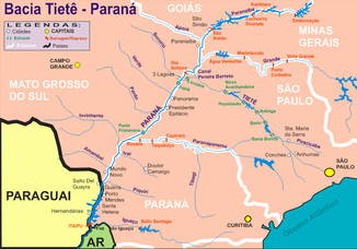
The Rio Meia Ponte is a right tributary of the Rio Paranaíba in Brazil in the state of Goiás and belongs to the Paraná river system . West of the dam of the Cachoeira Dourada reservoir , it flows into the Rio Paranaíba as a right tributary coming from the north (see map; the Meia Ponte is not shown there).
River course
The headwaters are located northeast of the town of Itauçu in the municipality of Taquaral de Goiás, west of the Serra dos Brandões mountains and about 60 km north-northwest of Goiânia. From Itauçu, the state road GO-070 follows the course of the river on the west side to Goiânia. The Rio Meia Ponte flows through the capital in the northeast quadrant and changes its direction towards the city to the south. From the width of Bela Vista de Goiás , the river changes its general direction of flow to south-southwest, which it maintains until its confluence with the Rio Paranaíba on the border with Minas Gerais . The estuary is about 15 km west of the city of Cachoeira Dourada .
In the village of Vale do Paraíso in the municipality of Piracanjuba , the Rio Meia Ponte is dammed in the small reservoir Represa do Rochedo (German: Felsdamm, Felsklippe ).
The Rio Meia Ponte and its 30 tributaries together drain 38 municipalities.
Water pollution
For the metropolitan region of Goiânia with around two million and for the almost three million inhabitants in its catchment area, the Rio Meio Ponte is very important for the water supply. But the river receives large amounts of garbage, industrial waste and untreated sewage , which severely affects the quality of its water. The city of Goiânia, for example, discharges over 90% of its wastewater untreated into the river. A sewage treatment plant is currently under construction in Goiânia.
A measurement of the water quality downstream from Goiânia showed that the river contains a low level of dissolved oxygen over a stretch of 60 kilometers below Goiânia and thus only allows the survival of aquatic organisms to a very limited extent . The latter are a very important requirement not only for agricultural activities.
In addition, the dry summers last up to six months, meaning that the Meia Ponte does not carry enough water to meet all the water needs in the metropolitan area of Goiânia. Rationing of water is therefore common in summer. A project was recently initiated to rehabilitate this important river.
Web links
- Map: Hydrographic basins, rivers and lakes in Goiás , (Portuguese and English)
- Terrain map of Goiás
- Meia Ponte: Education about pollution and protection , (port.)
Individual evidence
- ↑ a b Encontradas novas nascentes do Rio Meia Ponte, em Goiás , (port.) (German: New sources of the Rio Meia Ponte discovered )
- ↑ FIALHO, Afonso P .; OLIVEIRA, Leandro G .; TEJERINA-GARRO, Francisco L. and GOMES, Luiz C .: Fish assemblage structure in tributaries of the Meia Ponte River, Goiás, Brazil. Neotrope. ichthyol .. 2007, vol.5, n.1, pp. 53-60 doi : 10.1590 / S1679-62252007000100007 , ( Portuguese and English)

