Pilar (Capiz)
| Municipality of Pilar | ||
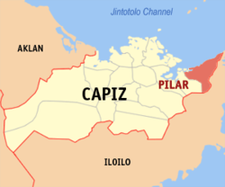
| Location of Pilar in the province of Capiz | ||
|---|---|---|

|
||
| Basic data | ||
| Region : | Western Visayas | |
| Province : | Capiz | |
| Barangays : | 24 | |
| District: | 1. District of Capiz | |
| PSGC : | 061911000 | |
| Income class : | 3rd income bracket | |
| Households : |
May 1, 2000 census
|
|
| Population : | 45.287 August 1, 2015 census
|
|
| Population density : | 580.7 inhabitants per km² | |
| Area : | 77.99 km² | |
| Coordinates : | 11 ° 29 ′ N , 123 ° 0 ′ E | |
| Postal code : | 5804 | |
| Geographical location in the Philippines | ||
|
|
||
Pilar is the easternmost Greater Municipality in the province of Capiz on the island of Panay in the Philippines . It has 45,287 inhabitants (August 1, 2015 census) who live in 24 barangays . It belongs to the third income bracket of the communities in the Philippines and is described as partially urban .
geography
Pilar is located on the north coast of Panay Island on Pilar Bay , where the four-hectare Tukad Reef is about 10 km off the coast of the municipality. The provincial capital, Roxas City , is about 46 km west of the municipality and can be reached from there via the coastal road. The neighboring communities are President Roxas in the west, Carles and Balasan in the east. Iloilo City International Airport is 146 km away.
Attractions
The highest statue of the Virgin Mary on the Asian continent is in the community. It is 26 meters high and is located in the Agtaline Shrine . The Lola Ibe is also laid out in the church. Born as Maria de Juan Basañes, she was exhumed 10 years after her death and no significant decomposition process was found. Her body was mummified in a natural process, which is considered a miracle in the Philippines.
The two caves Balisong and Puting Bato, as well as the three waterfalls Hinulugan, in Brgy are located in the area of the municipality . Tabunacan, Lalawgon, in the Brgy. Yating, and Kawawa, at Brgy. San Silvestre.
Barangays
|
|
