
Piz Varuna
| Piz Varuna | ||
|---|---|---|
 View of the Piz Varuna from the south, Alp Somdoss |
||
| height | 3453 m above sea level M. | |
| location | Graubünden , Switzerland | |
| Mountains | Bernina Group , Eastern Alps | |
| Dominance | 2.6 km → Sasso Rosso | |
| Notch height | 222 m ↓ Passo di Gembré | |
| Coordinates , ( CH ) | 46 ° 21 '8 " N , 9 ° 59' 35" O ( 796 591 / 136 627 ) | |
|
||

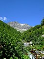
The Piz Varuna (formerly also Italian Pizzo Verona or Pizzo di Verona ) is a mountain in the Eastern Alps and belongs to the Bernina group . He forms with 3453 m above sea level. M. the highest elevation in a smaller massif with the Piz Canton ( 3110 m above sea level ) and the Cima Val Fontanà ( 3070 m above sea level ) and the Sasso Rosso ( 3416 m above sea level ). The mountain lies between the Swiss Poschiavo and the Italian Valmalenco .
The ice masses of Piz Varuna flow north over the Vadret da Varuna into the Palü Glacier and east over the Vadret da Canton into Val Varuna in the Poschiavo. The south-facing Vedretta di Varuna has only flowed off via the Valmalenco for about ten years . There used to be a glacier break and a glacier tongue over the Val Tempesta into the Val d'Ursé in Valposchiavo.
Until shortly after the Second World War , the border between Italy and Switzerland ran over the Piz Varuna along the watershed on the Vedretta di Varuna to the Cima Val Fontanà . Since the glacier melted , the border has been moved back to the detriment of Switzerland.

The Piz Varuna on the Siegfried map from 1877, labeled as "Pizzo di Verona"

View of the Piz Varuna with the Curnasel and the Piz Canton from the east (Alp Grüm)
View of the Piz Varuna from the Val Varuna

Seen from Poschiavo


