Pyassina
|
Pyasina River Пясина |
||
|
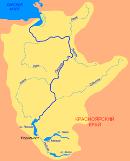
Catchment area of the Pyassina |
||
| Data | ||
| Water code | RU : 17020000112116100117923 | |
| location | Krasnoyarsk Region (Russia) | |
| River system | Pyassina | |
| origin |
Lake Pjassino 70 ° 3 ′ 37 ″ N , 88 ° 4 ′ 4 ″ E |
|
| Source height | 28 m | |
| muzzle | in the Pyassinabus ( Kara Sea ) coordinates: 73 ° 53 ′ 12 " N , 87 ° 4 ′ 21" E 73 ° 53 ′ 12 " N , 87 ° 4 ′ 21" E |
|
| Mouth height | 0 m | |
| Height difference | 28 m | |
| Bottom slope | 0.03 ‰ | |
| length | 818 km | |
| Catchment area | 182,000 km² | |
| Outflow at the level at the mouth |
MQ |
2600 m³ / s |
| Left tributaries | Pura , Mokoritto , Agapa | |
| Right tributaries | Dudypta , Jangoda , Tareja , Binyuda , Negro | |
The Pjassina ( Russian Пясина , also Pjasina ) is a 818 km long river in northern Siberia ( Russia , Asia ) that flows into the Arctic Kara Sea .
course
The Pjassina flows from the Pjassinosee northwest of the Putorana Mountains at 28 m in a north-easterly direction and crosses for the first 150 km to the confluence of the Dudypta (Дудыпта) moraine deposits in a narrow valley. Below, in the area of the North Siberian Lowlands , the valley widens; here the river is already over a kilometer wide in places, mends itself and forms a multitude of arms, for example in the area of the confluences of Jangoda (Янгода) and Mokoritto (Мокоритто).
At the mouth of the Tareja (Тарея), the Pyassina turns north of the 73rd parallel and south of the Byrranga Mountains to the west. Below the mouth of the Pura (Пура), the Pyassina breaks through the south-westerly foothills of the Byrranga Mountains, which are only up to 200 m high, in a northerly direction, and finally flows into the Pyassina Bay of the Kara Sea .
East of the estuary-like, 3 km wide and 10 km deep main arm near the mouth , the Pyassina forms a delta . When the tide is low, the tides can be felt up to the mouth of the Tareja (about 300 km above the mouth of the Pyassina).
Catchment area and water supply
The catchment area of the Pjassina covers 182,000 km², 10,450 km² are covered by over 60,000 lakes. Below Lake Pjassinose the mean water flow is 560 m³ / s, at the mouth 2,600 m³ / s.
Climate, fauna and navigability
The Pyassina freezes between late September / early October and June. In the ice-free time, it is navigable along its entire length. The river and its tributaries are very rich in fish.
