Lake Pyassino
| Lake Pyassino (Озеро Пясино) | ||
|---|---|---|

|
||
| Satellite image of Lake Pyasino | ||
| Geographical location | Krasnoyarsk Region ( Russia ) | |
| Tributaries | Norilka , Dschangy , Ambarnaya | |
| Drain | Pyassina | |
| Location close to the shore | Norilsk | |
| Data | ||
| Coordinates | 69 ° 52 ' N , 87 ° 33' E | |
|
|
||
| Altitude above sea level | 28 m | |
| surface | 735 km² | |
| length | 70 km | |
| width | 15 km | |
| Maximum depth | 10 m | |
| Catchment area | 24,000 km² | |
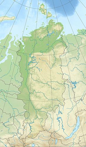
Lake Pyassino ( Russian Озеро Пясино , also Lake Pyasino ) is a lake in the former Taimyr Autonomous Okrug in the north of the Russian Krasnoyarsk region in Siberia .
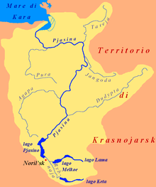
It is 735 km² and only a maximum of 10 meters deep. Lake Pjassino is located in the lowlands northwest of the Putorana Mountains south of the Taimyr Peninsula at a height of 28 m . It extends for about 70 kilometers in a north-south direction with a width of up to 15 kilometers.
The most important tributary of the lake is the Norilka (also Norilskaja ) coming from the southeast . A large number of smaller rivers, such as the Dschangy and Ambarnaya, also flow into it . In the northeast, the Pyassina leaves the lake.
Lake Pjassino freezes from October to June.
The town of Norilsk with its districts Talnach and Kajerkan is 15 to 25 kilometers south or south-east of the lake , whereas the immediate vicinity of the lake is uninhabited.
pollution
There are hardly any fish in the lake because of the discharge of sewage from the metallurgical plants of Norilsk Nickel . Measurements showed high heavy metal concentrations.
Web links
Individual evidence
- ↑ a b Lake Pyasino in the State Water Register of the Russian Federation (Russian)
- ↑ a b c d e Article Lake Pyassino in the Great Soviet Encyclopedia (BSE) , 3rd edition 1969–1978 (Russian)
- ↑ Topographic map (1: 200.000, p. R-45-21,22, edition 1971), large part of Lake Pjassino (far right), u. a. with the Yenisei near Dudinka , on mapr45.narod.ru (with heights above sea level)
- ^ Environmental Challenges in the Arctic Norilsk Nickel: The Soviet Legacy of Industrial Pollution. Bellona foundation, 2010, archived from the original on February 3, 2015 ; accessed on July 14, 2020 (English).
- ↑ Alexander V. Zhulidov, Richard D. Robarts, Dmitry F. Pavlov, J. Kämäri, Tatiana Yu. Gurtovaya, JJ Meriläinen, Igor N. Pospelov: Long-term changes of heavy metal and sulfur concentrations in ecosystems of the Taymyr Peninsula (Russian Federation) North of the Norilsk Industrial Complex . In: Environmental Monitoring and Assessment . tape 181 , 2011, p. 539–553 , doi : 10.1007 / s10661-010-1848-y (English).

