
Podel movement
|
Podel movement
City of Stadtroda
Coordinates: 50 ° 52 ′ 37 " N , 11 ° 42 ′ 11" E
|
||
|---|---|---|
| Height : | 215 m above sea level NN | |
| Area : | 1.03 km² | |
| Residents : | 21st | |
| Population density : | 20 inhabitants / km² | |
| Incorporation : | July 1, 1950 | |
| Incorporated into: | Gernewitz | |
| Postal code : | 07646 | |
| Area code : | 036428 | |
Location of Podelsatz in Thuringia |
||
 View of the village from Podelsatz
|
||

Podelsatz is a hamlet belonging to Stadtroda in the Saale-Holzland district in Thuringia .
geography
The hamlet is located a little north of the federal motorway 4 and the Weimar – Gera railway line and northwest of Stadtroda above the broad, densely wooded erosion valley of the Grünzigbach. The 102.8 ha area is heavily docked .
history
Podelsatz was first mentioned on December 1, 1433. The first proven owners of the once Slavic village were the Puster von Drackendorf family . The Brünau and Münsch families were later successors. From 1935 to 1937, the first motorway bridge of today's federal motorway 4 was built at the entrance to the village over the 200 m wide valley. On July 1, 1950, Podelsatz was incorporated into Gernewitz.
Since 1990 there has been a riding stables in the hamlet with a park stable for foreign horses.

Town center
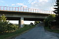
Motorway bridge in front of the site

fire Department

View of the village from Podelsatz


Web links
Individual evidence
- ^ Wolfgang Kahl : First mention of Thuringian towns and villages. A manual. 5th, improved and considerably enlarged edition. Rockstuhl, Bad Langensalza 2010, ISBN 978-3-86777-202-0 , p. 220.
- ↑ Website of the riding school. Accessed on January 1, 2019
- ^ Podelsatz on the Stadtroda website.Retrieved on November 20, 2011