Point Fortin
| Borough of Point Fortin Point Fortin |
||
|---|---|---|
|
|
||
| Coordinates | 10 ° 10 '32 " N , 61 ° 41' 3" W | |
| Basic data | ||
| Country | Trinidad and Tobago | |
| Point Fortin | ||
| ISO 3166-2 | TT-PTF | |
| surface | 24 km² | |
| Residents | 20,235 (2011) | |
| density | 843.1 Ew. / km² | |
| Website | pointfortinborough.com (en) | |
| politics | ||
| mayor | Abdon Mason | |
| Political party | PNM | |
|
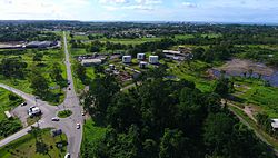
Point Fortin (in the background)
|
||
Point Fortin is a city in Trinidad and Tobago . It has the status of a borough , comparable to a German independent city , and is therefore one of five Trinidadian cities not assigned to any region.
location
Point Fortin is located in the southwestern part of Trinidad, about 30 km west of San Fernando . The city lies on the Gulf of Paria and is surrounded by the Siparia region on the land side .
history
In 1906 the city grew with the help of oil production, which is particularly high in this region. Between the 1940s and 1980s, Point Fortin experienced a large increase in population, after which it went from a village to a town.
The closure of the oil refinery threatened an economic decline, but this could be stopped by the construction of a liquefied natural gas plant .
Personalities
- Akeem Adams (1991-2013), national soccer player
- Paula Gopee-Scoon (* 1958), politician


