
Siparia (region)
| Siparia | |
|---|---|
  |
|
| Basic data | |
| Country | Trinidad and Tobago |
| Capital | Siparia |
| surface | 510.5 km² |
| Residents | 86,949 (2011) |
| density | 170 inhabitants per km² |
| ISO 3166-2 | TT-SIP |
| Website | www.localgov.gov.tt (English) |
| politics | |
| Chairman | Glen Ramadharsingh |
| Political party | UNC |
Coordinates: 10 ° 9 ′ N , 61 ° 31 ′ W
Siparia is a region and administrative unit in Trinidad in Trinidad and Tobago .
geography
Siparia is located in the extreme southwest of Trinidad and is the sixth largest region in the country. The westernmost point of Trinidad is near the small town of Icacos. To the east of Siparia is the Penal-Debe region . On its north coast, Siparia Point surrounds Fortin , which as a borough has a status comparable to that of a German city. The Gulf of Paria stretches to the north and west of Siparia, and to the south runs the Boca del Serpiente strait, which connects the Gulf of Paria with the Atlantic and separates Trinidad from Venezuela. From the most south-westerly point of Trininad, the village of Icacos, to the (uninhabited) Venezuelan mainland it is only about twelve kilometers.
Large parts of Siparia are covered by jungle and marshland. The northeast is characterized by the proximity to Point Fortin and San Fernando urban. Areas in the south and southwest of the region are designated as nature reserves.
Economy and Infrastructure
Siparias' main artery is the Southern Main Road, a country road that crosses the whole country in a north-south direction, branches off from the Eastern Main Road in the north of the country at St. Augustine and runs south along the west coast of Trinidad. To the southwest of San Fernando it crosses the border to Siparia and leads along the coast to Point Fortin, from where it continues through largely unpopulated area to Icacos. Another traffic artery is the SS Erin Road, which runs south from San Fernando to the regional capital Siparia and from there runs back north to Point Fortin in an arc tangent to the coast in the south. The region has three ports, of which La Brea port is by far the largest; other ports are in Union Estates and Brighton Port.
Agriculture and fishing are important industries for Siparia, coconuts are grown extensively in the region around Fullerton in the southwest and rice in the northeast. In the region lies La Brea Pitch Lake , the world's largest asphalt lake , in which around 180 tons of asphalt are mined every day, most of which is exported. The state oil company Petrotrin operates several natural gas fields in Siparia.
history
Until 1990 Trinidad was divided into counties . As part of an administrative reform (Municipal Corporations Act No. 21), all counties were dissolved in 1990 and new administrative units were created. Parts of St. Patrick's County became Siparia.
gallery
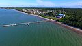
Cedros
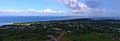
La Brea

South Oropouche


Web links
- Siparia Regional Corporation website
Individual evidence
- ↑ Development Report of Siparia Regional Corporation, p. 7. (No longer available online.) Archived from the original on July 31, 2015 ; Retrieved July 6, 2015 . Info: The archive link was inserted automatically and has not yet been checked. Please check the original and archive link according to the instructions and then remove this notice.
- ↑ Trinidad's administrative history. (No longer available online.) Archived from the original on April 11, 2015 ; Retrieved April 5, 2015 . Info: The archive link was inserted automatically and has not yet been checked. Please check the original and archive link according to the instructions and then remove this notice.
| Regions |
Couva-Tabaquite-Talparo | Diego Martin | Mayaro-Rio Claro | Penal Debe | Princes Town | San Juan Laventille | Sangre Grande | Siparia | Tunapuna-Piarco |
|
| Boroughs | ||
| Cities | ||
| Ward |
