Couva-Tabaquite-Talparo
| Couva-Tabaquite-Talparo | |
|---|---|
| Basic data | |
| Country | Trinidad and Tobago |
| Capital | Couva |
| surface | 719.6 km² |
| Residents | 178,410 (2011) |
| density | 248 inhabitants per km² |
| ISO 3166-2 | TT-CTT |
| politics | |
| Chairman | Henry Awong |
| Political party | UNC |
Coordinates: 10 ° 25 ′ N , 61 ° 27 ′ W
Couva-Tabaquite-Talparo is a region and administrative unit in Trinidad in Trinidad and Tobago .
geography
Couva-Tabaquite-Talparo is located in central Trinidad. Starting in the northwest it is surrounded clockwise by Chaguanas , Tunapuna-Piarco , Sangre Grande , Mayaro-Rio Claro , Princes Town and San Fernando . To the west it borders the Gulf of Paria . The capital of the region is Couva .
Significant cities and towns in Couva-Tabaquite-Talparo are:
- Couva (16,466 inhabitants, as of 2011)
- Gasparillo (9,596, 2000)
- Tabaquite (3,314, 2005)
- Claxton Bay
- Point Lisas
- Pointe-à-Pierre
- St. Mary's
- Talparo
Economy and Infrastructure
Point Lisas is home to the industrial areas of Point Lisas Industrial Estate and Port of Point Lisas , the second largest port in the country, managed by PLIPDECO (Point Lisas Industrial Port Development Company) . Here is the center of the Trinidian heavy industry, e.g. B. an ArcelorMittal steelworks , factories for the production of methanol , ammonia and urea, two power plants and a large desalination plant. The energy for the industrial area is generated in natural gas fields off the east coast of Trinidad. The oil refinery of Petrotrin , a state oil company, is located in Pointe-à-Pierre . The United National Congress (UNC), one of the two major parties in Trinidad, has its headquarters in the Rienzi Complex in Couva.
In the southeast of Couva is the Port Lisas Campus , a branch of the University of Trinidad and Tobago .
The Southern Main Road, the most important north-south traffic axis of Trinidad, runs through Couva-Tabaquite-Talparo and connects all major cities. From 1880 to 1968, the region was connected to the Trinidad Government Railway , the Trinidian railway system. There was a station in Tabaquite and an end stop in Couva. The advent of the automobile coupled with the island's small size led to the closure of the system. In Couva is the Camden Airstrip, an airfield without an IATA code that was used for agricultural flights at the time of Caroni (1975) Limited and for which there are vague plans for expansion.
Culture
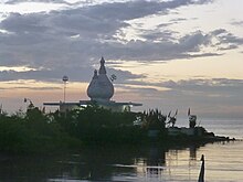
In Carapichaima on the Gulf coast there are two Hindu sanctuaries: A Dattatreya temple with a 30 meter high Hanuman statue and the "Temple in the Sea", a Shiva temple that is built into the sea and connected to the land by means of a pier and in the vicinity of which one of the country's three religious cremation facilities is located. Hinduism is the predominant religion in Trinidad's former sugar cane belt.
history
Until 1990 Trinidad was divided into counties . As part of an administrative reform (Municipal Corporations Act No. 21), all counties were dissolved in 1990 and new administrative units were created. Parts of the Counties Caroni and Victoria became Couva-Tabaquite-Talparo.
Individual evidence
- ↑ Citypopulation.de
- ↑ PTSC.co.tt: Public Transport Service Corporation - About Us ( Memento of 10 April 2013, Internet Archive )
- ^ Mark Fraser: Airport for Central . In: Trinidad Express . May 24, 2011.


