
San Fernando (Trinidad and Tobago)
| City of San Fernando San Fernando |
|||
|---|---|---|---|
|
|||
| Coordinates | 10 ° 16 '59 " N , 61 ° 27' 31" W | ||
| Basic data | |||
| Country | Trinidad and Tobago | ||
| San Fernando | |||
| ISO 3166-2 | TT-SFO | ||
| surface | 18.6 km² | ||
| Residents | 48,838 (2011 Census) | ||
| density | 2,620.1 Ew. / km² | ||
| founding | 1792 | ||
| politics | |||
| mayor | Junia Regrello | ||
| Political party | PNM | ||
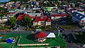
 view on the city
|
|||

With an area of 18 km², San Fernando is the second largest city in Trinidad and is located in the southwestern part of the island. Several rivers flow through San Fernando, including the Guaracara in the north and the South Oropouche River in the south; to the west is the Gulf of Pariah . The population in San Fernando is around 50,000.
geography
San Fernando, called "Sando" by the locals, is a coastal town 55 km south of Port of Spain . There are two major highways around San Fernando, the Southern Main Road and the Solomon Hochoy Highway .
The city originally lay on the flanks of two hills, San Fernando Hill and Alexander Hill.
history

In 1783, the Spanish minister responsible for Trinidad, José de Gálvez y Gallardo, issued the Cedula de populacion , an edict that allowed the increased settlement of Catholic, especially French, citizens on the Spanish island of Trinidad until 1797, thereby allowing a significant increase in population and a rapidly increasing economic performance of the island made possible. As part of this edict, the French Isidore Vialva came to Trinidad and was allocated land in the area of today's San Fernando, part of which was earmarked for a later settlement. Contrary to the provisions of the leasing contract, he sold the reserved part of the land to his compatriot Jean-Baptiste Jaillet, who parceled parts of the land and sold it to smallholders who settled there and thus founded a settlement that is illegal under Spanish law. Governor José María Chacón did not become aware of this until 1792. Chacón pragmatically recognized the settlement and named it after Ferdinand , son of the then Spanish King Charles III . Jaillet and subsequently other settlers built lucrative sugar cane plantations in the vicinity of the place. In 1818, San Fernando was destroyed by a major fire, but rebuilt. In addition to the sugar cane industry, cocoa cultivation and processing, as well as the oil industry from the 1910s onwards, helped San Fernando to achieve economic success. In 1882 the city was connected to the railway network of the Trinidad Railway Company. Between the Second World War and the 1980s, the largest oil refinery in the Caribbean was built in San Fernando. In 1991, the city's borders continued to expand to include the suburbs of Marabella, Bel Air, Gulf View and Cocoyea.
politics
The city is administered by the San Fernando City Corporation . Local government in San Fernando began in 1845 when the city council was established. The first mayor of San Fernando was Dr. Robert Johnstone. Due to the economic success of that time, the village became the third largest city in Trinidad today.
economy
After the boom in 1783, San Fernando is still referred to as the "industrial capital". The Pointe-à-Pierre refinery made the city heavily dependent on oil production. Nearby is Point Lisas, a rapidly growing industrial zone with petrochemical plants, a steel mill and a modern container port. San Fernando is also the trading center for southern Trinidad.
media
San Fernando has regional offices for the daily newspapers Trinidad Guardian , Trinidad Express and Trinidad Newsday as well as the weekly newspapers TnT Mirror , Sunday Punch and Showtime . The national radio stations WACK 90.1 and Heritage Radio are located in the city.
Sports
San Fernando is home to the Brian Lara Cricket Academy cricket stadium, which is suitable for international competitions, and the Skinner Park Velodrome, one of three cycling arenas in Trinidad.
Attractions

One of the most famous places in San Fernando is San Fernando Hill, formerly also called Naparimo Hill. It used to be the highest point in San Fernando, but it has now been converted into a public park. The Harris Promenade is also worth seeing, where there are many sights, including the town hall, the old police station and St. Paul's Church.
The largest shopping metropolis in South Trinidad is the High Street. It was built on the model of American shopping malls and is an important source of income for the island nation.
Churches: There are numerous sacred institutions in San Fernando. Three protrude from the Christian buildings:
- Notre Dame de Bon Secours
- St. Paul's Church
- Cathedral of Our Lady of Perpetual Help
The latter was consecrated as a Catholic church in 1849.
Cultural and scientific institutions:
- Monument to Mahatma Gandhi on Harris Promenade
- Marcus Garvey statue, also on Harris Promenade
- Naparima Bowl, the city's cultural center that hosts concerts and exhibitions
Important political building
- City Hall: San Fernando City Hall which is on Harris Promenade.
sons and daughters of the town
- Michel-Jean Cazabon (1813–1888), painter
- Lord Invader (1914–1961), calypso singer
- Noor Hassanali (1918-2006), politician
- Samuel Selvon (1923-1994), writer
- Rodney Wilkes (1925-2014), weightlifter
- Ferdi de Gannes (1929–2018), racing cyclist
- George Maxwell Richards (1931-2018), politician
- Basdeo Panday (* 1933), politician
- Patrick Manning (1946–2016), politician
- Hasely Crawford (born 1950), athlete
- Stephen Ames (born 1964), PGA tour golfer
- Teresa Lourenço (* 1981), German photo model
- Jlloyd Samuel (1981-2018), football player
- Krystle Esdelle (* 1984), volleyball player
- Haseem McLean (* 1987), cyclist
- Njisane Phillip (* 1991), racing cyclist
gallery

Carnegie Free Public Library

port
town hall
.jpg)

.jpg)
Web links
Individual evidence
- ↑ Michael Anthony: Historical Dictionary of Trinidad and Tobago . Scarecrow Press, London 1997, ISBN 0-8108-3173-2 , pp. 594 .
- ↑ Michael Anthony: Towns and Villages of Trinidad and Tobago . 2nd Edition. Printmaster, Marabella 2001, p. 249 .
- ^ San Fernando , on Encyclopædia Britannica online.
- ↑ PTSC.co.tt: About Us ( Memento from April 10, 2013 in the Internet Archive )
- ↑ Isport.com: Cycling Velodromes in Trinidad And Tobago. Retrieved February 18, 2016 .
| Regions |
Couva-Tabaquite-Talparo | Diego Martin | Mayaro-Rio Claro | Penal Debe | Princes Town | San Juan Laventille | Sangre Grande | Siparia | Tunapuna-Piarco |
|
| Boroughs | ||
| Cities | ||
| Ward |
