Chaguanas
| Chaguanas | ||
|---|---|---|
|
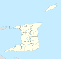
Coordinates: 10 ° 30 ′ N , 61 ° 23 ′ W Chaguanas on the map of Trinidad and Tobago
|
||
| Basic data | ||
| Country | Trinidad and Tobago | |
| Borough | Chaguanas | |
| Residents | 83,516 (2011) | |
| Detailed data | ||
| surface | 59.65 km 2 | |
| Population density | 1400 inhabitants / km 2 | |
| height | 18 m | |
| City structure | 19th | |
| Waters | Caparo River | |
| Time zone | UTC −4 | |
| City Presidency | Gopaul Boodhan | |
| Website | ||
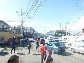
| Chaguanas Main Road | ||
Chaguanas is a city in Trinidad and Tobago . As a borough , it forms an independent administrative unit, comparable to a German urban district . It is the largest city in the island state in terms of population.
location
Chaguanas is located in central Trinidad, about 18 kilometers south of the capital Port of Spain . The city is formally located on the Gulf of Paria , but is separated from it by an uninhabited, approximately one kilometer wide, southern branch of the Caroni Swamp . Geographically, the urban area is located on the western edge of the Caroni Plain , a lowland plain that runs through half of the island in a west-east direction and is bounded by the Northern Range and the Central Range. The Cunupia River and the Caparo River flow through Chaguanas towards the Gulf and for a long time formed the northern and southern borders of the city. The Borough Chaguanas borders on three administrative regions: San Juan-Laventille in the northwest, Tunapuna-Piarco in the northeast and Couva-Tabaquite-Talparo in the east and south.
history
The name “Chaguanas” was given to the area by Spanish settlers, but it goes back to the “Chaguanes”, an Indian tribe that lived in the region in pre-Columbian times. Settlement of the area during the Spanish colonial rule from 1592 to 1797 has not been proven. After the British conquered Trinidad in 1797, large areas of sugar cane and cocoa were grown in what is now the settlement area; After a few years there was already a sugar refinery of the Woodford family, a sugar cane plantation of the Robinson family and a coconut and cocoa plantation of the de Verteuil family. The connection to Port of Spain and San Fernando was initially (and until 1928) by ship, but in the 1860s a road to Port of Spain was built. From 1880 to the middle of the 20th century Chaguanas was connected to the then existing railway network of Trinidad, specifically to the connection Port of Spain-Rio Claro, which gave the city another economic boom. From 1941 to 1949 the southern part of Chaguanas was Carlsen Air Force Base, a US air force base that was awarded to the USAAF as part of the much-criticized destroyer-for-base agreement . After 1949 the land was converted to agricultural land, most of which is farmed by National Flour Mills. Until 1990 Trinidad was divided into counties , Chaguanas belonged to County Caroni. As part of an administrative reform (Municipal Corporations Act No. 21), all counties were dissolved in 1990 and new administrative units were created, while Chaguanas was converted into its own borough due to its size.
| year | Residents |
|---|---|
| 1980 | 6,177 |
| 1988 | 8,000 |
| 2000 | 67,433 |
| 2011 | 83,516 |
Until the late 1980s, Chaguanas was a small town with less than 10,000 inhabitants. Then, however, rapid growth set in, for which there are essentially two reasons. On the one hand, the construction of several shopping malls began, through which Chaguanas presented itself as the commercial center of the island, an image that has been preserved to this day. On the other hand, the building land in Chaguanas was cheap, which made the city attractive as a place to live for residents of Port of Spain and San Fernando. Statistics show that the rapid growth of Chaguanas essentially corresponds with declining population numbers in Port of Spain and San Fernando. A factor underlying both of these points is the increase in purchasing power associated with the oil boom of the 1970s and 1980s.
Economy and Transport
Chaguanas is a transport hub in central Trinidad. The two major north-south highways meet in the middle of the city: the Uriah Butler Highway coming from Port of Spain ends in Chaguanas, the Sir Solomon Hochoy Highway begins here and leads to San Fernando in the south. Due to its central location and good transport connections, the city is the commercial center of central Trinidad, which is manifested by the offices of numerous domestic and foreign banks and four large shopping malls. Due to the unplanned and uncontrolled growth of the city since the 1980s, Chaguanas suffers from high traffic volumes.
Due to its location in the central lowlands, Chaguanas has always been an agricultural center. In the years prior to 2003, the agricultural sector was dominated by Caroni (1975) Limited , a state-owned conglomerate with a focus on sugar production and processing. An economic and historical setback for Chaguanas as well was the liquidation of the group by the then Trinidadian government in 2003. Alston Building Enterprises, the largest Caribbean manufacturer of bricks, windows and doors, is based in Chaguanas, as is Chief Brand Products , the largest manufacturer of spices and condiments in the Caribbean and the Kiss Baking Company , the largest Trinidadian manufacturer of packaged baked goods.
Administration, politics and public institutions
Trinidad and Tobago is divided into three different administrative units based on the British system: "Cities", "boroughs" and "regional corporations", in Germany comparable to city-states , independent cities and federal states. Chaguanas has the status of a "borough", the administrative legal upgrading to a "city" is being discussed because of the rapid population growth. Chaguanas is divided into eight constituencies:
- Felicity / Endeavor
- Enterprise South
- Edinburgh / Longdenville
- Enterprise North
- Charlieville
- Montrose
- Monroe Road / Caroni Savannah Road
- Cunupia
The smallest administrative unit in Trinidad and Tobago is the "community", comparable to a city or district. Chaguanas is divided into 19 communities:
| Community | Residents |
|---|---|
| Enterprise | 14,434 |
| Munroe Settlement | 1,646 |
| Jerningham Junction | 4,816 |
| Esmeralda | 1,972 |
| Homeland Gardens | 1,764 |
| Lendore Village | 1,809 |
| Felicity | 7,641 |
| St. Charles Village | 5,320 |
| Endeavor Village | 4,449 |
| Edinburgh 500 | 8,462 |
| Edinburgh Gardens | 937 |
| Long park | 4,042 |
| Petersfield | 1,180 |
| Chaguanas Proper | 2,610 |
| St. Thomas Village | 335 |
| Montrose Village | 4,298 |
| Charlieville | 7,462 |
| Cunupia | 3,225 |
| Longdenville | 7,100 |
| total | 83,516 |
A campus of the University of Trinidad and Tobago is located in Chaguanas. Another educational facility is the Sugarcane Feeds Center, a government agricultural research and training facility.
Enterprise-based football club Crown Trace FC won the 2014 FIFA Power of Football competition , an award for people or organizations who have a positive impact on their environment through football.
There is a city partnership with Lauderhill (USA).
Personalities
- VS Naipaul (1932-2018, writer)
- Jacey Harper (* 1980, athlete)
Individual evidence
- ^ Speech by VS Naipaul on the occasion of the Nobel Prize for Literature awarded to him, 2001. Accessed on December 13, 2014 .
- ↑ Michael Anthony: Towns and Villages of Trinidad and Tobago, p. 48. Printmaster 2001.
- ↑ 2000 census
- ↑ 2011 census
- ↑ Analysis of a local real estate company. Retrieved January 4, 2015 .
- ^ Report of the Central Statistical Office from 2011. (PDF) Retrieved on April 8, 2018 .
- ↑ Article in the Trinidad Guardian of July 31, 2003, available online
- ^ Kiss Baking Co. BGL Bermudez Group Ltd., 2015, accessed on June 30, 2015 (English).
- ↑ Trinidad Express of July 18, 2014, available online ( Memento of January 4, 2015 in the Internet Archive )
- ↑ including 13 officially registered "street dwellers"
- ↑ The Power of Football Contest on FIFA.com. Retrieved July 5, 2015 .


