Pointe de Zinal
| Pointe de Zinal | ||
|---|---|---|
|
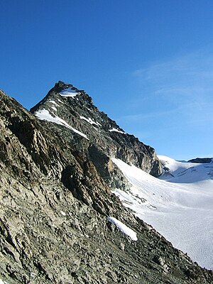
Pointe de Zinal from the south, near the Upper Blausatz |
||
| height | 3789 m above sea level M. | |
| location | Canton of Valais , Switzerland | |
| Mountains | Valais Alps | |
| Dominance | 0.93 km → Dent Blanche | |
| Notch height | 301 m ↓ Col de Zinal | |
| Coordinates | 614 864 / 97300 | |
|
|
||
| Normal way | Northeast ridge of Col Durand ( II ) | |
The Zinalspitze (or in the more common French name Pointe de Zinal ) is a 3789 m high double peak in the Valais Alps and lies southeast of the Dent Blanche ( 4357 m ). The higher north summit is separated from the south summit ( 3778 m ) by a connecting ridge about 300 meters long. The summit sends out three ridges: to the northwest to Dent Blanche, from which the Pointe de Zinal is separated by the Col de Zinal ( 3490 m ), to the south to the Schönbielhorn , and to the northeast to Mont Durand . The latter becomes the Arbengrat , which leads to the Obergabelhorn ( 4063 m ), the deepest notch is the Col Durand ( 3438 m ). To the northeast of the mountain lies Glacier Durand , to the southwest the Schönbiel glacier and to the southeast the Hohwäng glacier . The summit is somewhat overshadowed by its better-known and higher neighbors, the Dent Blanche and the Obergabelhorn.
Climbs
The usual ascent leads from Col Durand ( 3438 m ) over the northeast ridge. Firn and rock alternate. The last few meters require block climbing. The Col Durand is usually reached from the Schönbielhütte via the notch between Schönbielhorn and Gemsspitz (Oberer Blausatz, 3209 m ) and the Hohwäng glacier. Allow around 3 hours from the hut to Col Durand and around 1½ hours for the northeast ridge.
The southern summit can be reached via the southern ridge. This can either be reached from the Obere Blausatz by crossing the western flank of the Schönbielhorn at the deepest notch ( 3358 m ). Alternatively, you can cross the Schönbielhorn with an additional time investment of about 45 minutes to get into this gap. The transition from the south to the higher north summit requires climbing in the III. Difficulty level , with two ridge towers to be climbed. You should plan around four hours from the Schönbielhütte to the south summit, and another hour for the transition to the north summit.
Literature and map
- Michael Waeber: Area Guide Valais Alps . 13th edition, Bergverlag Rother , Munich 2003, ISBN 3-7633-2416-X .
- Hiking map 1: 25,000, Zermatt . 2008, Rotten Verlag, ISBN 978-3-905756-46-3 (map base: national maps of Switzerland 1: 25,000)

