Ponale
| Ponale | ||
|
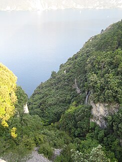
Valley cut Ponale rivers before flowing into Lake Garda from the Ponale road from. An inflow over a waterfall can be seen on the right. |
||
| Data | ||
| location | Trentino , Italy | |
| River system | Po | |
| Drain over | Mincio → Po | |
| River basin district | Padano | |
| source |
Lake Ledro 45 ° 52 ′ 27 ″ N , 10 ° 45 ′ 52 ″ E |
|
| Source height | 655 m slm | |
| muzzle |
Lake Garda coordinates: 45 ° 51 ′ 41 ″ N , 10 ° 49 ′ 58 ″ E 45 ° 51 ′ 41 ″ N , 10 ° 49 ′ 58 ″ E |
|
| Mouth height | 65 m slm | |
| Height difference | 590 m | |
| Bottom slope | 84 ‰ | |
| length | 7 km | |
The Ponale is a 7 km long mountain stream that rises in Lake Ledro ( Lago di Ledro ) and flows into Lake Garda .
From Lake Ledro, the stream first flows through Molina di Ledro , Prè di Ledro and Biacesa di Ledro with a medium gradient. There he also feeds a trout farm.
From Biacesa to Lake Garda, the valley is deeply cut and the stream runs over a waterfall and flows into Lake Garda at the old port of Antico Porto del Ponale . In 1439, the port was the destination of the Venetian fleet set sail from Torbole , which had previously been transported from the Adige Valley to Lake Garda by the company Galeas per montes, designated by the Republic of Venice .
