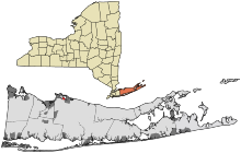
Poquott
| Poquott | |
|---|---|
|
Location in Suffolk County (New York)
|
|
| Basic data | |
| State : | United States |
| State : | new York |
| County : | Suffolk County |
| Coordinates : | 40 ° 57 ′ N , 73 ° 5 ′ W |
| Time zone : | Eastern ( UTC − 5 / −4 ) |
| Residents : | 953 (as of 2010) |
| Population density : | 866.4 inhabitants per km 2 |
| Area : | 1.5 km 2 (approx. 1 mi 2 ) of which 1.1 km 2 (approx. 0 mi 2 ) is land |
| Height : | 9 m |
| Postal code : | 11733 |
| Area code : | +1 631 |
| FIPS : | 36-59157 |
| GNIS ID : | 2391073 |
| Website : | www.poquott.org |
Poquott is a place on the north coast of Long Island in the US state of New York . It has the status of a incorporated village (self-governing village) within the Town of Brookhaven in Suffolk County . According to the 2010 census, the village had 953 inhabitants.
geography
Poquott has an area of 1.5 km², of which 1.1 km² is land and 0.4 km² is water. It is located on a headland that separates the Setauket Harbor side bay from Port Jefferson Harbor , which in turn is a side bay of Long Island Sound . It borders Setauket-East Setauket to the south and Port Jefferson to the east .
The place consists exclusively of a loosely built residential area.
history
The year of foundation, i.e. the time of the first development by European settlers, is 1659. The place was initially called George's Neck after a George Wood, who on July 23, 1662 opened a tavern for the nearby Setauket settlement on the bank. The first official mention in the city archives dates from January 6, 1668. The current place name comes from an Indian expression for free or cleared land . In 1679 the area was divided into parcels, on which the later development was based. In the British-American War a little was here in 1812 Fort built. In 1931 the village was incorporated.
Infrastructure
Poquott only has smaller local roads and no connections to train or bus routes.
