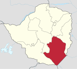
Masvingo Province
| Masvingo Masvingo Province
|
|
|---|---|
 |
|
| Basic data | |
| Country | Zimbabwe |
| Capital | Masvingo |
| surface | 56,566 km² |
| Residents | 1,485,090 (2012) |
| density | 26 inhabitants per km² |
| ISO 3166-2 | ZW-MV |
Coordinates: 21 ° 0 ′ S , 31 ° 0 ′ E
Masvingo is a province in southeast Zimbabwe . It covers an area of 56,566 square kilometers with a population of 1,485,090 people (2012). It is named after its capital Masvingo .
The province is dominated by the Karanga tribe, who belong to the Shona . It is part of the semi-arid lowlands, which offers favorable conditions for cattle breeding. Outside of the rainy season, the area is dusty and dry.
Essentially, there are open forests with grasslands and granite hills. There is also some mining and sugar cane cultivation , which is irrigated by the Mukurikwi River. The province borders Mozambique to the east and the Kruger National Park in South Africa to the south .
Gonarezhou National Park lies along the border with Mozambique .
Districts
Masvingo consists of seven districts.
- Bikita
- Chiredzi
- Chivi
- Gutu
- Masvingo
- Mwenezi
- Zaka
Geographical location
| Midlands Province | Midlands Province | Manicaland Province |
| Midlands Province |

|
Manicaland Province |
| Matabeleland South Province | South Africa | Mozambique |
Individual evidence
- ↑ ZimStat : Zimbabwe Population Census 2012. (pdf) October 2013, accessed on September 7, 2019 (English).
