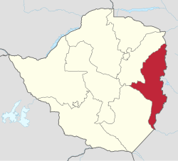
Manicaland Province
| Manicaland Province | |
|---|---|
 |
|
| Basic data | |
| Country | Zimbabwe |
| Capital | Mutare |
| surface | 36,459 km² |
| Residents | 1,752,698 (2012) |
| density | 48 inhabitants per km² |
| ISO 3166-2 | ZW-MA |
Coordinates: 19 ° 0 ′ S , 32 ° 30 ′ E
Manicaland is a province in eastern Zimbabwe . It has an area of 36,459 km² and a population of 1,752,698 people (as of 2012), which makes up 13.4 percent of the total population of Zimbabwe. In the province of Manicaland is also the highest mountain in the country, the Inyangani with 2596 m.
The capital of the province is Mutare . The province itself is divided into seven districts and three municipal councils :
- Buhera
- Chimanimani with the place Chimanimani
- Chipinge Rural
- Chipinge Urban
- Makoni Rural
- Makoni Urban
- Mutare Rural
- Mutare Urban
- Mutasa
- Nyanga (with the town of Nyanga )
The province got its name from the Manyika, a subgroup of the Shona with their own language, who settled in the area.
history
The British colony of Manikaland was similar in location to today's province, but smaller.
Geographical location
| Mashonaland East | Mashonaland East | Mozambique |
| Midlands Province |

|
Mozambique |
| Masvingo Province | Masvingo Province | Mozambique |
Individual evidence
- ↑ ZimStat : Zimbabwe Population Census 2012. (pdf) October 2013, accessed on September 7, 2019 (English).