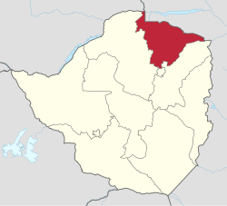
Mashonaland Central Province
| Mashonaland Central Mashonaland Central Province
|
|
|---|---|
 |
|
| Basic data | |
| Country | Zimbabwe |
| Capital | Bindura |
| surface | 28,347 km² |
| Residents | 1,152,520 (2012) |
| density | 41 inhabitants per km² |
| ISO 3166-2 | ZW-MC |
Coordinates: 17 ° 0 ′ S , 31 ° 0 ′ E
Mashonaland Central (German Zentralmaschonaland ) is a province in northeast Zimbabwe . It is 28,347 km² and is home to 1,152,520 (2012) inhabitants, about 8.8 percent of the total population of the country. Bindura is the capital of the province.
Mashonaland Central is divided into eight districts:
- Bindura
- Guruve
- Mazowe
- Mbire
- Mount Darwin
- Muzarabani
- Rushinga
- Shamva
Geographical location
| Zambia | Mozambique | Mozambique |
| Mashonaland West |

|
Mashonaland East |
|
Mashonaland West / Harare |
Mashonaland East | Mashonaland East |
Individual evidence
- ↑ ZimStat : Zimbabwe Population Census 2012. (pdf) October 2013, accessed on September 7, 2019 (English).