Pschisch
|
Pschisch Пшиш |
||
| Data | ||
| Water code | RU : 06020001212108100005119 | |
| location | Krasnodar Region , Adygea ( Russia ) | |
| River system | Kuban | |
| Drain over | Kuban → Black Sea | |
| Confluence of |
Bolschoi Pshish River and Maly Pshish River 44 ° 10 '38 " N , 39 ° 30' 23" O |
|
| muzzle |
Krasnodar Reservoir Coordinates: 44 ° 59 ′ 52 " N , 39 ° 24 ′ 25" E 44 ° 59 ′ 52 " N , 39 ° 24 ′ 25" E
|
|
| length | 258 km (including the headwaters of the Bolshoi Pschisch 270 km) | |
| Catchment area | 1850 km² | |
| Drain |
MQ |
25 m³ / s |
| Small towns | Chadyshensk | |
|
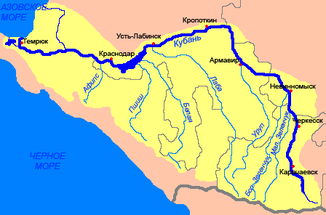
Location of the Pschisch (Пшиш) in the catchment area of the Kuban |
||
The Pschisch ( Russian Пшиш ) is a left tributary of the Kuban in the Stavropol region and in the Adygea republic in the North Caucasus .
The Pschisch arises at the confluence of its two source rivers, Bolshoi Pschisch and Maly Pschisch , on the northern flank of the Greater Caucasus . Initially it flows through the mountains in a narrow, deep valley. It flows through the city of Chadyshensk . When you leave the mountainous area, the river valley widens. The Pschisch flows through the area of the Republic of Adygea in the lower reaches and flows into it on the south bank of the Krasnodar reservoir , through which the Kuban flows. The Pschisch has a length of 258 km. It drains an area of 1850 km². The mean discharge is 25 m³ / s. In the event of a flood , discharge of 1000 m³ / s can occur.
Individual evidence
- ↑ a b Pschisch in the State Water Directory of the Russian Federation (Russian)
- ↑ a b c d Article Pschisch in the Great Soviet Encyclopedia (BSE) , 3rd edition 1969–1978 (Russian)

