
Puymangou
| Puymangou | ||
|---|---|---|
|
||
| local community | Saint Aulaye-Puymangou | |
| region | Nouvelle-Aquitaine | |
| Department | Dordogne | |
| Arrondissement | Périgueux | |
| Coordinates | 45 ° 12 ′ N , 0 ° 5 ′ E | |
| Post Code | 24410 | |
| Former INSEE code | 24343 | |
| Incorporation | January 1, 2016 | |
| status | Commune déléguée | |
 Town hall (Mairie) of Puymangou |
||

Puymangou is a village and a former French commune with a population of 70 (as at 1st January 2017) in the department of Dordogne in the region Nouvelle-Aquitaine . It belonged to the Arrondissement of Périgueux and the canton of Saint-Aulaye .
With effect from January 1, 2016, the former municipalities of Saint-Aulaye and Puymangou were merged into a nouvelle commune called Saint Aulaye-Puymangou . The former municipalities have the status of a Commune déléguée in the new municipality . The administrative headquarters are in Saint-Aulaye.
location
Puymangou is about sixty kilometers west of Périgueux .
Population development
| year | 1962 | 1968 | 1975 | 1982 | 1990 | 1999 | 2006 | 2013 |
| Residents | 134 | 147 | 119 | 98 | 99 | 101 | 96 | 96 |
| Source: Cassini and INSEE | ||||||||
Attractions
- Saint-Étienne church, former priory from the 10th century
- Puymangou Castle from the 17th century
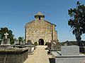
Saint-Etienne church
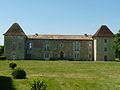
Puymangou Castle


Web links
Commons : Puymangou - collection of images, videos and audio files