Qafa e Buallit
| Qafa e Buallit | |||
|---|---|---|---|
|
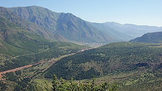
The pass seen from the southwest with Bulqiza in the background |
|||
| Compass direction | west | east | |
| Pass height | 842 m above sea level A. | ||
| circle | Mat | Dibra | |
| Watershed | fan | Inside | |
| Valley locations | Toilets | Maqellara | |
| expansion | Street | ||
| Lock | - | ||
| particularities | Passort Bulqiza just east of the pass road tunnel under construction (2011) |
||
| map | |||
|
|
|||
| Coordinates | 41 ° 28 ′ 55 " N , 20 ° 11 ′ 45" E | ||
The Qafa e Buallit ( German : Buffalo Pass ) is 842 m above sea level. A. high mountain pass in Albania . The national road SH 6 , which connects the Albanian coast with the Mat and Dibra region, leads over the pass. The pass lies on the watershed between the Mat rivers to the west and Drin to the east. Bulqiza is located just east of the top of the pass .
A new pass road, the so-called Rruga e Arbërit, has been built for several years . The SH 6 between Bulqiza and the Drin had already been expanded into a wide, two-lane road in 2011; Work was being carried out on the Bulqiza bypass and the continuation to the west. The pass is crossed under a 465 meter long tunnel. The west ramp of Klos is getting a new route. The Rruga e Arbërit is supposed to provide a direct connection between Tirana and the Macedonian border, which saves the detour via Milot and Burrel . Additional tunnels and large bridges are necessary for the direct passage through the mountains between Tirana and Klos. The work was temporarily suspended. In the summer of 2016, there was hardly any progress in the construction work to be seen on current satellite images from Google Earth. Only the Bulqiza bypass was completed, and a new ramp now connects it from below the east portal of the tunnel with the top of the pass.
At the top of the pass, a road branches off to the southwest to the village of Krasta in the Martanesh area.
The Qafa e Buallit is located in a region with many mines, which the city of Bulqiza has as its center. A large drivable tunnel in these mines crosses the pass at a height of just over 700 meters.
Individual evidence
- ^ Albanian military map, 1987
- ↑ Bujar Karoshi: Punimet fillojnë, ndërsa kontrata nuk është firmosur akoma. In: Rrugaearberit.com. December 31, 2017, Retrieved February 25, 2019 (Albanian).
- ↑ Rruga e Arbrit gati në vitin 2013. In: YllPress. August 16, 2010, accessed July 27, 2011 (Albanian).
- ↑ Google Earth. July 20, 2016, accessed December 10, 2016 .


