Rruga shtetërore SH6
| Rruga shtetërore / Rrugë shtetërore SH6 in Albania | |

|
|
| map | |
| Basic data | |
| Operator: | Autoriteti Rrugor Shqiptar |
| Start of the street: |
Milot ( 41 ° 42 ′ N , 19 ° 47 ′ E ) |
| End of street: |
Peshkopia ( 41 ° 41 ′ N , 20 ° 26 ′ E ) |
|
Qarqe : |
|
|
Course of the road
|
|
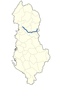
The Rruga shtetërore SH6 ( Albanian for state road SH6 ) is a national road in Albania and leads from Milot to Peshkopia .
Routing
The SH6 branches off from the SH1 at Milot and leads via Burrel and Bulqiza to Peshkopia .
In the first part between Milot and Klos the road runs in the valley of the river Mat , first in a narrow valley cut through the Skanderbeg mountains, north of Burrel in the Matsenke, often in the hill country far from the river. From Klos, the SH6 quickly climbs around 550 meters to the Qafa e Buallit pass at 842 m above sea level. A. at. To the east it follows the Bulqiza valley to the Drin , which it crosses in a narrow gorge. At Maqellara there is a branch to Debar in North Macedonia . From here the road leads north to Peshkopia, again in the hill country far from the river.
Between Bulqiza and the Drin , the SH6 has been expanded into a wide, two-lane road. The Rruga e Arbërit project is currently (2011) under construction on the Bulqiza bypass and further west . The new road is intended to provide a direct connection between Tirana and the North Macedonian border, which will save the detour via Milot and Burrel. The Qafa e Buallit pass is crossed under a 465 meter long, already drilled tunnel. Numerous further tunnels and complex bridges are necessary for the passage through the mountains between Tirana and Klos .
In Maqellarë a new bypass road was built and renewed the road towards Peshkopi several kilometers.
Web links
Individual evidence
- ↑ Bujar Karoshi: Punimet fillojnë, ndërsa kontrata nuk është firmosur akoma. In: Rrugaearberit.com. December 31, 2017, Retrieved February 25, 2019 (Albanian).
- ↑ Rruga e Arbrit gati në vitin 2013. In: YllPress. August 16, 2010, accessed July 27, 2011 (Albanian).

