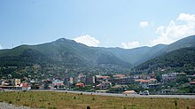
Milot (Albania)
| Milot | ||
|
Coordinates: 41 ° 41 ′ N , 19 ° 43 ′ E |
||
| Basic data | ||
|---|---|---|
| Qark : | Lezha | |
| Municipality : | Kurbin | |
| Height : | 25 m above sea level A. | |
| Area : | 111.7 km² | |
| Residents : | 8461 (2011) | |
| Population density : | 76 inhabitants / km² | |
| Postal code : | 4705 | |
Milot ( Albanian also Miloti ) is a small town in the municipality Kurbin in the Qark Lezha in northern Albania . The place has around 3000 inhabitants. Milot is around 41 kilometers from the capital Tirana on the way to Shkodra .
Until 2015 Milot was an independent municipality ( komuna ), which had 8461 inhabitants in 2011. The local authorities even stated 13,500 inhabitants, with less than two thirds of the families living in the 13 associated villages.
Milot lies on the eastern edge of the coastal plain. Here the river Mat emerges from the mountains in a cut through the Skanderbeg Mountains and crosses the coastal plain in a wide bed. The town on the south bank of the river stretches up the mountain slopes in its foothills.
The place is an important traffic junction for the whole of northern Albania: The bridges near Milot connect the northwest with the rest of the country, on the other hand roads branch off to eastern and northeastern Albania: The Mat valley serves as access to the mountainous regions of northeast Albania with roads into the Mirdita and further to the regions of Kukës , Has and Tropoja as well as to Mat and further to Bulqiza and Peshkopia . Three bridges, one of which road and rail combined result, today in Milot over the river - the oldest bridge in 1927 created Zogu bridge , was the first major steel arch bridge Albania.
A new expressway ( SH1 ) a few kilometers west of the plain has relieved the town of through traffic on the north-south route since the beginning of the millennium. The new A1 motorway branches off from this at Milot and has led to Kukës and Kosovo since June 2009 . The route bypasses Milot in a narrow strip between the outskirts and the southern bank of the Mats.
The route of the Albanian railways Hekurudha Shqiptare to Shkodra also runs through Milot. A branch route into the hinterland was closed, the route via Rubik to Rrëshen was used for the construction of the motorway.
Web links
Individual evidence
- ↑ Ines Nurja: Censusi i popullsisë dhe banesave / Population and Housing Census - Lezhë 2011 . Results Kryesore / Main Results. Ed .: INSTAT . Pjesa / Part 1. Adel Print, Tirana 2013 ( instat.gov.al [PDF; accessed April 14, 2019]).
- ↑ Njesia administrative Milot. (PDF) In: Këshilli i Qarkut Lezhë. January 2012 Retrieved on April 29, 2019 (Albanian).
- ↑ Albert Ramaj: The Albanians in Switzerland , in: Albsuisse , Volume 2, No. 6, June 2009
- ↑ Erwin Schnitter: The construction of the “Ura-Zogu” road bridge over the Mati River in Albania . In: Schweizerische Bauzeitung , 91/92 (1928) doi: 10.5169 / seals-42536
- ^ The unfinished route: Milot - Rrëshen - Burrel - Klos (part 1, 28 B.). In: turntable online. September 24, 2011, accessed January 10, 2012 .


