
Fan (river)
| fan | ||
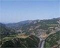
 The fan valley near Rubik |
||
| Data | ||
| location | Northern Albania | |
| River system | Mat | |
| Drain over | Mat → Adria | |
| origin | Confluence of Fan i Madh and Fan i Vogël near Rrëshen | |
| Source height | approx. 75 m | |
| muzzle |
Mat coordinates: 41 ° 42 ′ 21 ″ N , 19 ° 46 ′ 13 ″ E 41 ° 42 ′ 21 ″ N , 19 ° 46 ′ 13 ″ E |
|
| Mouth height | 20 m | |
| Height difference | approx. 55 m | |
| Bottom slope | approx. 0.59 ‰ | |
| length | 94 km | |
| Catchment area | 1075 km² | |
| Drain |
MQ |
46 m³ / s |
| Small towns | Rrëshen , Rubik | |
The Fan ( Albanian undefined: Fan ; definitely Fani ) is a river in northern Albania . It is the largest tributary of the Mat , with which it joins 25 km before it flows into the Adriatic Sea . The fan drains almost all of the Mirdita region - in addition to Mirdita County , large areas of Puka County and the easternmost part of Lezha County . The 1076 km² catchment area borders in the east, north and west on that of the Drin , the largest Albanian river.
Run and landscape
Source rivers
The river is only referred to as a fan for a distance of around 15 km above the confluence with the Mat. In the town of Rrëshen , the two arms Fan i Madh (Big Fan) and Fan i Vogël (Little Fan) unite to form a fan . The source of Fan i Madh is more than 50 km further north in the region of the town of Fushë-Arrëz . The approximately 40 km long Fan i Vogël runs further east. In this valley lies the town of Orosh , before the Second World War the center of the Mirdita with the local ruler's castle and cathedral. Not far from there is Spaç , one of the most notorious prison camps in communist Albania.
Both main arms cross the mountains of the Mirdita in deeply cut valleys in a mostly south-westerly direction. While the road to north-eastern Bania and Kukës runs over long stretches on the ridge between the two rivers, the new highway to Kosovo was built in the previously barely developed valley of Fan i Vogël.
| Fan i Madh | ||
| River system | Mat | |
| Drain over | Fan → Mat → Adria | |
| source | at the Qafa e Malit east of Fushë-Arrëz | |
| Source height | approx. 968 m | |
| muzzle | united fan | |
| Mouth height | approx. 75 m | |
| Height difference | approx. 893 m | |
| Bottom slope | approx. 15 ‰ | |
| length | 60 km | |
| Catchment area | 541 km² | |
Three kilometers above the confluence, the Fan i Madh is dammed into Liqen i Qafë Mollës (Qafë Molla Lake) . The reservoir with an 82 meter high dam (planning 2014, 92 meters according to the newer source) and an output of 74.6 MW is one of the larger in the country and is part of a whole cascade that was planned for the two source rivers when construction began in 2013 was. The water from the lake is piped about ten kilometers to the turbine house in Fangu south of Rubik. Further up on the fan, the Peshqesh power plant with an output of 27.94 MW was commissioned in 2017. A small power plant was also built at Reps on Fan i Vogël.
| Fani i Vogël | ||
| River system | Mat | |
| Drain over | Fan → Mat → Adria | |
| source | at the Qafa e Kumbullës | |
| Source height | 1360 m | |
| muzzle | united fan | |
| Mouth height | approx. 75 m | |
| Height difference | approx. 1285 m | |
| Bottom slope | approx. 26 ‰ | |
| length | 50 km | |
| Catchment area | 415 km² | |
Middle and lower reaches
The valley of the United Fan from Rrëshen down is determined by the wide, gravelly river bed. The road, the railway line , which has meanwhile been replaced by the motorway, and the few villages, of which the mining town of Rubik is the most important, crowd in the narrow, flat strip between the river and the mountainside.
Pushed south by the Skanderbeg Mountains, the river flows towards the Mat.
Fan i Vogël valley near Orosh

Fan i Vogël below Reps with the new motorway

.jpg)
Hydrography
As with most Albanian rivers, the flow rate of the Fan fluctuates very strongly over the course of the year. While the river almost becomes a trickle in summer, the wide river bed fills up in winter. In 1969/70 Rubik measured an average of 220 m³ per second in December, but only 5.19 m³ per second in August. Sudden flooding occurs again and again. In the mid-1990s and 2002, the fan burst its banks and caused considerable damage in the villages on the lower reaches.
literature
- Afrodite Nicandrou, Linus A. Mofor, Ray Delpak, and Rod B. Robinson: Hydrological assessment and modeling of the River Fani catchment in Albania using GIS and remote sensing . University of Glamorgan, Pontypridd 2004.
Web links
Individual evidence
- ↑ a b c d Niko Pano: Pasuritë ujore të Shqipërisë . Akademia e Shkencave e Shqipërisë , Tirana 2008, ISBN 978-99956-10-23-4 .
- ↑ Project description of Ayen as Energji. (PDF) In: Agjencia Kombëtare e Mjedisit. August 2014, accessed August 2, 2019 (Albanian).
- ↑ a b c d Pa shumë bujë, turqit e Ayen vënë në punë HEC-in e katërt më të madh në vend në lumin Fan |. In: Revista Monitor. March 20, 2018, accessed August 2, 2019 (Albanian).
- ↑ Fillon ndërtimi i 5 HEC-eve në kaskadën e lumit Fan me vlerë 146 milionë euros. In: Energjia.al. June 10, 2013, accessed August 2, 2019 (Albanian).