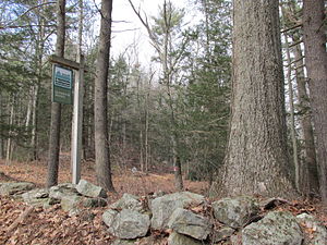
Quinebaug Woods
|
Quinebaug Woods
|
||
| location | Massachusetts , United States | |
| surface | 14.6 ha | |
| Geographical location | 42 ° 4 ' N , 72 ° 9' W | |
|
|
||
| Setup date | 2001 | |
| administration | The Trustees of Reservations | |
Quinebaug Woods ( German forest on long lake ) is a 36 acres (14.6 ha ) nature reserve in Holland in the state of Massachusetts in the United States . It is managed by The Trustees of Reservations organization.
Protected area
A 1.1 mi (1.8 km ) long circular route along the Quinebaug River leads through the reserve established around a drumlin on the basis of a property donation in 2001 . The forest consists mainly of oak , hickory , white ash , Weymouth pine and hemlock and provides animals such as forest frogs , American swamp frogs , toads , salamanders , beavers , kingfishers , Canada herons , sunfish , perch and in the area of Flora particular Cardinal lobelia one Habitat.
To the east is the Blake Hill , in the south of the Hamilton Reservoir to see. Directly adjacent is the Holland Pond Flood Control and Recreation Area (2.3 km²), and the Leadmine Wildlife Management Area (2.1 km²) is in the immediate vicinity .
The name "Quinebaug" comes from the language of the Indians living in southern New England , in which qunni means "long" and paug means "lake".
See also
Individual evidence
- ^ A b William Bright: Native American placenames of the United States . University of Oklahoma Press, Norman 2004, ISBN 978-0-8061-3576-2 ( online in Google Book Search).
- ↑ About Quinebaug Woods. The Trustees of Reservations , accessed May 7, 2014 .

