Råneälven
|
Råneälven Råne älv, Radnejokk, Rávnaädno, Raunajoki |
||
|
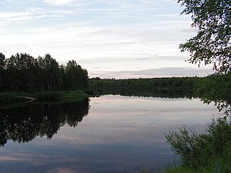
Råneälven near Mårdsel , Gällivare municipality |
||
| Data | ||
| location | Norrbottens län ( Sweden ) | |
| River system | Råneälven | |
| origin | Lake Radnejaure south of Gällivare 66 ° 54 ′ 14 ″ N , 20 ° 35 ′ 30 ″ E |
|
| muzzle | near Råneå in the Rånefjärden ( Gulf of Bothnia ) coordinates: 65 ° 49 ′ 42 ″ N , 22 ° 21 ′ 26 ″ E 65 ° 49 ′ 42 ″ N , 22 ° 21 ′ 26 ″ E |
|
| Mouth height |
0 m o.h.
|
|
| length | 210 km (including source rivers) | |
| Catchment area | 4,207.3 km² | |
| Drain |
MQ |
43 m³ / s |
| Flowing lakes | Degerselet | |
The Råneälven (also Råne älv , Radnejokk or Sami Rávnaädno , Finnish Raunajoki ) is a river in Norrbotten County in the far north of Sweden .
The 210 km long river has its origin in Lake Radnejaure (also Råne träsk or Råneträsket ) south of Gällivare . It flows mainly in a southerly direction and flows south of Råneå into the Rånefjärden bay of the Gulf of Bothnia in the Baltic Sea . The catchment area covers 4207.3 km².
The river was used for rafting until the 1950s . In the 1980s there were projects to build several hydropower plants on the river, but their implementation was initially ruled out in 1990 for nature conservation reasons (the Råneälven is one of the smaller Swedish rivers along with Byskeälven , Lögdeälven , Moälven , Öreälven and Vapstälven in the Vefsna catchment area the entire length of the expansion of hydropower is not permitted).
Individual evidence
- ↑ Sveriges Meteorologiska och Hydrologiska Institut (SMHI) - Län och huvudavrinningsområden i Sverige (PDF file; 2.41 MB)
- ↑ Sveriges skyddade älvar on vattenkraft.info (Swedish)
