Ría de Pontevedra
| Ría de Pontevedra | ||
|---|---|---|
|
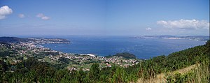
View of the Ría de Pontevedra from the southeast |
||
| Waters | Atlantic Ocean | |
| Land mass | Iberian Peninsula | |
| Geographical location | 42 ° 15 ′ N , 8 ° 45 ′ W | |
|
|
||
| width | approx. 10 km | |
| depth | approx. 25 km | |
| Tributaries | Lérez | |
The Ría de Pontevedra is a ria , i. H. a narrow, long and deeply incised bay, in the eponymous province of Pontevedra in Galicia in northeastern Spain . It belongs to the Rías Baixas and is located between the northern Ría de Arousa and the southern Ría de Vigo .
location
The Ría de Pontevedra stretches over a length of about 25 kilometers to the city of Pontevedra and is a maximum of about 10 kilometers wide. At the entrance to the bay is the Arquipélago de Ons with the Illa de Ons and other, also uninhabited, smaller rocky islands that are part of the Islas Atlánticas de Galicia National Park . At the end of the bay is the uninhabited Illa de Tambo ( Spanish Isla de Tambo ).
tourism
There are marinas on the estuary in Portonovo, Sanxenxo, Pontevedra, Combarro and Aguete. There are many beaches on the Ria de Pontevedra, the water temperatures in summer are around 14 ° C to 18 ° C.
Communities
Web links
- tourist information on the Ría de Pontevedra (German)
- Description on noonsite.com (English)
Individual evidence
- ↑ Diferencias de hasta cuatro grados en la ría en función de la playa. La Voz de Galicia, accessed June 26, 2016 .


