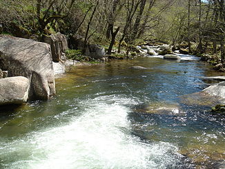
Río Francia
| Río Francia | ||
|
Río Francia at Las Casas del Conde |
||
| Data | ||
| location | Spain | |
| River system | Tagus | |
| Drain over | Alagón → Tagus → Atlantic | |
| source | Eastern flank of the Peña de Francia 40 ° 30 ′ 10 ″ N , 6 ° 8 ′ 49 ″ W |
|
| Source height | approx. 1200 msnm | |
| muzzle | at Sotoserrano in the Río Alagón Coordinates: 40 ° 25 ′ 50 " N , 6 ° 0 ′ 23" W 40 ° 25 ′ 50 " N , 6 ° 0 ′ 23" W |
|
| Mouth height | approx. 500 msnm | |
| Height difference | approx. 700 m | |
| Bottom slope | approx. 28 ‰ | |
| length | 25 km | |
| Communities | Miranda del Castañar | |
The Río Francia , with its length of only approx. 25 kilometers, is the eponymous river of the mountain region of the Sierra de Francia in the south of the province of Salamanca in the autonomous region of Castile-León .
course
The approximately 25-kilometer-long Río Francia rises - depending on rain or snowfall - at an altitude of around 1000 to 1300 meters on the Peña de Francia mountain . It initially flows in an easterly direction to swing south at Miranda del Castañar and flow into the Río Alagón in the area of the municipality of Sotoserrano ; on this short stretch, its gradient is around 700 to 1000 meters.
Tributaries
- Río Milano
Places on the river
history
In the Middle Ages and early modern times, there were several water mills on the banks of the Río Francia, of which, however, only sparse ruins can be guessed.
Attractions
Apart from the wooded mountain landscape along the river, the village of Miranda del Castañar , which is about 650 meters high, is extremely impressive; it was classified as a cultural asset ( Bien de Interés Cultural ) in the category Conjunto histórico-artístico as early as 1973 .
Web links
