Miranda del Castañar
| Miranda del Castañar municipality | ||
|---|---|---|
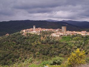
 Miranda del Castañar - town view
|
||
| coat of arms | Map of Spain | |

|
|
|
| Basic data | ||
| Autonomous Community : | Castile and Leon | |
| Province : | Salamanca | |
| Comarca : | Sierra de Francia | |
| Coordinates | 40 ° 29 ′ N , 6 ° 0 ′ W | |
| Height : | 649 msnm | |
| Area : | 21.07 km² | |
| Residents : | 402 (Jan. 1, 2019) | |
| Population density : | 19.08 inhabitants / km² | |
| Postal code : | 37760 | |
| Municipality number ( INE ): | 37193 | |
| administration | ||
| Website : | Miranda del Castañar | |
Miranda del Castañar is a place and a western Spanish municipality ( municipio ) with 402 inhabitants (at January 1, 2019) in the province of Salamanca in the autonomous community of Castile and Leon . The place was classified as a cultural asset ( Bien de Interés Cultural ) in the category Conjunto histórico-artístico as early as 1973 .
location
The mountain village of Miranda del Castañar is located about 500 m east of the Río Francia on a hilltop of the Sierra de Francia on the Río Quilamas at an altitude of about 650 m above sea level. d. M. The Río Alagón forms the southeastern border of the municipality. It is approx. 77 km (driving distance) in a north-easterly direction to Salamanca ; the lovely city of Ciudad Rodrigo is located about 67 km to the northwest. The places Valero and San Esteban de la Sierra , each about 14 km northeast, are also worth seeing. Because of the altitude, the climate is moderate; Rain (approx. 475 mm / year) falls mainly in the winter half-year.
Population development
| year | 1857 | 1900 | 1950 | 2000 | 2017 | 2018 |
| Residents | 1,559 | 1,667 | 1,892 | 654 | 416 | 399 |
The significant population decline since the 1950s is mainly due to the abandonment of small farms and the mechanization of agriculture and the associated loss of jobs.
economy
For centuries, the population lived as a self-sufficiency from agriculture (especially cattle breeding) and forestry (especially the production of charcoal); The craft ( wheelwright , blacksmith, etc.) and retail trade also played a certain role. In the area around the village there was and is still a small amount of viticulture. Since the 1960s, many vacant houses have been rented out as holiday homes (casas rurales) .
history
The emergence of the mountain village is related to the reconquest ( reconquista ) and subsequent recolonization ( repoblación ) of depopulated during the Muslim dominance areas in the north and center of the Iberian Peninsula by the Leonese king Alfonso VI. , Alfonso VII and Ferdinand II in the 11th and 12th centuries. The place belonged to the possession of the Order of St. John and was in the 13th century by Alfonso IX. made the administrative capital of the Sierra de Francia. In 1282 Pedro of Castile , son of Alfonso X and Infante , was landlord ( señor ) of several localities in the region. In 1457 Miranda del Castañar was raised to a county and given by King Henry IV of Castile and León (r. 1454–1474) to his loyal follower Diego López de Zúñiga ; In the 19th century it came to the House of Alba due to the marriage of the then Duke of Alba with the last Countess of Miranda.
Attractions
- The well-preserved castle of Miranda del Castañar, built in the 14th century, stands on the outskirts and is dominated by a keep ( torre de homenaje ); it is enclosed by a trapezoidal wall with round corner towers. In the 15th century it was taken over by the counts of the Zuñiga family and expanded.
- The almost square square in front of the castle, surrounded by houses made of quarry stone and / or half-timbered houses, is one of the oldest surviving bullring in Spain.
- The town wall ( muralla ) with four gates probably dates from the 13th century; however, it was repeatedly repaired. It is one of the few in Spain that has been almost completely preserved.
- The alleys of the place are also worth seeing.
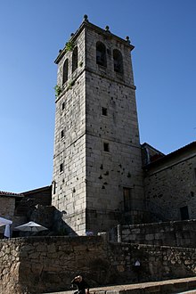
- The single-nave parish church of Santiago y San Ginés de Arlés dates from the 15th century; the interior is covered by an artesonado ceiling. The approximately 25 meter high bell tower ( campanar ) is made of large and precisely hewn granite blocks without mortar . Its only 'decor' is the slightly protruding window frames; the bells are not hung inside the tower, but in the eight arched openings .
Surroundings
- There are several hermit churches ( ermitas ) in the wooded area around the village .
- Wine was already grown in the region in earlier times. On hikes to San Esteban you will find the remains of former wine presses ( lagares ), which are carved into various granite rocks that cover the ground . Two basins are almost always arranged one behind the other, the lower one collecting the grape juice obtained.
See also
The Counts of Miranda also shaped the small town of Peñaranda de Duero in the province of Burgos with their buildings in the 16th century .
Web links
- Miranda del Castañar, sights - photos + information (Spanish)
- Miranda del Castañar, sights - video
- Surroundings of Miranda del Castañar, wine presses etc. - Photos + information (Spanish)
Individual evidence
- ↑ Cifras oficiales de población resultantes de la revisión del Padrón municipal a 1 de enero . Population statistics from the Instituto Nacional de Estadística (population update).
- ↑ Miranda del Castañar - Map with altitude information
- ↑ Miranda del Castañar - climate tables
- ↑ Miranda del Castañar - Population Development
- ↑ Miranda del Castañar - Sights
- ↑ Miranda del Castañar - Sights


