Vilvestre
| Vilvestre municipality | ||
|---|---|---|
 Vilvestre - Church and Town Hall ( ayuntamiento )
|
||
| coat of arms | Map of Spain | |

|
|
|
| Basic data | ||
| Autonomous Community : | Castile and Leon | |
| Province : | Salamanca | |
| Comarca : | La Ribera | |
| Coordinates | 41 ° 6 ′ N , 6 ° 43 ′ W | |
| Height : | 592 msnm | |
| Area : | 53.5 km² | |
| Residents : | 219 (Jan 1, 2019) | |
| Population density : | 4.09 inhabitants / km² | |
| Postal code : | 37258 | |
| Municipality number ( INE ): | 37311 | |
| administration | ||
| Website : | www.vilvestre.es | |
Vilvestre is a northwestern Spanish municipality ( municipio ) in the province of Salamanca in the autonomous community of Castile and Leon .
location
Vilvestre is located in the west of the province of Salamanca directly on the border with Portugal at an altitude of almost 600 meters above sea level. d. M. in the landscape of the Arribes del Duero Natural Park interspersed with granite rocks . The city of Salamanca is about 100 kilometers (driving distance) to the east; the historically significant and architecturally attractive city of Ciudad Rodrigo is about 75 kilometers south.
Population development
| year | 1950 | 1960 | 1970 | 1981 | 1991 | 2000 | 2018 |
| Residents | 1448 | 1394 | 906 | 695 | 711 | 629 | 232 |
In the 19th century the place had between 1700 and 1900 inhabitants; in the first half of the 20th century the number of inhabitants fell to around 1,400. As a result of job losses due to the mechanization of agriculture , the population has since fallen to its current low.
economy
Agriculture (agriculture and animal husbandry) traditionally plays the largest role in the municipality's economic life. Income from tourism in the form of renting out holiday homes ( casas rurales ) has increased over the last few decades.
history
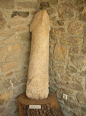
A Neolithic factory for stone tools has been found above the village . A phallic menhir was also discovered in the community area. After the largely bloodless recapture ( reconquista ) from the hands of the Moors and the repopulation ( repoblación ) of the almost deserted mountain region in the 11th and 12th centuries, the region near the border initially belonged to the dominion of the Leonese and Castilian kings; However, they handed the latter over to individual landlords ( señores ) around 1340 , who from then on took over border security until Isabella I handed the region over to the Dukes of Alba in the late 15th century .
Attractions
- The aforementioned phallically shaped 'menhir' is on display in the local museum today.
- The parish church ( Iglesia de Nuestra Señora de la Asunción ) dates from the 16th century, as the transition phase from the late Gothic to the Renaissance . Inside there are several carved and painted altarpieces from the 18th century.
- A richly decorated baroque court pillar ( roller blind ) with a cross at the top stands on a stepped base in the town's main square.
- A hermit church ( Ermita de la Virgen del Castillo ) stands near the ruins of an old castle ( castillo ) at the foot of the mountain that towers above the place ( 41 ° 6 ′ 16 ″ N , 6 ° 43 ′ 49 ″ W ). Inside there is a granite altarpiece .
- There are several interesting viewpoints in the vicinity of the place - one of them with a stone cross.
Web links
Individual evidence
- ↑ Cifras oficiales de población resultantes de la revisión del Padrón municipal a 1 de enero . Population statistics from the Instituto Nacional de Estadística (population update).


