Gomecello
| Gomecello municipality | ||
|---|---|---|
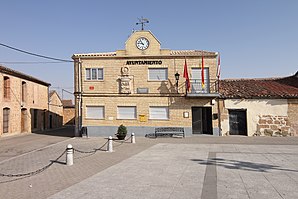
 town hall
|
||
| coat of arms | Map of Spain | |
 Help on coat of arms |
|
|
| Basic data | ||
| Autonomous Community : | Castile and Leon | |
| Province : | Salamanca | |
| Comarca : | La Armuña | |
| Coordinates | 41 ° 3 ′ N , 5 ° 32 ′ W | |
| Height : | 840 msnm | |
| Area : | 20.70 km² | |
| Residents : | 442 (Jan. 1, 2019) | |
| Population density : | 21.35 inhabitants / km² | |
| Postal code : | 37420 | |
| Municipality number ( INE ): | 37152 | |
| administration | ||
| Mayor : | Rosa Mª Esteban ( PP ) | |
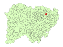
| Location of the municipality | ||

|
||
Gomecello is a small western Spanish municipality ( municipio ) in the province of Salamanca in the autonomous community of Castile and Leon . It is located about 13 kilometers northeast of the provincial capital Salamanca . In 2019 it had 442 inhabitants.
geography
The area of the municipality is 20.70 km² and, in addition to the main town, only includes very sparsely developed farmland and a large recycling center.
The municipality is crossed by the parallel roads N-620 and A-62 , to which Gomecello also has connections. In addition, a railway line runs through the place.
Population development
The population of the village increased until 1950, but Gomecello, like most municipalities in the region, experienced a sharp decline in population in the second half of the 20th century. In 2019 only 442 people lived there.
| year | 1900 | 1920 | 1940 | 1960 | 1981 | 1991 | 2001 | 2017 | 2018 |
| Residents | 348 | 538 | 905 | 1013 | 693 | 635 | 520 | 455 | 444 |
Buildings
- Iglesia de Nuestra Señora de la Merced, medieval church
Web links
Individual evidence
- ↑ Cifras oficiales de población resultantes de la revisión del Padrón municipal a 1 de enero . Population statistics from the Instituto Nacional de Estadística (population update).

