Monleón (Salamanca)
| Monleón municipality | ||
|---|---|---|
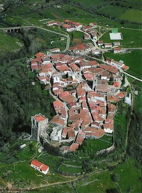
 Monleón - the townscape
|
||
| coat of arms | Map of Spain | |

|
|
|
| Basic data | ||
| Autonomous Community : | Castile and Leon | |
| Province : | Salamanca | |
| Comarca : | Entresierras | |
| Coordinates | 40 ° 35 ′ N , 5 ° 51 ′ W | |
| Height : | 878 msnm | |
| Area : | 19.10 km² | |
| Residents : | 93 (Jan. 1, 2019) | |
| Population density : | 4.87 inhabitants / km² | |
| Postal code : | 37765 | |
| Municipality number ( INE ): | 37197 | |
Monleón is a place and a central Spanish municipality ( municipio ) with 93 inhabitants (at January 1, 2019) in the province of Salamanca in the autonomous community of Castile and Leon .
location
The place Monleón is located on a hill about 875 meters high on the upper reaches of the Río Alagón . It is approx. 60 kilometers (driving distance) in a northerly direction to Salamanca ; the beautiful city of Ciudad Rodrigo is located about 80 kilometers to the west.
Population development
| year | 1960 | 1970 | 1981 | 1991 | 2000 | 2014 |
| Residents | 389 | 246 | 194 | 124 | 135 | 92 |
In the 19th century, the place often had well over 500 inhabitants; As a result of the mechanization of agriculture, there has been a constant population decline in the 20th century.
economy
For centuries, the population lived on agriculture (especially cattle breeding) as a self-sufficient living ; Vegetables for personal use are still grown in the terraced gardens on the hillside. The craft ( wheelwright , blacksmith, etc.) and retail trade also played a certain role. Many vacant houses have been rented out as holiday homes since the 1960s.
history
Although the hill was easy to defend, there are no written or archaeological finds from prehistoric, Celtic, Roman, Visigothic and Moorish times; only the body of an 'Iberian bull' ( verraco ) and a few stone sarcophagi indicate a (temporary) settlement of the square. The first mention of the place name ( Leocaput ) comes from the year 939; in the year 1077 the reconquest of the area ( reconquista ) by Alfonso VI falls . from the hands of the Moors - afterwards the place was developed into a border fortress. Alfonso IX granted him city rights in 1199; As a result, the town and castle were surrounded by a wall ring, which - repeatedly restored - is still largely preserved.
Attractions
- At the walled entrance to the town, an 'Iberian bull' ( verraco ) found in the area was set up, which may originally have served as a symbol of fertility and / or sovereignty , but was set up outside the town in the Middle Ages to protect the herds of cattle.
- The 37 meter high keep ( torre de homenaje ) of the 15th century castle ( castillo ) is one of the highest and best preserved in Spain. At the top there is a platform enclosed by parapet walls with eight semicircular weir cores, which contribute greatly to the majestic impression of the late medieval building. Other parts of the castle walls, which were once crowned with battlements, have also been preserved. The castle is privately owned and can only be viewed from the outside.
- The local parish church, built in the 16th century, stands on the opposite side of the castle hill. Some columns and stones from a previous Romanesque building were reused as spolia .
- A few anthropomorphic sarcophagi have been discovered at the foot of the castle hill, some of which date to the 6th or 7th century; but later dates are also possible.
Web links
- Monleón, history and monuments - photos + info (Spanish)
- Monleón, sights - photos + information (Spanish)
- Monleón, sightseeing photos
- Monleón, Castle - Photos + Info (Spanish)
Individual evidence
- ↑ Cifras oficiales de población resultantes de la revisión del Padrón municipal a 1 de enero . Population statistics from the Instituto Nacional de Estadística (population update).
