
Cabeza del Caballo
| Cabeza del Caballo municipality | |||
|---|---|---|---|
 Cabeza del Caballo - village square
|
|||
| coat of arms | Map of Spain | ||

|
|
||
| Basic data | |||
| Autonomous Community : |
|
||
| Province : | Salamanca | ||
| Comarca : | La Ramajería | ||
| Coordinates | 41 ° 8 ′ N , 6 ° 34 ′ W | ||
| Height : | 732 msnm | ||
| Area : | 44.98 km² | ||
| Residents : | 279 (Jan 1, 2019) | ||
| Population density : | 6.2 inhabitants / km² | ||
| Postal code : | 37214 | ||
| Municipality number ( INE ): | 37065 | ||

Cabeza del Caballo denotes a northwestern Spanish town and a municipality ( municipio ) with 279 inhabitants (at January 1, 2019) in the province of Salamanca in the autonomous community of Castile and Leon . The hamlet (pedanía) Fuentes de Masueco also belongs to the municipality .
Location and climate
The place Cabeza del Caballo is located in the northwest of the province of Salamanca at an altitude of approx. 730 m in the rocky landscape of the Arribes del Duero Natural Park . The Río Uces flows past the place about 2 km away; in places it forms the border to the neighboring communities Mieza and Vitigudino and further to Ledesma . The provincial capital Salamanca is about 90 km (driving distance) to the east. The climate is temperate to warm; Rain (approx. 675 mm / year) falls mainly in the winter half-year.
Population development
| year | 1857 | 1900 | 1950 | 2000 | 2017 | 2018 |
| Residents | 834 | 931 | 1,055 | 482 | 316 | 291 |
In the first half of the 20th century, the community always had between 780 and 950 inhabitants. As a result of job losses due to the mechanization of agriculture , the population has since declined to current lows.
economy
Agriculture (agriculture and animal husbandry) traditionally plays the largest role in the municipality's economic life. Income from tourism in the form of renting out holiday homes (casas rurales) has increased over the last few decades.
Attractions
- The small one in the 15th / 16th Iglesia Santa María Magdalena , built in the 16th century, has a richly designed two-storey bell gable (espadaña) with three arched openings in the west and a column-supported porch (portico) with an entrance portal on the south side. Inside there is a monolithic holy water font .
- On the outskirts is a stone -mouth status (potro de herrar) for fixing and fogging of ungulates (working horses, oxen, donkeys). Hoof care measures were also carried out here.
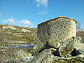
- A round pigsty (pocilga) built from small field stones is a testimony of rural rural life that is rarely preserved today. Its forecourt, which is also round, is framed by large stone blocks.
- Surroundings
- An arch bridge (Puente Robleo) built from roughly hewn granite stones over the Río Uces, which flows past the site in about 2 km, dates from the 17th or 18th century. It connects the place with the neighboring communities. The bridge consists of a large central arch and two smaller lateral arches.
- Also about 2 km outside the village is an old water mill (Molino de Lucas) made of stone masonry . The masonry and grinder were completely restored around the turn of the millennium; demonstrations take place on some days.
- The Molino de David is another watermill on the Río Uces.
- An approximately 20 m long stone slab footbridge made of approximately 2.50 m long granite slabs on twelve roughly assembled pillars also crosses the river.
- At the edge of the field there is a stone hut (chozo) made of dry stone .
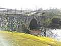
Arch Bridge ( Puente Robleo )
Watermill ( Molino de Lucas )

Stone slab footbridge over the Río Uces

Wooden bridge ( puente palo )


Web links
Individual evidence
- ↑ Cifras oficiales de población resultantes de la revisión del Padrón municipal a 1 de enero . Population statistics from the Instituto Nacional de Estadística (population update).
- ↑ Cabeza de Caballo - climate tables