Calzada de Valdunciel
| Calzada de Valdunciel parish | ||
|---|---|---|
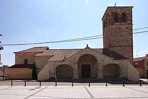
 Calzada de Valdunciel - Iglesia de Santa Elena
|
||
| coat of arms | Map of Spain | |

|
|
|
| Basic data | ||
| Autonomous Community : | Castile and Leon | |
| Province : | Salamanca | |
| Comarca : | La Armuña | |
| Coordinates | 41 ° 5 ′ N , 5 ° 42 ′ W | |
| Height : | 800 msnm | |
| Area : | 20.03 km² | |
| Residents : | 703 (Jan. 1, 2019) | |
| Population density : | 35.1 inhabitants / km² | |
| Postal code : | 37797 | |
| Municipality number ( INE ): | 37073 | |
| administration | ||
| Website : | Calzada de Valdunciel | |
Calzada de Valdunciel is a place and a western Spanish municipality ( municipio ) with 703 inhabitants (at January 1, 2019) in the province of Salamanca in the autonomous community of Castile and Leon . The place was located on the ancient trade route Via de la Plata , which now forms a branch of the Camino de Santiago that comes from the south ( Seville , Mérida , Cáceres , Salamanca ) and joins the main route at León or Astorga .
Location and climate
The place Calzada de Valdunciel is located in the Castilian plateau (meseta) approx. 14 km (driving distance) north of the provincial capital Salamanca at an altitude of approx. 800 m . The climate is temperate to warm; Rain (approx. 395 mm / year) falls mainly in the winter half-year.
Population development
| year | 1857 | 1900 | 1950 | 2000 | 2017 |
| Residents | 885 | 921 | 1,016 | 659 | 666 |
The significant population decline since the 1950s is mainly due to the mechanization of agriculture and the abandonment of small farms and the associated loss of jobs.
economy
The fertile but dry soils in the area provided the basis for the cultivation of wheat and other crops for the inhabitants, who in earlier times lived mainly as self-sufficient . Traders, craftsmen and service providers of all kinds gradually settled in the town itself.
history
Celtic and Visigoth finds have not yet been made; However, several Roman milestones (miliaria) and a grave monument were discovered in the municipality . The region was overrun by the Arabs and their Moorish auxiliaries in the 8th century ; However, there is no archaeological evidence. The area around Calzada was at the end of the 11th century by the Castilian - Leonese troops of Alfonso VI. (ruled 1065–1109) recaptured from the hands of the Moors ( reconquista ) and successively repopulated by Christians from the north and by refugees from Al-Andalus ( repoblación ) .

Attractions
- The Fuente Buena is the remains of an ancient funerary monument; a reclining female figure can still be seen.
- The broken remains of several Roman milestones found in the municipality are exhibited in a square at the exit of the village, which were misappropriated in the Middle Ages and used as bridge piers .
- The Iglesia de Santa Elena was built in the 16th century on the site of a previous medieval building, of which small remains have been preserved. The triumphal arched vestibule of the entrance portal was added in the 18th century. Nave (nature) and vestibule are covered wood; the late Baroque altarpiece (retablo) in the style of Churriguerism also dates from the 18th century.
Web links
Individual evidence
- ↑ Cifras oficiales de población resultantes de la revisión del Padrón municipal a 1 de enero . Population statistics from the Instituto Nacional de Estadística (population update).
- ↑ Calzada de Valdunciel - Climate tables
- ↑ Calzada de Valdunciel - population development
- ↑ Calzada de Valdunciel - Church
