
Arribes del Duero Natural Park
| Arribes del Duero Natural Park | |||
|---|---|---|---|
.jpg) |
|||
|
|||
| Location: | Castile and León , Spain | ||
| Next city: | Zamora ; Salamanca | ||
| Surface: | 106,105 ha | ||
| Founding: | April 11, 2002 | ||
 |
|||

The Arribes del Duero Natural Park ( Spanish : Parque Natural de Arribes del Duero ) is a 11 April 2002 by the Junta de Castilla y León to life Called protected landscape area in the west of the Spanish provinces of Salamanca and Zamora in the autonomous region of Castilla-Leon at the border with Portugal .
geography
Position and extent
The partly inhabited, partly agriculturally used and partly untouched protected area extends about 80 kilometers in north-south direction on the border with Portugal formed by the rivers Duero and Águeda . It is on average only about 15 to 20 kilometers wide and covers an area of about 1060 square kilometers. On the Portuguese side there is a similarly dimensioned nature park ( Parque natural do Douro Internacional ).
geology
The subsoil is formed by very old granite rock of volcanic origin, which appears in several places on the surface and sometimes forms spectacular rock formations. Other rocks in the region are gneiss and slate .
landscape
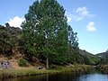
The landscape is characterized by ravines formed by rivers that have carved themselves into a plateau interspersed with granite rocks over the course of several million years. The slopes of the steeply sloping gorges are forested, while agriculture and grazing are practiced on the plateaus.

Rivers and reservoirs
.jpg)
The area of the nature park is traversed by several rivers - the largest are the Río Duero, Río Tormes and Río Águeda . Five reservoirs ( presas ) of the Duero reservoirs ( Saltos de Duero ) with connected hydropower plants with an annual output of about 5000 GWh are wholly or partially located in the area of the nature park: Aldeadávila , Almendra , Castro , Saucelle and Villalcampo ; they are fed by the Duero and Tormes rivers - the latter flows into the Duero in the west of the nature park near the Portuguese town of Barca d'Alva . In addition, there are three dams that are Portuguese responsibility.
traffic
The nature park can be reached from the cities of Salamanca or Zamora via various roads, the further course of which often leads to Portugal. There are smaller road connections in north-south direction between the places in the park.
climate
The comparatively rainy area of the nature park, which is mostly located at altitudes between 600 and 800 meters, has a more moderate climate with maximum summer temperatures that rarely reach values above 30 ° C; in the nights it cools down significantly - depending on the cloudiness. In winter, the daily maximum temperatures reach 10 to 15 ° C; at night the thermometer often falls below the frost line. Almost every year snow falls on a few days, but it rarely remains for long periods of time. In the deeply cut river valleys there is a rather subtropical - Mediterranean microclimate .

Duero at Aldeadávila

Landscape near Badilla

Waterfall at Pereña de la Ribera
River landscape near Castro de Alcañices

"Thick rock" near La Peña

Winter landscape near Hinojosa de Duero


population
.jpg)

Population development
| year | 2000 | 2002 | 2004 | 2006 | 2008 | 2010 |
| Residents | 19,718 | 18,957 | 18,229 | 17,529 | 17,010 | 16,514 |
The steadily falling population is primarily related to the loss of jobs as a result of the increasing mechanization of agriculture .
Communities
Province of Salamanca Ahigal de los Aceiteros , Aldeadávila de la Ribera , Almendra , Barruecopardo , Bermellar , La Bouza , Cabeza del Caballo , Cerezal de Peñahorcada , La Fregeneda , Hinojosa de Duero , Lumbrales , Masueco , Mieza , La Peña , Pereña de , Puerto Seguro , Saldeana , San Felices de los Gallegos , Saucelle , Sobradillo , Trabanca , Villarino de los Aires , Vilvestre and La Zarza de Pumareda Province of Zamora Argañín , Fariza , Fermoselle , Fonfría , Gamones , Moral de Sayago , Moralina , Pino del Oro , Torregamones , Villadepera , Villalcampo , Villar del Buey and Villardiegua de la Ribera villages and hamlets Badilla , Carbajosa , Castro de Alcañices , Corporario , Cozcurrita , Fuentes de Masueco , Fornillos de Fermoselle , Formariz , Mámoles , Palazuelo de Sayago , Pinilla de Fermoselle , Salto de Aldeadávila , Salto de Castro , Salto de Saucelle , Salto de Villalcampo , Tudera and Zafara
economy
The region has always been oriented towards agriculture, with both field cultivation and pasture farming. There are also isolated vineyards and olive and fruit tree plantations, mainly in the south . In the last few decades there has been income from tourism , but due to the location away from all main roads, the number of visitors to the nature park is limited: in 2010 it was almost 40,000.
history
Before the Romans the area was inhabited by the Celtic people of the Vettons ; the Romans incorporated the area south of the Duero into the province of Lusitania , while the north of the province of Tarraconensis was added. Later the region belonged to the Visigoth Empire , then to the Islamic Al-Andalus . The recapture ( reconquista ) of the almost deserted area was largely bloodless. After its resettlement - or better - repopulation ( repoblación ) in the 11th and 12th centuries, the area south of the Duero was for a long time disputed between the Kingdom of Portugal and the Kingdom of León (later the Kingdom of Castile ): in 1295 the Portuguese King Dinis ; two years later, the border between the two kingdoms was established in the Treaty of Alcañices . The Castilian kings handed the area over to individual landlords ( señores ) around 1340 , who from then on took over the border security until the Catholic kings Ferdinand and Isabella transferred it to the dukes of Alba in the 15th century .
Attractions
Even if the landscape and nature are in the foreground of the visitor interest, there are also some culturally and historically significant artefacts such as (Celtic) Iberian animal figures ( verracos ), Roman or Gallo-Roman grave steles as well as medieval castles, churches and bridges.

Iberian bull from Villardiegua de la Ribera

Stele with Latin characters in Hinojosa de Duero
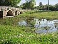
'Roman Bridge' near Tudera

Defense tower of Sobradillo

Fermoselle Church

Church of Aldeadávila de la Ribera

Church of Villadepera

Baroque bell gable of Fariza Church


.jpg)
.jpg)
.jpg)


Ecosystem
The sparsely populated nature park with its diverse landscape offers diverse retreats and breeding areas for rare animal and bird species. The area has been designated as a European bird sanctuary since 1990 .
fauna
Birds
The breeding birds include the white stork and its seldom - breeding in forests - relative, the black stork, as well as various species of birds such as griffon and Egyptian vulture , golden eagle and eagle , red kite , peregrine falcon and eagle owl . There are also various species of crows , rock swallows and red swallow , blue swallows , alpine swallows , etc.


Mammals
Among the mammals, 14 species of bats are to be highlighted, as well as the wild cats and gorse cats , which are threatened with extinction . Fish otters, which have become rare, live near the rivers and reservoirs . Even wild boars , the European badger and various Marder - and dormouse species , rabbits etc. can reasonably intact habitats.

.JPG)


Fish and reptiles
The many different types of fish are mostly due to human influence (creation of reservoirs). Other native fish or migratory fish species such as the European sturgeon , salmon and eel , on the other hand, have almost become extinct. Among the water-loving amphibians are toads , frogs and newts ; Lizards , snakes and tortoises live in the rocky rocks .


flora
The native wild trees include juniper and cork oak , which mostly thrive in the closed forest areas along the deeply cut rivers. The flatter areas in the south of the nature park, however, are covered by vine , olive and fruit trees.

Vine field near Aldeadávila de la Ribera

Olive trees near Mieza


Web links
- Park website - photos, videos + info (Spanish)
- Park website - photos + info (Spanish)