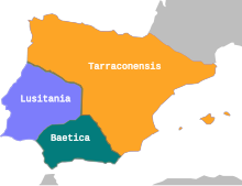
Tarraconensis

Hispania Tarraconensis , later mostly simply Tarraconensis , was a Roman province in what is now Spain and Portugal . It included the north and east of Spain and northern Portugal to the Douro . Southern Spain, today's Andalusia , was the province of Hispania Baetica . Central and southern Portugal with the east bordering Spanish regions including Mérida , Talavera de la Reina and Salamanca , but without Toledo , formed the province of Lusitania .
At the time of the Roman Republic, the areas of the Iberian Peninsula ruled by it were divided into two provinces, the
- Hispania citerior (north and east) and the
- Hispania ulterior (south and west).
On the Mediterranean coast, the border was southwest of Carthago Nova (today Cartagena ) and ran from there in a west-northwest direction. Due to the provincial reform under Emperor Augustus , the Hispania ulterior was divided into two parts shortly before the new era, Hispania Baetica and Lusitania , while Hispania citerior initially remained unchanged. Like Lusitania, it became an imperial province , while Baetica belonged to the senatorial provinces . In a later step, Emperor Augustus moved the border, whereby the Hispania citerior was enlarged somewhat at the expense of the Baetica ; since then the border was on the coast near the present-day city of Almería and ran from there in a north-west direction. Since the seat of the governor of Hispania citerior was the city of Tarraco , today's Tarragona in Catalonia , people soon began to call this province Hispania Tarraconensis . The official name in the title of the governor was still Hispania citerior . The governor was an imperial legate of consular rank.
The province was divided into seven judicial districts:
- Tarraco,
- Carthago Nova ( Cartagena ),
- Caesaraugusta ( Saragossa ),
- Clunia (Coruña del Conde),
- Lucus Augusti ( Lugo ),
- Asturica Augusta ( Astorga ) and
- Bracara Augusta ( Braga ).
60–68 the future Emperor Galba was governor of the Tarraconensis ; he rebelled against Emperor Nero in 68 and then became his successor. Emperor Caracalla (211-217) separated from the Hispania citerior or Tarraconensis a new province, the Hispania nova citerior Antoniniana , which was located in the northwest of the peninsula north of the Duero . Its existence can only be deduced from inscriptions and its extent is not exactly known, because it was reunited with the Tarraconensis by the thirties of the 3rd century at the latest .
In the period 283-289, Emperor Diocletian increased the number of provinces in his regional reform. The former area of Hispania citerior was divided into three provinces in late antiquity , the Gallaecia (Galicia), the Carthaginiensis with the capital Carthago Nova and the Tarraconensis with the capital Tarraco (Tarragona). This new Tarraconensis only comprised the northeast of the former Hispania citerior . It is unclear whether it reached in the west as far as Villaviciosa and the upper reaches of the Esla or whether Cantabria belonged to Gallaecia . The border with the Carthaginiensis ran north of Segobriga , Segontia (Sigüenza), Uxama ( Osma ) and Clunia (Coruña del Conde).
In the 5th century , the Tarraconensis was repeatedly affected by barbarian incursions and Bagauden uprisings , with the Visigoths finally asserting themselves as new masters, who, however, submitted to Roman suzerainty for a long time. The last emperor to enter the province at the head of an army was a Majorian in 461 ; the last emperor to be recognized at least in writing in the Tarraconensis was Anthemius around 470 . Then the (West) Goths took what was later known as Gotholunia , Gathalánia and Catalonia ( Catalonia ).
literature
- Tilmann Bechert : The provinces of the Roman Empire. Introduction and overview. (= Ancient World . Special Issues; = Orbis Provinciarum ; = Zabern's illustrated books on archeology ). Philipp von Zabern, Mainz 1999, ISBN 3-8053-2399-9 , pp. 65-71.
- Franz Braun: The development of the Spanish provincial borders in Roman times (= sources and research on ancient history and geography. Volume 17). Weidmann, Berlin 1909.
- Rudolf Haensch : Capita provinciarum. Governor's seat and provincial administration in the Roman Empire ( Cologne Research. Volume 7). Philipp von Zabern, Mainz 1997, ISBN 3-8053-1803-0 .
- Julia Hoffmann-Salz: The economic effects of the Roman conquest. Comparative studies of the provinces Hispania Tarraconensis, Africa Proconsularis and Syria (= Historia individual writings. Volume 218). Steiner, Stuttgart 2011, ISBN 978-3-515-09847-2 , pp. 29-153. ( Review by H-Soz-Kult ).
- Patrick Le Roux: L'armée romaine et l'organization des provinces ibériques d'Auguste à l'invasion de 409. (= Publications du Center Pierre Paris. Volume 8; = Collection de la Maison des Pays Ibériques. Volume 9). Boccard, Paris 1982, ISBN 2-7018-0002-1 .
- Daniel Nony: The Spanish provinces. In: Claude Lepelley (ed.): Rome and the empire in the high imperial era. Volume 2: The regions of the empire. Saur, Munich et al. 2001, ISBN 3-598-77449-4 , pp. 121-150. (Overview with good bibliography)
- Walter Trillmich , Annette Nünnerich-Asmus (Hrsg.): Monuments of the Roman era ( Hispania Antiqua ). Philipp von Zabern, Mainz 1993, ISBN 3-8053-1547-3 .
annotation
- ↑ Angel Montenegro Duque, José María Blázquez Martínez: Historia de España. ed. Ramón Menéndez Pidal / José María Jover Zamora, Volume 2: España romana. Madrid 1982, pp. 260f .; Claudio Sánchez-Albornoz: Divisiones tribales y administrativas del solar del reino de Asturias en la época romana. In: ders., Orígenes de la nación española. Volume 1, Oviedo 1972, pp. 99f. (and map).
- ^ Johann Jakob Egli : Nomina geographica. Language and factual explanation of 42,000 geographical names of all regions of the world. 2nd Edition. Friedrich Brandstetter, Leipzig 1893, p. 176 ( Cataluña ).
Web links
- The Roman conquest of the province of Tarraconensis ( Memento of June 11, 2009 in the Internet Archive )
Coordinates: 41 ° N , 1 ° E

