Fermoselle
| Fermoselle municipality | ||
|---|---|---|
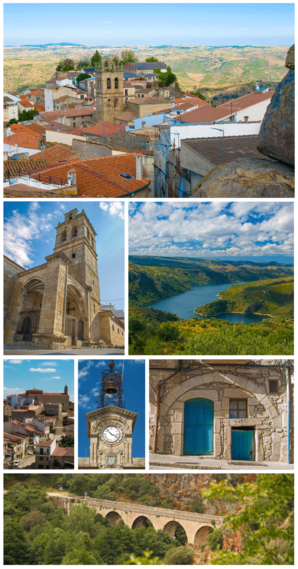
 Fermoselle - photo collage
|
||
| coat of arms | Map of Spain | |

|
|
|
| Basic data | ||
| Autonomous Community : | Castile and Leon | |
| Province : | Zamora | |
| Comarca : | Sayago | |
| Coordinates | 41 ° 19 ′ N , 6 ° 24 ′ W | |
| Height : | 650 msnm | |
| Area : | 68.13 km² | |
| Residents : | 1,206 (Jan 1, 2019) | |
| Population density : | 17.7 inhabitants / km² | |
| Postal code : | 49220 | |
| Municipality number ( INE ): | 49065 | |
| administration | ||
| Website : | Fermoselle | |
Fermoselle is a municipality ( municipio ) in northern Spain in the province of Zamora in the autonomous community of Castile and León . The place has been recognized as a cultural asset ( Bien de Interés Cultural ) in the Conjunto histórico-artístico category since 1974 .
Location and climate
Fermoselle is located on an approx. 650 m high ridge in the extreme southwest of the province of Zamora in the rocky landscape of the Arribes del Duero nature park near the border with Portugal formed by the Duero river . The village of Tudera is about 25 km northeast; the provincial capital Zamora is about 60 km (driving distance) to the northeast. The Portuguese municipality of Bemposta is only 15 km to the west. The climate is temperate to warm; Rain (approx. 575 mm / year) falls mainly in the winter half-year.
Population development
| year | 1857 | 1900 | 1950 | 2000 | 2017 |
| Residents | 4,376 | 4,624 | 4,364 | 1,646 | 1,262 |
The mechanization of agriculture and the abandonment of small farms led to a significant population decline since the second half of the 20th century.
economy
Agriculture, especially the planting of grapevines and olive and fruit trees, traditionally plays the largest role in the economic life of the small town. An iron ore mine is also mentioned in the area in the 16th century . In addition, the place functioned as a trade, craft and service center for the villages and hamlets in the region as early as the Middle Ages. Income from tourism in the form of renting out holiday homes (casas rurales) has increased over the last few decades.
history
Finds of stone axes in the area indicate a long settlement that was also continued by the Celts and Romans - some researchers believe that they can localize the place Ocellum Durii , Ocella or Ocila mentioned in Roman sources here . There are no traces of any traces from the Visigothic and Moorish times . After the reconquest ( reconquista ) of the north of the Iberian Peninsula from the hands of the Moors , the Leonese King Alfonso IX handed over the castle . in 1205 the area including the place became the manorial rule (señorio) of the bishop of Zamora . In 1221, however, he granted the place extensive independence by means of a letter of privilege ( fuero ) because of its strategically important border location with the Kingdom of Portugal .
Attractions
- Although there are no significant sights, the often winding streets of the old town invite you to stroll; Side streets often end in a lookout point (mirador) . The whole place is recognized as a conjunto histórico-artístico .
- The Castillo de Doña Urraca , which was largely destroyed during the Comuneros uprising, is located on the highest point of the ridge with a view over the surrounding land and the valley of the Duero River. The keep (torre de homenaje) and parts of the outbuildings are still preserved .
- The parish church of the village (Iglesia de Nuestra Señora de la Asunción) , built in the early 13th century, has late Romanesque - early Gothic origins, which are particularly visible in the two slightly pointed archivolt portals on the west and south sides - both portals are abstract -vegetable motifs. The rest of the church has been rebuilt and supplemented repeatedly - the bell tower (campanario) on the south side with an adjacent atrium is from the Renaissance . The interior of the church has a single nave and ends in a flat end of the choir with a carved and colored altarpiece (retablo) .
- The facade of the town hall (ayuntamiento) is crowned by a finely chiselled wrought-iron bell attachment.
- There are numerous rock cellars ( bodegas ) in the outskirts of the village .
- Surroundings
- A little outside the village is a Franciscan monastery from the 18th century, which is now used as an information center for the Arribes del Duero Natural Park .
Personalities
- Juan del Encina (1468–1529), Renaissance poet and composer, was born in Fermoselle.
Web links
Individual evidence
- ↑ Cifras oficiales de población resultantes de la revisión del Padrón municipal a 1 de enero . Population statistics from the Instituto Nacional de Estadística (population update).
- ↑ Fermoselle - climate tables
- ↑ Fermoselle - population development
- ↑ Fermoselle - History
- ↑ Fermoselle - Church

