Santovenia
| Santovenia municipality | ||
|---|---|---|
 Santovenia - town view
|
||
| coat of arms | Map of Spain | |

|
|
|
| Basic data | ||
| Autonomous Community : |
|
|
| Province : | Zamora | |
| Comarca : | Benavente y Los Valles | |
| Coordinates | 41 ° 53 ' N , 5 ° 43' W | |
| Height : | 715 msnm | |
| Area : | 32.86 km² | |
| Residents : | 241 (Jan. 1, 2019) | |
| Population density : | 7.33 inhabitants / km² | |
| Postal code : | 49750 | |
| Municipality number ( INE ): | 49207 | |
| administration | ||
| Website : | Santovenia | |
Santovenia is a town in northern Spain and the capital of a municipality (municipio) with 241 inhabitants (as of January 1, 2019 ) in the province of Zamora in the autonomous Spanish region of Castile-León . The place is on a branch of the Camino de Santiago that comes from the south ( Seville , Mérida , Cáceres , Salamanca and Zamora ) and joins the main route in León or Astorga .
Location and climate
The place Santovenia is located in the Iberian plateau (meseta) about 46 km (driving distance) north of the provincial capital Zamora at about 715 m altitude on a hill about 2 km east of the river Esla . The winter temperatures are quite cool, whereas in summer it is warm to hot; the sparse rainfall (approx. 420 mm / year) falls throughout the year with the exception of the summer months.
Population development
| year | 1857 | 1900 | 1950 | 2000 | 2017 |
| Residents | 555 | 791 | 1,157 | 431 | 273 |
The significant population decline since the 1950s is essentially due to the mechanization of agriculture and the abandonment of small farms and the resulting lack of jobs in rural areas ( rural exodus ).
economy
The Agriculture formed the basis of life for as has always been self surviving population of the region; Craftsmen, small traders and service providers of all kinds settled in the village.
history
Although the place was on Via de la Plata , which was already in use in antiquity , Celtic, Roman, Visigoth and even Moorish traces have not yet been found. The earliest mention of the place name Santa Ovenia comes from a document from 1167. Later it was in the possession of the dukes and counts of Benavente .
Sights and culture
- The Iglesia de Nuestra Señora del Tobar , built largely from rubble stones , seems to date from the 16th / 17th centuries. Century to date; the eastern parts were in 17./18. Century renewed in Mudejar style . The bell gable (espadaña) made of precisely hewn stones also seems to be of more recent date.
- Surroundings
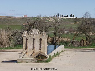
- At the foot of the village there is a spring with an attached well and cattle trough .
Web links
Individual evidence
- ↑ Cifras oficiales de población resultantes de la revisión del Padrón municipal a 1 de enero . Population statistics from the Instituto Nacional de Estadística (population update).
- ↑ Santovenia - climate tables
- ↑ Santovenia - Population Development

