Río Isuela (Huesca)
| Río Isuela (Huesca) | ||
|
The basin of the Cinca |
||
| Data | ||
| location | Huesca Province , Spain | |
| River system | Ebro | |
| Drain over | Flumen → Alcanadre (river) → Cinca → Segre → Ebro → Mediterranean | |
| source | Sierra de Bonés | |
| Source height | 1106 m msnm | |
| muzzle | near Buñales in the Río Flumen coordinates: 42 ° 2 ′ 0 ″ N , 0 ° 25 ′ 0 ″ W 42 ° 2 ′ 0 ″ N , 0 ° 25 ′ 0 ″ W |
|
| Mouth height | 310 m msnm | |
| Height difference | 796 m | |
| Bottom slope | 20 ‰ | |
| length | 40 km | |
| Medium-sized cities | Huesca | |
|
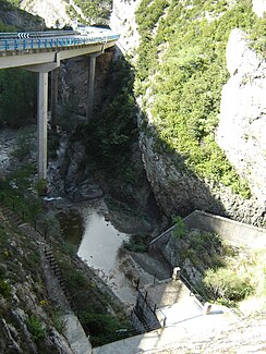
Outflow of the Isuela at the Presa de Arguis |
||
The Río Isuela (Huesca) - to be distinguished from the Río Isuela (Saragossa) , which drains via Aranda and Jalón to the Ebro - is a river in the Spanish province of Huesca . It rises at 1106 m above sea level on the southeast slope of the Collado de Labarzain in the Aragonese Pyrenees , is dammed by the Presa de Arguis, flows through the Foz de San Clemente gorge and subsequently the city of Huesca and the Hoya de Huesca, which it irrigates, and flows between Buñales and Sangarrén at 310 m above sea level in the Río Flumen .

