Río Sabaya
|
Río Sabaya Río Todos Santos |
||
|
|
||
| Data | ||
| location | Chile , Bolivia | |
| River system | Salar de Coipasa | |
| source |
Región de Tarapacá 19 ° 7 ′ 17 ″ S , 68 ° 54 ′ 34 ″ W. |
|
| Source height | 4252 m | |
| muzzle |
Salar de Coipasa Coordinates: 19 ° 9 ′ 31 ″ S , 68 ° 13 ′ 40 ″ W 19 ° 9 ′ 31 ″ S , 68 ° 13 ′ 40 ″ W. |
|
| Mouth height | 3672 m | |
| Height difference | 580 m | |
| Bottom slope | 4.6 ‰ | |
| length | 125 km | |
| Left tributaries | Arroyo Senkata , Río Lliscaya , Río Dizani , Río Carangas | |
| Right tributaries | Río Irukhaua | |
| Communities | Parajaya , Todos Santos , La Rivera , Sabaya | |
|
Altiplano at the Salar de Coipasa |
||
|
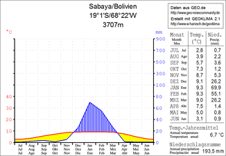
Climate diagram Sabaya |
||
The Río Sabaya is an endorheic river in the South American Andean highlands and flows from Chile to Bolivia .
course
The Río Sabaya has a total length of 125 km. The river rises a few kilometers west of the Chilean border with Bolivia as Río Todos Santos at an altitude of 4252 m and flows for the first ten kilometers through the Región de Tarapacá in northeastern Chile. At ( ⊙ ) at an altitude of 4201 m , the river crosses the border with Bolivia from west to east. The other 115 kilometers the river flows through the western part of the Oruro department , namely the Sabaya Province and the Puerto de Mejillones Province . It bears the name "Todos Santos" for the first 75 kilometers and the name "Río Sabaya" only for the remaining 50 kilometers, before it flows into the Salar de Coipasa salt lake southeast of the village of Sabaya .
climate
The region suffers from great drought for much of the year, the annual precipitation is very low at 200 mm (see climate diagram Sabaya): from April to November the monthly average is less than 5 mm, only in the southern summer months from November to March there is significant precipitation so that the Río Sabaya and its tributaries only carry water periodically. Despite a low annual average temperature of 6 to 7 ° C, there is high solar radiation during the day due to the proximity to the equator; this results in an above-average level of evaporation in the midday hours and the proportion of mineral salts dissolved in the water increases, so that salt crusts and salt pools form along the river.
Web links
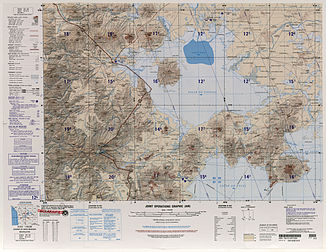
- Map SE 19-15 Salinas de Garci-Mendoza, Bolivia; Chile University of Texas
Individual evidence
- ↑ Detail measurement with the help of Google Earth

