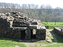
Willowford Roman Bridge
The Willowford Roman Bridge was part of Hadrian's Wall west of the village of Gilsland , Northumberland , England . It is located in the immediate vicinity of the Birdoswald ( Banna ) castle .
From the multi-phase rampart bridge, the remains of the eastern abutment on the banks of the Irthing can still be seen today. Its area is silted up today, as the river bed has shifted further west over time. In the past it was not directly accessible from the fort. Since 1996 it has been accessible via a footbridge that was built by soldiers from the Royal Air Force. An information board on site shows what the eastern abutments of the bridges might have looked like in Roman times. In addition to the remains of the bridge, you can also see a very well-preserved section of ramparts and then visit the Birdoswald castle.
Research history
The excavations in the 20th century uncovered two towers and the foundation walls of the eastern abutment, which represent all construction phases of the bridge. The building history was similar to that of the wall bridge over the North Tyne at Chesters Castle ( Cilurnum ). The foundations of the two bridge piers are now buried under the eastern bank of the river. A total of three construction phases could be verified.
Bridge I.
Bridge I was built entirely in stone from 122–128. The eastern abutment was protected from undercutting in the north and south by quay walls running to the NE and SW. In the east - and probably also in the west - there was a watchtower that secured the entrance to the bridge. It was about as wide as the battlements of Hadrian's Wall (three meters). The bridge stood on three stone arches with triangular breakers on either side. The stone blocks of the masonry were connected to one another by iron brackets. Presumably she fell victim to a flood between 160 and 180. The results of the excavations in the river valley suggest that in Roman times the water was mainly channeled through an artificial canal.
Bridge II
Bridge II was not significantly wider than its predecessor. Two flood channels and a water channel were built under the eastern abutment to prevent it from being undermined during flooding. Perhaps it was used to drive a flour mill. The eastern bridge tower was moved further to the east and enlarged to the south. The masonry of the first tower was partially reused for this purpose. The battlements in front of the tower were also widened somewhat. The two bridge arches in front of it were not rebuilt, but the gap was only made temporarily accessible with an auxiliary construction made of wood. To the north of the wall, a large stone platform was laid out, which was supposed to better support the soft and sandy bank there. Bridge II should have been in function until the early 3rd century.
Bridge III
The bridge III was the first real road bridge, it was built in the course of the expansion of the Wallstrasse in early Severian times. The road ran over a stone-earth ramp onto the bridge, which was now more than twice as wide. For their installation, the tower had to be removed and the abutment widened towards the south. One of the flood channels was blocked. In the course of widening the bridge, the two stone arches were also rebuilt.
literature
- John C. Bruce, Ian A. Richmond: Handbook to the Roman Wall. 12th edition, 1966.
- Shepard Frere: Society for the Promotion of Roman Studies Britannia: a journal of Romano-British and kindred studies. No. 16, 1985 and No. 17, 1986.
- Guy de la Bédoyère : Hadrian's Wall: History and Guide. Tempus, 1998, ISBN 0-7524-1407-0 .
See also
- List of Roman bridges
- Mile fort and watchtowers on Hadrian's Wall
- Newcastle Roman Bridge
- Chesters Roman Bridge
- Stanwix Roman Bridge
Web links
- Images of the remains and reconstruction drawings
- Willowford bridge on English Heritage
- Cilurnum and Wall Bridge on Roman Britain
- Description Fort Birdoswald and rampart bridge with reconstruction drawings
Remarks
- ↑ Bruce / Richmond 1966, pp. 160-162, Frere: 1985 pp. 271 and 1986 pp. 381-382
- ↑ Guy de la Bedoyere 1998, pp. 99-100
- ↑ Guy de la Bedoyere 1998, pp. 99-100
Coordinates: 54 ° 59 ′ 28.7 " N , 2 ° 35 ′ 31.5" W.


