
Cilurnum
| Chesters Castle | |
|---|---|
| Alternative name |
a) Cilurnum , b) Cilurvum , c) Cilurno , d) Celunnum |
| limes | Britain |
| section | Hadrian's Wall |
| Dating (occupancy) |
Hadrianic , 2nd to early 5th centuries AD |
| Type | Alen and cohort fort |
| unit |
a) Legio VI (Bau vexillation ), b) Cohors I Dalmatorum , c) Cohors I Vangionum , d) Ala II Asturum , e) Symmachiarii |
| size | Area: 2.3 hectares |
| Construction | Stone construction |
| State of preservation | square floor plan with rounded corners; large parts of the enclosure, the interior development and the camp bath tw. still several meters high |
| place | Humshaugh |
| Geographical location | 55 ° 1 '33.6 " N , 2 ° 8' 20.4" W |
| Previous | Onnum Fort (east) |
| Subsequently | Brocolitia Fort (west) |

| Aerial view of the fort area |
|---|
| Webaviation |
|
Link to the picture |
| Attempted reconstruction of the fort and the vicus (2nd century), view from the east |
|---|
|
Link to the picture |

Coin portrait of Hadrian

The Building of Hadrian's Wall, by William Bell Scott; John Clayton was portrayed as a Roman centurion (Wallington Hall)
Findings sketch of the fort

Findings plans for the fort gates

Remains of the north gate

Water pipe at the north gate

Ruin of the west gate

Ruin of the east gate

Foundation walls of the north-eastern team barracks

Findings sketch barracks

Remains of the wall of the Principia

Basement room under the flag shrine

Cellar room under the flag shrine (woodcut from the 18th century)
Ruins of the Praetorium

Hypocaust of the Praetorium
Outlet of a sewer in the Praetorium

Gravestone of a Sarmatian cavalryman of the Cohors I Dacorum from Chester (Gosvenor Museum)


.png)


_-_geograph.org.uk_-_1020888.jpg)


.png)

,_Hadrian%27s_Wall_(43845809695).jpg)


Cilurnum was a Roman auxiliary fort in Chesters, north of Hamlet Walwick , a district of the Parish Humshaugh , County Northumbria in north-east England .
It belonged to the chain of fortresses of Hadrian's Wall ( per lineam valli ) consisting of a total of 16 forts and secured its eastern section. The military camp was used for about 300 years, probably from 123 to 400 AD. Its crew was to monitor a bridge over the Tyne and the military road along the wall. It is one of the best preserved forts on Hadrian's Wall. In the provincial Roman archeology , the archaeological site is best known for the bathhouse located outside the camp.
Surname
The place name Cilurnum comes from the Celtic and could mean something like "large basin", presumably a reference to the River Tyne. It is only mentioned in the Notitia Dignitatum . In the cosmography of the geographer of Ravenna , the place was called Celunnum . It is possible that members of the gens Cilurnigorum , a tribe of Asturians who settled near the city of Gigia ( Gijon ), also served in Ala II Asturum .
location
Chesters Castle is the sixth link in the chain of fortresses on Hadrian's Wall ( vallum aelium ). It is located on a bank terrace on the west side of the densely forested North Tyne river valley. Chesters is 20 miles from Newcastle and 27 miles from the east end of the Wall at Wallsend. This is where the highlands begin, the most scenic and topographically varied central part of Hadrian's Wall. In the late 2nd century the region around Cilurnum belonged to the province of Britannia inferior , from the 4th century to the province of Britannia secunda .
Research history
Its location has been known since 1796, as descriptions of the castle ruins from that time have come down to us from travelers. When the ruins of the Roman fort were bulldozed in the early 19th century, Nathaniel Clayton, landlord of Chesters House, retrieved some Roman artifacts that were kept in his collection. The remains of the fort that can still be seen today date largely back to the extensive excavations carried out by John Clayton (1792–1890), who was born and raised in Chesters House, between 1843 and 1890. He was u. A successful lawyer in Newcastle and, as an enthusiastic antiquarian and antique collector, also one of the founders of scientific archeology on Hadrian's Wall. He made a special contribution to the preservation of the Roman monuments in the central part of the wall. This best-preserved section of the wall is still known today as the “Clayton wall”. The Chesters dig was overseen by William Tailford and his son, who dedicated 45 years of their lives to the project. Clayton planned to exhibit the finds in a small museum on site. However, it could only be handed over to its destination five years after his death (1890) by his nephew Nathaniel George Clayton. Much of the fortress and the civil settlement have not been excavated. The finds form the most important and most extensive collection of inscriptions and sculptures on Hadrian's Wall. Nine altars, eleven honorary inscriptions, 13 building inscriptions, five tombstones, ten inscription fragments and a monumental inscription relief were found in and around the fort. John Clayton also bought land around Housesteads Fort, the Mithras Temple of Carrawbourgh , Carvoran and other historic sites to save them from ultimate destruction. In the late 1940s, J. K. St. Joseph took aerial photographs of the area. The southwestern part of the Praetorium was exposed in 1960 by R. P. Harper. Between 1982 and 1991 the excavators of the Royal Commission of Heritage Memorial in England (RCHME) Newcastle concentrated mainly on the investigation and uncovering of the eastern and western abutments of the rampart bridge. In June 1992 a ground radar investigation was carried out inside the fort. A detailed description of the historical sources and a summary of the results of the archaeological investigations were compiled by staff of the English Heritage in 1993.
development
In 122 the Emperor Hadrian ordered a barrier wall to be erected in northern Britain, reinforced by watchtowers and forts, from the Tyne to the Solway Firth , in order to protect the British provinces more effectively from the constant incursions of the Picts from the north. Most of the wall was built by soldiers from the three legions stationed in Britain and seamen from the Classis Britannica .
No forts had been built directly on the original Hadrian's Wall. However, within two years of its completion, the high command made the decision to build 15 additional forts on the wall, which were to be occupied by units of the auxiliary troops. The northern half of the new forts protruded beyond Hadrian's Wall. This was also the case in Chesters. In order to set up the camp at the intended location, the trench on the wall front had to be filled in and a watchtower removed. It is believed that the fortress was built around 123. In addition to Hadrian's Wall, it also secured a bridge over which the wall and the military road over the River Tyne (North Tyne) were led. The remains of its western abutment can still be seen from this bridge.
In its early days, the fort served as a base for a cavalry unit, which from here u. a. raid-like combat missions ( raids ) to the north carried out. Later the riders were temporarily replaced by infantrymen. A consecration altar of the cohors I Dalmatorum found in Chesters in 1978 was dedicated to the cult of the Disciplina , which was particularly promoted by Emperor Hadrian in the army. As with most Roman castles in Northern Britain, the period 180-250 was the heyday of both the fortress and the extensive civilian settlement outside the camp walls. The vast majority of the inscriptions found in Chesters date from this period and relate to building projects, declarations of allegiance to the Emperor, religious ceremonies and the burial of the dead. Around 221, some dilapidated buildings were restored by the Asturian unit , as a building inscription found in the southwest corner of the fort suggests. From the middle to the end of the 3rd century, the Roman Empire saw constant civil wars and invasions by barbarian tribes. In the course of this, the traditional structures of the Roman army also dissolved.
By 300, fewer and fewer inscriptions were being made, making a reconstruction of history or daily life in fourth century Chester very difficult. Materially, the soldiers were much worse off than their predecessors in the middle imperial period. The soldiers' wages were mostly paid in kind, but they are also likely to have received some coins. In the 5th century, Britain slipped more and more out of the control of the Roman central government. According to the Notitia Dignitatum , Chesters was still occupied by the Roman military in the early 5th century. At that time the rest of the cavalry unit was probably only defending an outpost that was largely cut off from the rest of the empire. Archaeological evidence that the fort was occupied by regular troops beyond this period also does not exist. It is therefore uncertain whether the Asturians withdrew around 410 or were simply left to their own devices. No major settlement activity can then be proven in and around the fort. His area was only used for agriculture. Around 675, the Anglo-Saxons demolished the last remains of the rampart bridge in order to obtain building material for a church in nearby Hexham. The south aisle of St. Giles Church in Chollerton is also supported by four Roman columns, which were probably brought here from Cilurnum .
The castle ruins were used as a quarry until the late 18th century. In 1796, Nathaniel Clayton bought all of the land around the fort to build a park there. For this purpose, he had the remains of the wall of the camp covered with earth, creating a flat or gently sloping grassland up to the banks of the Tyne. His son and heir, John, took over the property in 1832. He had the leveling removed to uncover the ruins. In 1954 the fort, the rampart and the bathing building were handed over to the Ministry of Public Works. The successor organization, English Heritage , now looks after the remains and, together with the trustees of the Clayton Collection, also manages the museum.
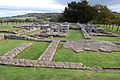
Fort
The NE-oriented fort was very similar to its eastern neighbors and had the rectangular floor plan with rounded corners (playing card shape) typical of mid-imperial fortifications. It measured 122 × 174 meters, covered an area of 2.3 hectares and was built almost entirely of stone. Cilurnum was the third largest fort on Hadrian's Wall. As is usual with the cavalry fort on the Wall, the northern half ( praetentura ) extended beyond Hadrian's Wall. The visible remains of the fort belong to different epochs from its 300-year life. The gates and a large part of the principia date from the reign of Hadrian. Apart from the Housesteads Fort , the remains of the wall are among the most impressive on the wall. Most of the camp's buildings are still buried in the ground. Only a few foundations of the surrounding walls survived the stone robbery - which probably began in Roman times - and the agricultural use of the fort area. The best preserved walls can be seen on the SE corner. You will reach a height of 1.9 meters there.
Enclosure
The 1.5 meter thick walls were reinforced with four corner towers set on the inside and probably eight intermediate towers (two on each side) with a square floor plan. A raised earth ramp served as a battlement. The wall probably reached a height of six meters, towers and gates were probably around nine meters high. In addition, the fort was surrounded by a moat on all four sides. It had four main gates ( portae principales ) and two side gates ( portae quintanae ); The east, west and north gates were north of the wall. This enabled the riders to quickly carry out an outage in the event of an attack. All were each provided with two passages, separated by stone pillars ( spina ) and two square flank towers.
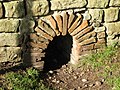
North gate: The water from a spring was collected in a basin in the eastern flank tower of the north gate. It was probably built by the Asturian cavalry unit between 177 and 184 during the tenure of governor Ulpius Marcellus . At a later date, a water pipe covered with stone slabs was laid through the eastern entrance of this gate. The central stop blocks of the gates and the pivot stones can still be seen on the gate thresholds. The western passage was blocked with stone blocks relatively soon after the fort was completed.
West gate: This gate was probably bricked up again shortly after the fort was completed. The passages were probably completely filled with masonry so that a throwing machine ( balista ) could be set up on them. A stone platform was found in the northern flank tower, which probably served as the base for a water tank. One of the water pipes that supplied it with fresh water also reached the fort through an opening in the northwest corner. There was an oven on the north wall of the flank tower. Traces of building structures on the west gate suggest that it was built over in post-Roman times.
East Gate: The gate is one of the best preserved on Hadrian's Wall. The foundation stone of one of its through arches can still be seen at the gate. There is also an iron grommet in a pivot stone, which should prevent wear on the pivot of the gate leaf. Both passages were walled up in Roman times.
South gate: In the gate building there was a diploma from 146, which mentioned the governor Gnaeus Papirius Aelianus Aemilius Tuscillus . An inscription from the Legio VI was built into the inner wall of the eastern flank tower . The road starting from the south gate could be traced for a little more than a kilometer in a south-south-west direction and led to the Stanegate .
Side gates: Of the two side gates, only the eastern example can be seen today. Since the east and west gates were to the north of the wall, most of the road traffic was probably handled through the side gates south of the wall. They also led the via quintana (the southern military road) through the fort.
Interior development
Most of the buildings inside the fort were never excavated. Four building complexes are known and partially visible:
Principia: The warehouse administration building was built according to a standard plan. It essentially consisted of an inner courtyard surrounded by a colonnade and a transverse hall with five adjoining rooms (see Arbeia Castle ). The principia was the seat of administrative officials like the curator Aventinus, who, according to his epitaph , had served in ala II Asturum for 15 years . The courtyard was on three sides with a colonnade ( portico surrounded). This led to the transverse hall ( basilica ), which was oriented from west to east . The latter could be entered through no fewer than five doors from the forecourt and portico. The main entrance in the middle should have been framed by a more elaborately designed portal. Two other entrances were at the western and eastern ends. On the west wall there was a stone platform that served as a platform for speeches by the camp commandant. On the south side of the hall there were four chambers ( officia ) in which the camp administration was housed. The central space between the Officia housed the flag shrine ( sacellum ). In the western side room a staircase led to a cellar in which the troop treasury was housed. When it was discovered in the late 18th century, even the vaulted ceiling was still intact. Subsequently, the remains of the door, which was made of oak, were also found. However, after contact with the air, it disintegrated after a short time. For one of the steps an altar was used, which had been donated by a soldier of the Cohors I Dalmatorum .
Praetorium: To the east of the principia , directly at the east gate, stood the once impressive but now poorly preserved house of the commanding officer of the cavalry unit. The building went through three construction periods, had a hypocaust heater, a heated hall and - later added - a generously equipped bathroom in the east wing. The bath partially overlapped the inner Wallstrasse ( via sagularis ). It is possible that in late antiquity the lower crew could also use the bath. The individual rooms were arranged around an inner courtyard (perystyle house). In late antiquity, a building was added to the flank tower of the east gate north of the Praetorium.
Centuria: Two barracks were partially excavated in the northeastern part of the fort, further barracks are suspected in the southern part of the camp. They are among the best preserved examples in the area of the former Roman Empire. There are two building blocks that were separated by an alley. There was a sewer in the middle. A portico was built in front of the barracks. Its wooden pillars were placed on stone half-columns. The officers ( decuriones ) lived in the somewhat larger head buildings at the eastern end of the barracks. Soldiers and horses were housed in eight chambers / stables ( contubernia / stabuli ), each of which could accommodate about eight soldiers. Ten of them can still be seen today. The stables were right next to the riders' quarters. The horses were in the front and their riders in the rear. This made it possible to saddle up quickly in the event of an alarm. The two barracks blocks offered space for 128 men. This corresponds to the inventory of approx. Four turmae , the smallest tactical unit of a cavalry squadron. The chambers ( papilio ) were probably separated into a sleeping and living area by a wooden wall. The accommodations were remodeled by the Asturians in the later second or early third centuries. The foundation walls that are still visible today date from this time. Due to the ongoing reduction in the number of crews, the accommodations were later reduced in size. To the south of the two barracks there was another barracks for men. Although it was similar to the cavalry barracks, it should have been intended for the infantrymen who briefly occupied the camp.
Horreum: The fort probably had six warehouses, four smaller ones southwest of the Principia and two larger ones (grain stores) at the west gate. A long rectangular building west of the Principia is interpreted as a workshop building ( fabrica ).
Hadrian's Wall
The wall section between Halton Chester and Walwick was almost completely destroyed by stone robbery. When the fort was built in the 2nd century, part of the ramparts and the watchtower 27A were demolished. Its foundations and the associated trench were found on the camp site in 1945. Another 6.7 meter long remnant of the foundation was uncovered north of the bathhouse. Other remains can be seen on the southern flank towers of the east and west gates. The wall (wide version) extended from the Tynebrücke to the southern flank tower of the east or west gate, from where it ran further west. To the west of the fort, the wall can only be seen from 0.4 meter high elevations. According to an inscription (Centurial stone) recovered in 1921, it was built by auxiliary soldiers of the Cohors VIII Sabiniana . The southern moat ( vallum ) can be traced to the west and east of the camp on the basis of 0.3 meter deep depressions. The exact course of the southern vallum around the Chesters camp has not yet been clearly established. Aerial photographs showed that it started near the banks of the Tyne. The course of the military road can still be clearly seen in the section between the North Tyne and the Roman fortress. The route there led from the east gate in the direction of the rampart bridge , the road embankment still reaches a height of 0.8 m in parts there. A curb stone still 1.3 meters high can still be seen there. No remains can be seen to the west of the fort. John Horsley reported in the 18th century that after leaving the west gate, the military road led first to the vallum and then to the north hill.

garrison
During its time of use, the camp was mostly occupied by cavalry units. The tombstone of Marcus Aurelius Victor found in Chesters in the 18th century shows him sitting on a horse with his sword raised. It is only in the middle of the second century that Chesters should not have been occupied by cavalrymen. At that time - between 142 and 160 - the bulk of the border troops were temporarily relocated to the Antonine Wall in Scotland.
The following crew units are known or may have been there for a limited time in Cilurnum :
| Time position | Troop name | description |
|---|---|---|
| 2nd century AD |
Legio sextae Victrix Pia Fidelis (the sixth legion, the victorious, pious and faithful), |
According to an undated inscription, soldiers of this legion probably stayed in the camp between 138 and 161. The legionaries were involved in the construction of the camp under Hadrian. Presumably they also carried out some renovations and structural changes there during the Antonine era. A number of building inscriptions (Centurial Stones) excavated at Cilurnum testify that the soldiers were also used in the construction of Hadrian's Wall in this section. The main camp and headquarters of the Legion was Eburacum (York). |
| 2nd century AD |
Ala Augusta ob virtutem appellata (Augustus' cavalry squadron, the virtuous), |
This cavalry unit of about 500 men of unknown origin may have been stationed in Lancaster in the late 1st century. From 124 to 140 she was in Chesters. Under Antoninus Pius (138) the troops were moved to Carlisle ( Luguvalium ) . |
| 2nd century AD |
Cohors prima Dalmatorum ("the first cohort of the Dalmatians") |
This infantry unit was originally raised in the province of Dalmatia (present-day Bosnia-Herzegovina). It is only mentioned in an undated inscription from Chesters ( Principia ), probably made between 138 and 180. It is possible that she was stationed in Chesters during the Antonine era . While the occupation groups of Hadrian's Wall advanced to Antonine Wall in Scotland, Chesters remained occupied during this time to secure the strategically important rampart bridge. |
| 2nd century AD |
Cohors primae Vangionum Milliaria Equitata (the first cohort of Vangions , partly mounted, 1000 men strong) |
This infantry unit came from the area on the Upper Rhine (area around Worms in Germany). One of their commanders had his daughter buried in Chesters around 160. Other inscriptions mentioning this unit in Chester are not known. It is therefore uncertain whether their soldiers were stationed in the fort for a long time. An inscription on a tombstone in Benwell could mean that unity was split between these two forts. Another of their stationing places on the northern border is the outpost fort of Risingham ( Habitancum ) . |
| 178 to 4th century AD |
Ala secundae Asturum Antoninianae ("the second squadron of Asturians ") |
The unit is also known from an inscription made between 178 and 184. Your soldiers were involved in the completion of the bathhouse and an aqueduct . It was originally set up in the northeast of Spain. The unit remained stationed in the camp even during the Pict campaign of Emperor Septimius Severus and his son Caracalla in the early third century. Under Emperor Elagabal she was given the honorary name "Antoninianae". The downsizing of the barracks suggests that the ala's manpower was reduced significantly in the early third century. In the fourth century the unit was already firmly rooted in the region and recruited its offspring mainly from the sons of the soldiers stationed in the fort and the population of the border areas. After the military reforms of Diocletian and Constantine I , the garrisons on the Wall were part of the limitanei . From the Notitia Dignitatum , list of troops of the Dux Britanniarum , the rank of its commanding officer, a Praefectus , is also passed down for the Cilurno of the 4th century . The name of such a praefectus equitum , Septimius Nilus , is known from an inscription donated in the year 223 from the bathing building. The Asturians were probably stationed in Chesters until the end of Roman rule. Its sister unit, the ala I Asturum , was located in the Condercum (Benwell) fort further east . |
| 3rd to 4th century AD |
Symmachiarii (irregular) |
An inscription of 286 probably refers to allied, irregular fighters who should strengthen the Asturian unit. |
Vicus


.png)


The multi-phase civil settlement belonging to the fort was probably built in the late 2nd century and had its heyday between 180 and 250. The distribution of the buildings probably did not follow a given development plan. The civil settlement has not been extensively investigated archaeologically to this day, but related findings from the other ramparts suggest that it had to be largely abandoned at the end of the third century. Its inhabitants probably withdrew behind the walls of the fort. It is possible that some buildings were still inhabited beyond the 3rd century.
The vicus spread south and southeast of the fortress and along the banks of the Tyne. It covered an area of approximately 15 hectares. An exploratory trench dug by John Clayton, 100 meters south of the fort, is the most noticeable soil feature on the vicus site today. Further buildings are suspected to be southwest of the fort. Its area can only be seen in aerial photographs. In addition to the aerial photographs, further information about the vicus could be obtained through geophysical investigations. In the southeast (settlement core) most of the buildings were oriented from north to south. Further elevations can be seen along the roadside heading northwest to the gardens of Chesters House. The aerial photographs also show the course of wall structures in the extreme southwest, on the property line of Chesters House. The course of two main streets was also observed and traces of other streets are also visible. They divide the vicus into groups of buildings ( insulae ). After the end of the Second World War, J. K. St. Joseph took aerial photographs of the vicus and made the following observations:
“South of the fort near Chesters, the remains of an extensive settlement were visible. The street that starts from the south gate of the fort and turns to the west was connected on the left and right with the side streets of the settlement. These were lined with numerous buildings on both sides, while other buildings were a short distance away. They were mainly long, rectangular structures, as they were familiar to us from the excavations of the civil settlement in Housesteads. Most of them are simple houses, shops or sheds. Here and there more complicated structures appeared, with several rooms and corridors. They were very similar to Roman townhouses in southern Britain. "
The buildings, mostly simply constructed strip houses on stone foundations with wooden and clay walls, were oriented with their narrow side facing the street. The commercial rooms ( tabernae ) were housed in the front part . At the rear there was a small courtyard, workshops or warehouses and the living quarters. Some of the houses surely also had an upper floor that offered additional accommodation or even more storage space. The front sides were usually open, but could be closed with lockable shutters. Other buildings in the vicus probably served as taverns and hostels or the like.
Thermal bath
The multi-phase thermal bath ( balneae ) located outside of the camp was discovered in 1884–1885, 30 meters from the river bank and 70 meters east of the fort. The bath is one of the best preserved Roman structures of its kind in Great Britain. The planing of the site in the 18th century prevented further decay and destruction by stone robbery. Some of the walls have been preserved up to a height of three meters. However, when it was discovered, its true function was not initially recognized. Collingwood Bruce believed the walls were the remains of a fire-destroyed fortification to secure the road from the bridge to the fort. There were two types of Roman bathhouses. One is that of the row type. The rooms were arranged one after the other. You went from the undressing room to the cold bath, then to the warm and hot rooms. In the other construction variant, designed a little more elaborately, the bath cycle took place on a kind of circular path. You first went to the cold bath, then to the warm and hot rooms, but you could also switch between the rooms at will. This can best be seen in the great Imperial Baths in Rome. The Chesters bathroom is a mixture of these two types of buildings. As with all Roman baths that were used over a long period of time, it underwent several structural changes or extensions and repairs. The exact route that the bathers took through the various rooms of the building is therefore still unclear.
building
The NE-oriented bathing building erected in the middle of the 2nd century. Its walls consisted of a quarry stone core bound in mortar, which was faced on both sides with cut stone blocks. The roofing of the bathing building was particularly remarkable. It had been given a standard tile roof. In addition to the high risk of fire, the moist air that constantly pervaded the bathroom also accelerated the rotting process of the wooden roof structure. In Chesters, a vault made of tuff stone ribs, each connected by two layers of brick strips, was therefore drawn in over the cold and warm bath tract. It was supposed to shield the roof structure from the hot, humid air. The brick plate connections between the tuff blocks significantly reduced the weight of the construction. Nevertheless, such a barrel vault still exerted great pressure on the side walls. The location of the bath on a steeply sloping river bank posed an additional problem for its stability. It was solved by adding nine buttresses, which strengthened the west and east walls of the latrine and the hot bath. The lower layers of them are still clearly visible. The wastewater from the latrine was discharged through one of the pillars. In the building itself, the archaeologists found the remains of paved floors, a hypocaust heater and a sewer.
Entrance hall / toilets
The entrance, covered by a narrow porch-like porch, was located in the north, here you entered the slightly lower entrance hall via a staircase. It served as a changing room ( apodyterium ), as a fitness room ( gymnasium ), but was also used for other purposes, e.g. B. body care, social meeting point and for entertainment (e.g. board games) used. Seven arched niches ( cubiles ) are embedded in the west wall, the exact function of which is disputed. It is possible that statuettes were placed in them. However, it is much more likely that the bathers were able to leave their personal belongings there. The remains of a stone bench can still be seen on the north wall. At the door in the east wall you got through a small lobby into the latrine ( latravina ). It was at the lowest point of the bath so that the wastewater from the overflows of the bathing basin could also be used to flush out the faeces. The latrine probably had room for twelve men. A door at the western end of the south wall leads into a narrow chamber ( vestibule ) and a small hallway from which several doors lead to the various heated rooms of the bathhouse. It is possible that this corridor was also used as a massage room ( unguentarium ), where bathers were rubbed with olive oil - the Roman equivalent for soap - before entering the heated sections of the bath.
Cold bath
At the east end of the vestibule was the cold bath ( frigidarium ), equipped with two water basins ( pluteus ) on the north and east walls . The much smaller water basin on the north wall was a later addition. There the dirt could be washed off the body before entering the heated section of the bath. Many bathers sat down in the cold water basin again after the sweat bath to close their pores.
Sweat bath
From the vestibule you got to the sweat bath ( sudatorium / laconicum ) in the west . This room was heated from below by a hypocaust. The hypocaust heating consisted of a series of pillars made of stone pillars on which the floor ( opus signinum ) of the bathroom rests. The hot air circulated in the underfloor chambers and was then diverted outside through hollow tiles in the walls via the roof. The furnace ( praefurnium ) was in the north wall. The heat development in this room must have been so intense that no wood could be used for its structure. The entrance portal also consisted of a massive stone archway. The bathers could only enter it with wooden sandals in order not to scorch the soles of their feet on the floor slabs. There were probably movable wooden benches there that you could sit on. This part of the bathroom appears to be a later addition and was probably not part of the original building.
Warm and hot bath
In the south of the vestibule you got to the hot bath ( caldarium ). A door in the south wall of the cold bath led to the warm bath ( tepidarium ). In the first construction phase, the warm bath could still be entered through the hot bath. This entrance was later walled up. The hot bath had a heatable water basin ( calveus ) that stood in an apsidal extension on the western wall. Warm and hot baths were heated via two furnace openings on the south walls. The bath water was heated in a bronze kettle ( vasa ) immediately above . The hot air was led into the warm rooms through two channels. A second warm and hot bath was located in the south of the cold bath. It was also heated by a hot air duct, which was heated by a furnace in the south wall. It is likely that, together with the cold bath, they formed the core of the original (Hadrianic) bathhouse.
Burial ground
In the 1880s, the skeletons of 33 people, two horses and a dog were found near the bathing building. At the same time, traces of massive masonry were discovered on the riverbank, suggesting that the soldiers and residents of the vicus buried their dead there.
Chesters Museum
The museum was commissioned in 1895 and opened in 1903. The design came from Richard Norman Shaw. The exhibition shows some of the Roman finds from John Clayton's collection. The museum reopened in 2016 after a major renovation. It shows finds from Roman times and tells the story of John Clayton, who owes the preservation of large parts of Hadrian's Wall in the 19th century. His collection now contains around 11,000 objects that Clayton has compiled over time. This also includes phallic fertility symbols that served as lucky charms or to ward off the evil eye. The Romans regularly carved them into military buildings, and Hadrian's Wall has several in the forts at Chesters and Housesteads. With the help of the latest digital technology, the visitor is shown how the life of the Roman soldiers in Cilurnum was .
See also
literature
- John Collingwood-Bruce: Handbook to the Roman Wall. 1863, pp. 109-111 and pp. 117-120.
- John Collingwood-Bruce: Handbook to the Roman Wall. 12th edition, 1966.
- Albert Rivet, Colin Smith: The Place-names of Roman Britain. BT Batsford, London 1979.
- Robin George Collingwood, RP Wright: The Roman Inscriptions of Britain. Vol. 1: Inscriptions on Stone, Oxford 1965.
- Guy de la Bédoyère : Hadrian's Wall: history and guide. Tempus, 1998, ISBN 0-7524-1407-0 .
- Eric Birley: Chester's Roman Fort guidebook. Ministry of Works, 1959.
- RP Harper: Archaeologia Aeliana: or miscellaneous tracts relating to antiquity. No. 39, 1961.
- Paul T. Bidwell, ME Snape: The Roman fort of Chesters and its environs: a survey of the extent and preservation of the archaeological deposits. Museums and Galleries Commission, 1993.
- English Heritage Members 'and Visitors' handbook 2008/2009.
- Peter Salway: The frontier people of Roman Britain. Cambridge classical studies, 1965.
- Nick Hodgson: Hadrian's Wall 1999-2009.
- Nick Hodgson: Chester's Roman Fort . English Heritage, London 2011.
- Nic Fields: Hadrian's Wall AD 122-410. Osprey, Oxford 2003, ISBN 1-84176-430-2 .
- John Kenneth Sinclair St. Joseph: Air Reconnaissance of North Britain. In: The Journal of Roman Studies , 1951.
- RW Davies: The Roman Military Diet. Britannia II, 1971, pp. 122-142.
- Les Turnbull: Hadrian's Wall History Trails Guidebook IV. Newcastle 1974, pp. 3-23.
- EJ Bickerman: Chronology of the Ancient World. Thames & Hudson, London 1980.
- Ronald Embleton, Frank Graham: Hadrian's Wall in the Days of the Romans. Newcastle 1984, pp. 98-113.
- Hadrian's Wall Map and Guide by the Ordnance Survey. Southampton 1989.
- Chris Scarre: Chronicle of the Roman Emperors . Thames & Hudson, London 1995.
- Paul T. Bidwell, Neil Holbrook: Hadrian's Wall Bridges (= English Heritage Archaeological Report. Volume 9). Historic Buildings & Monuments Commission for England, London 1989, ISBN 1-85074-166-2 , pp. 1-47 ( digitized ).
- Margot Klee: Borders of the Empire, Life on the Roman Limes. Konrad Theiss Verlag, Stuttgart 2006, ISBN 3-8062-2015-8 .
Remarks
- RIB = Roman inscriptions in Britain
- ↑ English Heritage Members 'and Visitors' handbook 2008/2009. P. 241
- ↑ A. L. F. Rivet, Colin Smith 1979, pp. 431-433, Guy de la Bedoyere, 1998, p. 57, R & C No. 147, Margot Klee 2006, p. 20.
- ↑ Guy de la Bedoyere, 1997, pp. 58-59.
- ↑ R. P. Harper 1961, pp. 321-326, Eric Birley 1959, Bidwell / Snape 1993, RG Collingwood, RP Wright: addenda and corrigenda by RS O Tomlin, The Roman inscriptions of Britain, 1. Inscriptions on Stone. No. 1448-1496, 1965, pp. 467-480.
- ↑ DISCIPVLINAE IMP HAD AVG ALA AVG OB VIRT APPEL "For the discipline and our emperor Hadrianus Augustus, Augustus' cavalry squadron, the virtuous, [donated this]." RIB 1496a; RIB 1465
- ↑ RIB 1463 , CIL 16, 93
- ↑ RIB 1480 , Nic Fields 2003, p. 25.
- ↑ Guy de la Bédoyère 1998, pp. 57-59
- ↑ Nic Fields 2003, p. 25
- ↑ Guy de la Bedoyere, 1998, p. 59, RIB 1497
- ↑ RIB 1481
- ^ RIB 1471
- ^ Collingwood / Wright, 1965, RIB 1482 .
- ^ ND Occ .: 40, 22, RIB 1467
- ↑ JK St. Joseph 1951, p. 55.
- ↑ Peter Salway 1965, pp. 77–81, Archaeologia Aeliana, No. 5, Series 7, pp. 115–126, Nick Hodgson 2009, pp. 108–110, Nic Fields 2003, p. 25.
- ↑ Guy de la Bedoyere, 1998, pp. 60–61, allocation of functions to the individual rooms according to G. McDonald, 1931.
Web links
- RIB Roman Inscriptions of Britain inscription database
- Hadrian's Wall photo album on Flickr
- Satellite photo of the fort area, location of Roman monuments on Vici.org.
- Chesters Castle on English Heritage
- Description and images on Flickriver
- Description on Historic England
- Chesters Castle on Hist. England / Pastcape (English)
- Description and pictures of the bathing building on Odyssey (English)
- The wall from Arbeia to Maia. Film production with 3D CGI models, images and explanations of the individual Roman castles along Hadrian's Wall, Part V on You Tube.
- Cilurnum on Roman Britain
- Roman artifacts in the Chesters Museum
- John Collingwood Bruce: The Roman Wall: A Description of the Mural Barrier of the North of England. 1867, with numerous pictures of wall remains, altars, inscriptions etc.

Segedunum Castle (Wallsend) | Pons Aelius Castle (Newcastle upon Tyne) | Condercum Castle (Benwell) | Vindobala Castle (Rudchesters) | Onnum Castle (Halton Orchestra) | Cilurnum Castle (Chesters) | Brocolitia Castle (Carrawburgh) | Vercovicium Castle (Housesteads) | Aesica Castle (Great Chesters) | Magnis Castle (Carvoran) | Fort Banna (Birdoswald) | Camboglanna Castle (Castlesteads) | Uxelodunum Castle (Stanwix) | Aballava Castle (Burgh-by-Sands) | Congavata Castle (Drumburgh) | Maia Castle (Bowness-on-Solway)