
Fort Pons Aelius
| Newcastle Castle | |
|---|---|
| Alternative name |
a) Pons Aelius , b) Ponte Aeli |
| limes | Britain |
| section |
a) Hadrian's Wall b) Stanegate ? |
| Dating (occupancy) |
Hadrianic , 2nd to early 5th centuries AD |
| Type |
a) bridgehead fort b) harbor |
| unit |
a) Legio II Augusta (building vexillation ), b) Legio VI Victrix (building crew), c) Legio XX Victrix (building crew), d) Cohors I Ulpia Traiana Cugernorum , e) Cohors I Cornoviorum |
| size | Area: 1 ha |
| Construction | Stone construction |
| State of preservation | Square complex with rounded corners, not visible above ground, as it is now overbuilt by a Norman city castle |
| place | Newcastle upon Tyne |
| Geographical location | 54 ° 34 '57.4 " N , 1 ° 21' 17.3" W |
| Previous | Segedunum Fort (east) |
| Subsequently | Fort Condercum (west) |


.jpg)
_Hadrian%27s_Wall_-_Westgate_Road_-_geograph.org.uk_-_911786.jpg)

Pons Aelius was a Roman bridgehead fort with an attached civil settlement in the urban area of Newcastle upon Tyne ( Metropolitan County ), Tyne and Wear , England .
It was part of the chain of fortresses on Hadrian's Wall ( per lineam valli ), which consisted of 16 forts , secured its eastern section and a bridge over the River Tyne. The camp was used by the Roman military for about 300 years, probably from 122 to 400 AD. Nothing remains of the fort and the bridge today.
Surname
The ancient name of the military site was only handed down in the Notitia dignitatum , a directory of the late Roman administration from the 4th century. It means "Bridge of Aelius" and is derived from the Latin pons (= bridge) and the gentile name Aelii ( nomen gentile ) of the Emperor Hadrian . It was almost certainly used for the fort and the camp village as well. The river was called tinea by the Romans .
location
Pons Aelius was the second link in the fortress chain of Hadrian's Wall ( vallum aelium ). The fort stood west of Segedunum ( Wallsend ) and Arbeia ( South Shields ), north of Concangis (Chester-le-Street), and east of Condercum ( Benwell ) and Coriosopitum ( Corbridge ). It was located on a hill above the north bank of the river, today covered by buildings in the city center, the Norman castle of Newcastle (Castle Keep) and the remains of an Anglo-Saxon church, which is said to have been built in part from stones from the wall. From there one had an excellent view over the river valley of the Tyne. The bridge and the fort stood at the northern end of today's Cade's Road, which in turn lies over a former Roman road. It is believed that it led from Brough-on-Humber, via Eboracum ( York ) to Concangis . There were also a number of small streams (Pandon Burn, Ouse Bourne, Skinner Burn, Lort Burn) that flowed into the Tyne near or directly by the fort. One was passed directly through a culvert under the wall. In the late 2nd century the region belonged to the province of Britannia inferior , from the 4th century to the province of Britannia secunda .
Research history
During the construction of the Swing Bridge in the 1870s, remains of antique wooden beams were recovered from the river, which came from the foundations of the Roman bridge. In 1872 one of their bridge piers was found. Because of the dense overbuilding, the fort could only be examined selectively. To determine its size, Frank G. Simpson carried out an excavation between 1928 and 1929. In the process, parts of the ramparts and wall sections of the commandant's house and hypocaust pillars came to light to the south and west of the residential tower. Subsequently, stones from the fence, roof tiles, broken mortar from the 2nd century and some pieces of leather were recovered during this excavation. The remains of a stone paving date from the 2nd century. From 1960 to 1961, ceramics from the same period were found on the south wall. The clay layer over the cobblestones contained ceramics from the 2nd and 4th centuries. In 1973 an exploration at the Black Gate city gate uncovered a Roman road running from north to south. Possibly it was a section of the rampart road ( via Sagularis ) surrounding the fort. During the excavation in 1978, the individual construction phases of the camp could be determined. In 1994, at the Hilton Hotel in Gateshead , the remains of a Roman settlement and a road were found, possibly the southern approach to the Roman bridge.
Between 1977 and 1992, the archaeologists uncovered over 660 Anglo-Saxon-Christian burials near the railway viaduct and to the west and north of the residential tower. The dead were buried in simple holes, covered with shrouds, in pits lined with wood, in wooden coffins and stone boxes. The graves were partially marked by stones or wooden panels at the head or foot end. Some were covered with decorated flagstones, in one case with a reused Roman milestone. The cemetery was occupied from the 8th to the 10th century.
development
The Stanegate , which marked the northern border until Hadrian's Wall was built, begins east of Coriosopitum / Coria and crosses here with Dere Street, which was the main road to Scotland in antiquity. It is possible that the Stanegate led from Coriosopitum further east to Pons Aelius , but so far no archaeological evidence has been found. In 122 the Emperor Hadrian ordered a barrier wall to be built in northern Britain, reinforced by watchtowers and forts, from the Tyne to the Solway Firth, to protect the British provinces from the constant incursions of the Picts from the north. Most of the wall was built by soldiers from the three legions stationed in Britain and the Classis Britannica .
According to the original plans, the wall in the east should end at Pons Aelius . Between 125 and 127, however, the Roman builders decided to extend the wall a little further to the east in order to be able to better protect the area around the bridge at Pons Aelius and the brigands who settled here . The new wall section extended from Byker, the easternmost borough of Newcastle, to Wallsend . It is believed that the bridgehead fort replaced an older fort at Gateshead, south of the Tyne. During the reign of Septimius Severus (193-211), the old wood-earth camp was removed and a stone fort was built. The archaeologists suspect that market days were also held in the camp between 270 and 360. Around 410 the Roman army withdrew from Hadrian's Wall. After that, Northern Britain suffered more and more from incursions by the Picts and Anglo-Saxons .
What happened in the region around Newcastle after the final collapse of the Roman order, probably around 450, is largely in the dark. The Anglo-Saxon monk and chronicler Beda Venerabilis , who lived in the monastery of St. Paul in Jarrow, mentioned a place called " Ad Murum " (= near the walls) in his writings in the 8th century , which could possibly mean the nearby Newcastle. The Anglo-Saxon name of Newcastle, " Monkchester " (the Anglo-Saxon word " chester " means " fortified place ") has been passed down from the Norman chronicler Symeon . The area of the Roman camp has been used as a cemetery since the 8th century. In 1066 the Norman Duke Wilhelm I passed the bridge on his train to the north. After 1080 the Normans erected a moth over the ruins of the Roman camp , the "New Castle upon Tyne" (= the new castle over the Tyne).
Fort
Above ground nothing can be seen of the fort. Most of its remains are now under the Norman city castle. The positions of the commandant's house ( Praetorium ), the headquarters ( Principia ) and two warehouses ( Horreum ) are known. These were probably type B warehouses - free-standing inside the fort. They are marked by rows of cobblestones in the north and west of the residential tower and at the railway viaduct. The warehouses were in the front part of the fort ( praedentura ), the headquarters and commandant's house in the rear part ( raetendura ). The camp probably had a square floor plan with rounded corners (playing card shape), as was typical of mid-imperial forts. It measured approx. 100 × 100 meters and covered an area of 1.1 hectares. This made it - next to Drumburgh - one of the two smallest ramparts. A total of four construction phases could be identified. There are also indications of a period of time when the fort was clearly neglected or abandoned. The fence consisted of a stone wall, on its back an earth wall had probably been piled up, which also supported it and served as a battlement. The fort may also have four access gates. To the south of the fort, at the Praetorium, traces of a V-shaped weir ditch ( fossa ) were found. Part of the trench could also be seen west of the camp, at the Clavering House.
- Phase I: The early wood and earth fort was destroyed by fire and replaced by a stone building at the end of the 2nd century. There were two 6.52-meter-wide warehouses in the fort; the western one was provided with three long partition walls. The side walls of the buildings were reinforced with pilasters . It had been laid out over the older wood and earth wall. The ceramic from the building was dated to the 2nd or early 3rd century. To the north of the warehouse there was an ash pit, a stone-lined gutter, and a slightly raised area, perhaps an open courtyard. At the east end a street passed the building. The staff quarters with a cellar were built in the late 2nd or early 3rd century. In the staff building there was an inscription for the Empress Julia Domna .
- Phase II: An east-west road was laid out along the south wall. The commandant's house was renovated and provided with hypocaust heating .
- Phase III: In the second half of the 3rd century the fort was temporarily abandoned.
- Phase IV: In the 4th century the fort was occupied again. The western Horreum and the buildings at the northern end of the main camp street ( via Praetoria ) were demolished. A canal to a cistern was dug across the ruins of the eastern Horreum. At the upper end of the east-west street was a structure of unknown function made of solid stone blocks.
Hadrian's Wall
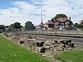
The exact course of Hadrian's Wall near the Roman fortress has not yet been determined. It is therefore not known whether the fort wall - as with the fort in Wallsend - was connected to the wall. It could be that it passed Pons Aelius a little further north (south of today's St. Nicolas Church). Westgate Road largely marks the course of the wall between Benwell and Newcastle city center. The road covers the northern moat of Hadrian's Wall. The line of the wall along Westgate Road continues to a traffic island where it continues under the statue of George Stephenson, then across Neville Street (in front of the train station) to the Mining Institute building. There is also a plaque with information about the wall. In 1826 a building inscription was found in the foundations of the Low Gosforth House in Newcastle, which came from the wall 4 miles away. She names a 7th cohort who was probably responsible for the construction of the wall section in this region. Traces of the southern trench ( vallum ) have been observed at Arthur Hill, west of the city center.
garrison
Little is known about the occupation troops of the fort. Two altars for Neptune and Oceanus , donated by soldiers of the Legio VI Victrix , were found in 1875 and 1903 near the fort and the ancient bridge in the Tyne. An inscription from the period between 155 and 159 discovered in 1903 in the north channel of the Swing Bridge names all three legions stationed in Britain. The legionaries were mainly used in the construction of the ramparts and bridges. In the 2nd century two auxiliary troop units ( auxilia ) were probably stationed there as a crew. Judging from the size of the fort, however, they could only have had a crew of approximately 250 men. To the south of Hanover Square in Newcastle an inscription of the Cohors I Thracum was found . But it is unlikely that she was stationed in the fort for a long time. She probably had her quarters in a camp on the south bank of the Tyne, later she was moved to Fort Birdoswald ( Banna ).
The following auxiliary units are known or may have been crewed for Pons Aelius for a limited time:
| Time position | Troop name | description |
|---|---|---|
| 2nd century AD |
a) Legio secundae Augusta ("the second legion of Augustus "), |
Vexillations of these three British legions were probably stationed here temporarily for construction work. According to the inscription on the Neptune Altar, they were under the command of the governor Gnaeus Iulius Verus , who fought insurgents in northern Britain around 158. |
| 2nd century AD | Cohors I Ulpia Traiana Cugernorum civium Romanorum ("the Cugern cohort of Ulpius Traianus , Roman citizens") | A cohort of auxiliary troops that had been set up in Lower Germany under Emperor Trajan. The unit donated an honorary inscription to the Empress Julia Domna . It has been detectable in Britain since 103 and could originally have been between 480 and 500 men strong ( quingenary ). It is believed to have existed for almost four centuries. It is unclear whether they also had cavalrymen in their ranks. |
| 4th century AD | Cohors primae Cornoviorum ("the first cohort of the Cornovians ") | The Cornovians are unique among indigenous units in that, unlike the rest of the British cohorts, they were stationed in their homeland. The Cornovian (or Kornen) people settled in what is now the counties of Cheshire and Shropshire , north-west England. Their metropolis was Viroconium Cornoviorum (Wroxeter), near Shrewsbury . It is the only known British unit posted to Hadrian's Wall. It probably stood on the wall until the Romans withdrew or the provincial army was dissolved in the 5th century. From the Notitia Dignitatum , troop list of the Dux Britanniarum , the rank of its commanding officer, a tribunus , is known for the Ponte Aeli of the 4th century . |
Aelian Bridge
The bridge was the only one outside of Rome to be named after an emperor, which underlines its special importance for road traffic on Hadrian's Wall. The most important task of the fort crew was therefore also to secure the river crossing or the bridgehead. It is estimated to be 225 meters long and around five meters wide. The deck and main girder were probably made of wood, only the ten pillars and the two abutments were probably made entirely of stone. The pillar that was found in 1872 was 4.8 meters wide and six meters long. Its foundation consisted of a caisson made of closely set iron-studded oak posts. The interior was filled with rubble. The pillar had breakwaters on both sides. Two altars donated by soldiers of the Legio VI Victrix to Neptune and Oceanus allow the conclusion that the bridge was built by this legion. It was probably built before the fort (122) and was in use until 1248. That year their superstructure was destroyed by fire. The Roman road led from the bridge, south or south-east, roughly along today's West Street to the fort. It is very likely that the bridge, built in the late 12th century, was built on top of Roman foundations. In place of this bridge, which partially collapsed due to flooding in 1771, there is now the Swing Bridge, built in the late 19th century.

Vicus
Despite the important river crossing, the civil settlement was of little economic importance compared to other Roman settlements in the north. The larger settlements or cities were on Dere Street , which led from Eboracum to the tribal areas north of the wall. Even the nearby Coriosopitum supply base was much larger and more populous. The population of Pons Aelius - including the castle garrison - should never have exceeded 2000 inhabitants. Traces of the camp village were observed - west of the fort - in the area around today's Hanover Square. A recently discovered inscription tells of the restoration of a bathhouse that apparently stood outside the fort ( extra muros ).
Inscriptions
The discovery of some Roman altars and dedicatory inscriptions (an altar for Silvanus and an unlabeled copy, both of which were walled into the foundations of the White Friar's Tower in Newcastle, which was demolished in 1843) suggest that there is also a divine shrine , temple or one in the vicinity of the fort Kind of Holy District located. Two altars discovered in Newcastle were dedicated to the supreme imperial god Iupiter. There are also two inscriptions of the mother goddesses , one on a relief depicting three seated female figures and another on a damaged altar stone. The name of the deity was no longer legible on another fragment of the altar that was recovered there.
The altars for Neptune and Oceanus were perhaps in a sanctuary right next to the bridge or on both sides on the central pillar of the bridge. At the point where Neptune, symbolizing the River Tyne, met the waves of the Oceanus. On the front of the Neptune altar are two symbols of the god, a dolphin with a trident. The altar of Oceanus is decorated with a ship anchor. The two altars were in remarkably good condition when they were discovered in the river bed. Some scholars believe it may have been intentionally thrown off the bridge as part of the dedication ritual.
See also
- Mile fort and watchtowers on Hadrian's Wall
- List of Roman bridges
- Willowford Roman Bridge
- Chesters Roman Bridge
- Stanwix Roman Bridge
literature
- John Collingwood-Bruce: Handbook to the Roman Wall. 12th edition, 1966.
- Graham Webster: The Cornovii. London 1991 ISBN 0-86299-877-8 .
- Barbara Harbottle: The Castle of Newcastle upon Tyne. Society of Antiquaries of Newcastle upon Tyne. Newcastle upon Tyne, 1977. ISBN 978-0-901082-65-7 . P. 1.
- Eilert Ekwall: The Concise Oxford Dictionary of English Place-names. Clarendon Press. 4th edition, Oxford 1936–1980.
- ALF Rivet, Colin Smith: The Place-names of Roman Britain. Batsford Ltd., London 1979-1982.
- AD Mills: Oxford Dictionary of British Place Names. Oxford University Press, 1991-2003.
- MJT Lewis: Temples in Roman Britain, Cambridge classical studies. University Press, Cambridge 1966
- David J. Breeze, Brian Dobson: Hadrian's Wall. 1976.
- Frank Gerald Simpson, GRB Spain: The Roman Wall. Northumberland County History. XIII, 1930.
- Frank Gerald Simpson; published d. Grace Simpson: Watermills and military works on Hadrian's Wall: excavations in Northumberland, 1907-1913, 1976.
- Anthony R. Birley: The people of Roman Britain. University of California Press, 1980, ISBN 978-0-520-04119-6 .
- Nick Hodgson, Hadrian's Wall 1999-2009, pp. 83-85.
- Guy de la Bédoyère : Hadrian's Wall: history and guide. Tempus, 1998, ISBN 0-7524-1407-0 .
- Sydney Middlebrook: Newcastle upon Tyne, Its Growth and Achievement. SR Publishers Ltd., 1950, ISBN 0-85409-523-3 .
- Archaeologia Aeliana - Fifth Series, Volume XXXI - The Roman Fort at Newcastle Upon Tyne published by The Society of Antiquaries of Newcastle upon Tyne, 2002.
- Colin O'Connor: Roman Bridges. Cambridge University Press, 1993, ISBN 0-521-39326-4 .
- Hadrian's Wall Map and Guide by the Ordnance Survey, Southampton, 1989.
- Ronald Embleton, Frank Graham: Hadrian's Wall in the Days of the Romans. Newcastle 1984, pp. 47-51.
- RG Collingwood, RP Wright: The Roman Inscriptions of Britain. Oxford 1965.

Remnants of Hadrian's Wall at the West and Denton Road roundabout

Remnants of the wall on Denton Road
Hadrian's Wall remains on the A69 / The Rampart
Remains of the wall on the A69 / The Rampart, near the intersection with the A1 (with a display)

Wall remains on the A69 / The Rampart, near the intersection with the A1
_Hadrian%27s_Wall_-_geograph.org.uk_-_837908.jpg)
_Hadrian%27s_Wall_(2)_-_geograph.org.uk_-_837930.jpg)
_Hadrian%27s_Wall_(2)_-_geograph.org.uk_-_837968.jpg)
_Hadrian%27s_Wall_-_geograph.org.uk_-_837970.jpg)
_Hadrian%27s_Wall_-_geograph.org.uk_-_837959.jpg)
Remarks
- RIB = Roman inscriptions in Britain
- ↑ ALF Rivet, Colin Smith 1979, p. 441.
- ↑ David J. Breeze, Brian Dobson 1976, p. 272, Frank Gerald Simpson 1976. pp. 170, 175, 188-192.
- ↑ Barbara Harbottle 1977, p. 1.
- ↑ Guy de la Bedoyere 1998, p. 41
- ^ RIB 1324
- ↑ RIB 1319 , 1320 , RIB 1322 , Anthony R. Birley 1980, p. 82. Notitia Dignitatum Occ: XL XIX, Simpson / Spain 1930, pp. 484-564, RIB 1323 .
- ↑ IVLIAE AVG NO ... MATRI M AVRELI ANTONINI AC CASTR AC SENATE AC PATRIAE PRO PIETATE AC DEVOTIONE CVRANTE G IVL MARCO LEG AVG PR PR COH VLPIA TRAIANA CVGERNORVM CR POSVIT "For the noble Julia Augusta, mother of Marcus Aurelius Antoninus, the camp , the Senate and the Fatherland. Out of loyalty and devotion, under the command of Gaius Julius Marcus, pro-Praetorian legate of the emperor, the first Cugern cohort of Ulpius Traianus, Roman citizens, put this inscription. " (RIB 1322c; originated around 213; from Britannia XI, 1980, p. 405, no.6.)
- ↑ Graham Webster 1991, ND Occ. XL 18.
- ^ John Collingwood-Bruce: 1966, p. 46, RIB 1319 , Colin O'Connor 1993, p. 147.
- ↑ C ... AV ... BALINEVM ... A SOLO ... "For C [aesar ...] Au [gustus ...] the bathhouse [...] from scratch [...]" , RIB 1322d, Britannia XXX, 1999, p. 380, No. 5.
- ↑ RIB 1321 and RIB 1322b .
- ^ MJT Lewis 1966, pp. 2-3, Madeleine Hope Dodds: A history of Northumberland, Vol. 13, 1930, the parishes of Heddon-on-the-Wall, Newburn, Long Benton and Wallsend […] the townships of Benwell , Elswick, Heaton, Byker, Fenham and Jesmond, A history of Northumberland, Vol. 15 (1893-1940), Vol. 13, pp. 506, 545-546, RIB 1321 , RIB 1316 , RIB 1317 , RIB 1318 .
Web links
- RIB Roman Inscriptions of Britain inscription database
- Hadrian's Wall photo album on Flickr
- Satellite photo of the fort area, location of Roman monuments on Vici.org.
- Reconstruction of the bridge and the fort
- Video reconstruction of Hadrian's Wall (You Tube)
- The wall from Arbeia to Maia. Film production with 3D-CGI models, images and explanation of the individual Roman castles along Hadrian's Wall, Part III on You Tube.
- Pons Aelius on Roman Britain
- John Collingwood Bruce: The Roman Wall: A Description of the Mural Barrier of the North of England, 1867, with numerous pictures of wall remains, altars, inscriptions etc.

Segedunum Castle (Wallsend) | Pons Aelius Castle (Newcastle upon Tyne) | Condercum Castle (Benwell) | Vindobala Castle (Rudchesters) | Onnum Castle (Halton Orchestra) | Cilurnum Castle (Chesters) | Brocolitia Castle (Carrawburgh) | Vercovicium Castle (Housesteads) | Aesica Castle (Great Chesters) | Magnis Castle (Carvoran) | Fort Banna (Birdoswald) | Camboglanna Castle (Castlesteads) | Uxelodunum Castle (Stanwix) | Aballava Castle (Burgh-by-Sands) | Congavata Castle (Drumburgh) | Maia Castle (Bowness-on-Solway)

Pons Aelius Castle (Newcastle upon Tyne) | Coriosopitum (Corbridge) | Newbrough forts | Vindolanda (Bardon Mill) | Haltwhistle Burn (Haltwhistle) | Magnis Castle (Carvoran) | Small fort Throp | Nether Denton Fort (Nether Denton) | Castle Hill (Boothby) | Old Church Castle (Brampton) | Luguvalium Castle (Carlisle) | Fort Portus Trucculensis (Kirkbride)