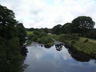
River Irthing
| River Irthing | ||
|
Course of the Irthing River |
||
| Data | ||
| location | Northumberland , Cumbria , England | |
| River system | Eden | |
| Drain over | Eden → Solway Firth | |
| origin | Confluence of the Tarn Beck and Gair Burn at Irthing Head in the Cheviot Hills 55 ° 5 ′ 57 ″ N , 2 ° 35 ′ 0 ″ W |
|
| muzzle | east of Carlisle in the Eden Coordinates: 54 ° 54 ′ 49 " N , 2 ° 49 ′ 45" W 54 ° 54 ′ 49 " N , 2 ° 49 ′ 45" W
|
|
| length | 55 km | |
| Left tributaries | River Gelt | |
| Right tributaries | King Water , Cam Beck | |
|
The Irthing at Lanercost |
||
The River Irthing is a river in northern England . It arises from the confluence of the Tarn Beck and Gair Burn on the western edge of the Cheviot Hills (approx. 490 m ASL ) on the border of Northumberland and Cumbria . It begins its course in an easterly direction up to Whitehill on the south side of which it takes a southerly direction. It initially flows on the east side of Gavelock Hill, but turns on its south side in an initially generally south-westerly direction and later in a direct southerly direction. It approaches Gilsland from the north, where it changes its direction to the west. It flows into the River Eden near the city of Carlisle . Its length is 55 km. After about 1/3 of its length it crosses the Roman Hadrian's Wall near Gilsland .
The Irthing is a shallow river that easily overflows its banks after rainfall. The first stretch of the river forms part of the border of Northumberland National Park as well as the border of Northumberland and Cumbria. On reaching Gilsland, it flows from Northumberland to Cumbria. In the Irthing you can find salmon and trout . The place Irthington was named after the river.
swell
- Haltwhistle and Brampton, Bewcastle and Alston (= Landranger Map . Band 86 ). Ordnance Survey , Southampton 2009, ISBN 978-0-319-23166-1 .

