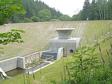
Retention basin Glashütte
| Retention basin Glashütte | |||||||||||
|---|---|---|---|---|---|---|---|---|---|---|---|
| Construction site as of September 2011 | |||||||||||
|
|||||||||||
|
|
|||||||||||
| Coordinates | 50 ° 50 ′ 41 ″ N , 13 ° 45 ′ 14 ″ E | ||||||||||
| Data on the structure | |||||||||||
| Lock type: | Rock embankment dam with mineral and geotextile inner seal | ||||||||||
| Construction time: | 1951–1953 2009–2013 |
||||||||||
| Height above valley floor: | 28 m | ||||||||||
| Height above foundation level : | approx. 30 m | ||||||||||
| Height above the river bed : | 28.28 m | ||||||||||
| Height of the structure crown: | 408.2 m | ||||||||||
| Building volume: | 0.225 million m³ | ||||||||||
| Crown length: | 184 m | ||||||||||
| Crown width: | 5 m | ||||||||||
| Slope slope on the air side : | 1: 2.5 | ||||||||||
| Slope slope on the water side : | 1: 2.5 | ||||||||||
| Data on the reservoir | |||||||||||
| Altitude (at congestion destination ) | 387.9 m | ||||||||||
| Water surface | 11.1 ha | ||||||||||
| Storage space | 1.05 million m³ | ||||||||||
| Total storage space : | 1.20 million m³ | ||||||||||
| Catchment area | 11.6 km² | ||||||||||
| Design flood : | 54 m³ / s | ||||||||||
The Glashütte flood retention basin is a retention basin in the Free State of Saxony . It is used for flood protection in the Müglitztal (Eastern Ore Mountains).
Barrier structure
The original barrier structure was a homogeneous earth dam . The structure was built between 1951 and 1953 above Glashütte . The dammed body of water is the Brießnitzbach (also called Prießnitz), a tributary of the Müglitz . The basin is normally empty, ie a "green basin", and is only dammed during flooding.
Destruction of the dam
The dam was destroyed in the flood in August 2002 . It broke at around 4:30 p.m. on August 12, 2002. The tidal wave did not cause any fatalities, but caused considerable damage and destruction in the city center of Glashütte, which was not previously affected by the flood of the Müglitz. In the Müglitztal, due to the generally severe flood situation, there was hardly any significant increase in damage caused by the dam breach. The dam was rebuilt to its original height in 2006. The reconstruction costs amounted to approx. 2.5 million euros.
expansion
The state dam administration of Saxony expanded the retention basin as part of the implementation of expanded flood protection concepts that were developed after the flood in 2002. The new Prießnitz dam has the following data:
- Dam height: 28.28 m above the river bed
- Crown length: 184 m
- Crown width: 5 m
- Storage space : 1.05 million m³
The expansion made it necessary to re-route the road to Johnsbach in sections as well as the access to the Stadtbad. The renovation began in February 2009 with initially estimated costs of around 12 million euros. After more than three years of construction, the flood retention basin in Glashütte was inaugurated on November 11, 2013. The construction costs came to around 26 million euros.
See also
literature
- Christian Striefler: The flood - a look back ahead . Ed .: Saxon State Chancellery, Public Relations Department. Free State of Saxony, Central Brochure Dispatch of the Saxon State Government, Dresden 2003 (contains information on the dam breach; free of charge).
Web links
- The rupture of the Glashütt e flood retention basin (PDF, 128 kB) TU Dresden
- Floods in August 2002 . ( Memento from July 31, 2007 in the Internet Archive ) (PDF; 3.94 MB) LFUG Saxony, July 2004; with description and photos of the dam breach (from p. 93)
- Report of the Independent Commission of the Saxon State Government Flood disaster 2002 (PDF; 1 MB) - Kirchbach report , contains information on the dam breach
- Dams directory 2002: Dams, water reservoirs and flood retention basins in the Free State of Saxony (contains structural data)
- Information on the current construction, before / after simulation of the construction project
Individual evidence
- ↑ a b c d e f g h i j Glashütte flood retention basin at the state dam administration
- ↑ Antje Bornschein: Hazard maps - an instrument for risk assessment as a result of a hypothetical dam breach, Scientific Journal of the Technical University of Dresden • 55 (2006) Issue 3–4. This publication shows the flow peaks in the Prießnitz and Müglitz as a result of the dam breach.
- ↑ Maik Brückner: The dam is three times as high. Sächsische Zeitung (Pirna edition) of June 13, 2008, p. 20
- ↑ Maik Brückner: water stop on Prießnitzdamm. In: Saxon newspaper. November 12, 2013, accessed September 29, 2014 .


