Rüdersdorf (Kraftsdorf)
|
Rudersdorf
Community Kraftsdorf
Coordinates: 50 ° 53 ′ 57 ″ N , 11 ° 57 ′ 35 ″ E
|
|
|---|---|
| Height : | 287 m |
| Area : | 10.2 km² |
| Incorporation : | January 1, 1997 |
| Postal code : | 07586 |
| Area code : | 036606 |
|
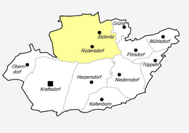
Location of Rüdersdorf in Kraftsdorf
|
|
|
Street in Rudersdorf
|
|
Rüdersdorf is a part of the municipality of Kraftsdorf in the district of Greiz in Thuringia .
geography
Rüdersdorf is located in a hollow on a higher level north of the federal highway 4 and also away from Kraftsdorf. The district is connected to the Erlbach valley via district roads and to the surrounding area via state road 1070. The agricultural town has 1020 hectares of municipal area.
history
The village was first mentioned in a document on February 19, 1160.
Until the state of Thuringia was founded in 1920, the community consisted of two parts, one of which belonged to the Principality of Reuss younger line , rule Gera (1919 with 450 inhabitants) and one to the Principality of Saxony-Altenburg , Eisenberg district office (266 inhabitants). On July 1, 1950, the community Grüna (1939: 105 Ew.) Was incorporated into Rüdersdorf. Rüdersdorf himself came to Kraftsdorf in 1997 . Rüdersdorf belonged to the Gera-Land district until the end of June 1994 and has belonged to the Greiz district since the district reform in Thuringia in 1994 .
Attractions
The village church is visible from afar. Rüdersdorf is also known for its Schalmeienkapelle.
Population development
| year | Residents | year | Residents |
| 1910 | 786 | 1919 | 716 |
| 1925 | 903 | 1933 | 925 |
| 1939 | 908 | 1945 | 1358 |
Web links
Individual evidence
- ^ Wolfgang Kahl : First mention of Thuringian towns and villages. A manual. Verlag Rockstuhl, Bad Langensalza, 2010, ISBN 978-3-86777-202-0 , p. 241


