
Pool
| Reef ponds | ||
|---|---|---|

|
||
| Middle Raffteich with island, looking west, 2013 | ||
| Geographical location | Braunschweig , Lower Saxony | |
| Drain | New ditch (Schölke) | |
| Data | ||
| Coordinates | 52 ° 15 '36 " N , 10 ° 27' 24" E | |
|
||
| Altitude above sea level | 84 m above sea level NN | |

|
||
| Map of the reef ponds in Westpark | ||

Historical ponds in the western urban area of Braunschweig are referred to as reef ponds , with reef ponds generally referring to the uppermost, western source pond. This was used as a bathing lake for several decades. On the site of the source pond, which is also used for open-air events, there is a 50-meter sports swimming pool, the Raffteichbad . The reef ponds are part of the West Park .
location
The ponds are located in the Feldmark of Lehndorf south of Bundesstraße 1 at the Raffurm . In old maps, the three ponds are listed as Upper , Middle and Lower Raffteich or also Hinterster , Middle and Large Raffteich . Since the 1960s there have been four bodies of water called fish ponds at the location of the two lower ponds. When the Westpark was laid out in 1980, another pond was created south of the Mittlerer Raffteich in the Wilder Boden corridor , which has no name on the official maps.
| Surname | surface |
| Upper pool | 15.2 hectares |
| Middle reef pond (also called spring pond) | 26.4 hectares |
| Lower Raffteich, western part (fish pond) | 25.5 hectares |
| Fish pond (northern pond) | 6.4 hectares |
| Fish pond (southern pond) | 4.8 hectares |
| (nameless) | 7.6 hectares |
The upper pond, which is uniformly referred to as the Raffteich on all maps, is about 84 m above sea level. NHN and is a natural spring pond whose water is drained into the ponds below. The middle pond, like those below, is leased to a fishing club, which calls it the spring pond . The last two ponds are closed by an approximately three meter high dam. Via a drainage structure in the northern small pond, the water flows through the dam into the Neue Graben . This is at a level of about 79 m above sea level. NHN .
The lower ponds are integrated into the access routes of the Westpark, while the upper pond is located on the fenced off area of the Raffteichbads.
It has been classified as a natural monument (ND-BS 14) since 1959 , but was allowed to be used for swimming purposes to a limited extent.
history
The ponds were probably created as fish ponds in the 13th century. Like the Lehndorfer Feldmark, they belonged to the Braunschweig Kreuzkloster . After 1835, only one pond is marked as a body of water on the historical map sheets, while the names of the other ponds are still recorded on some maps. From 1899 the lower ponds are no longer mapped, instead the contour lines of the terrain through which the Neue Graben runs are drawn.
From 1960 the existing fish ponds were re-established, which are maintained as leased waters by a fishing club. The ponds are stocked with white fish, perch, eel, carp, tench, pike and pikeperch. In 2009 the club tried to clear the heavily silted middle pond, but it was only partially successful.
Bathing establishment
The upper pond has been used as a bathing pond since the beginning of the 20th century. In 1977 an outdoor pool with a length of 50 meters was inaugurated on the meadow area, which can also be used for swimming competitions. The bath is operated by Stadtbad Braunschweig GmbH. In order to enable swimming in heated water in winter too, the pool was spanned with an air dome. This construction was far more cost-effective than building a hall, but only existed until 1988. It was not renewed, instead the construction of the sports swimming pool in Heidbergbad, which opened in 1993, was planned.
Others
The Raffteich area is a regular venue for concerts.
Picture gallery

Lower Raffteich, the southern section, from the Mitteldamm towards the south, May 2013

Runoff from the northern fish pond into the Neue Graben, 2013
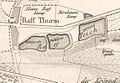
Map of the reef ponds around 1835


literature
- Luitgard Camerer , Manfred Garzmann , Wolf-Dieter Schuegraf (eds.): Braunschweiger Stadtlexikon . Joh. Heinr. Meyer Verlag, Braunschweig 1992, ISBN 3-926701-14-5 .
- Margot Ruhlender, publisher Wolf-Dieter Schuegraf on behalf of the city of Braunschweig: Büketubben: History of bathing culture in Braunschweig from 1671–1993. Joh. Heinr. Meyer, Braunschweig 1994, ISBN 3-926701-23-4 , pp. 142-152.
See also
Web links
Individual evidence
- ↑ Land surveying and geographic base information Lower Saxony: AK 5 , LGLN online map ( Memento of the original from March 19, 2015 in the Internet Archive ) Info: The archive link was inserted automatically and has not yet been checked. Please check the original and archive link according to the instructions and then remove this notice. (February 4, 2014).
- ↑ a b Klub Braunschweiger Fischer, H. Jäger: Der Quellenteich , Internet presence Klub Braunschweiger Fischer (February 27, 2014) ( Memento of the original from March 3, 2014 in the Internet Archive ) Info: The archive link was inserted automatically and has not yet been checked. Please check the original and archive link according to the instructions and then remove this notice.
- ^ City of Braunschweig: Ordinance on the safeguarding of natural monuments in the city of Braunschweig of March 31, 1959 , Braunschweig, June 1959
- ^ Luitgard Camerer , Manfred Garzmann , Wolf-Dieter Schuegraf (eds.): Braunschweiger Stadtlexikon . Joh. Heinr. Meyer Verlag, Braunschweig 1992, ISBN 3-926701-14-5 .